

 English
  Français
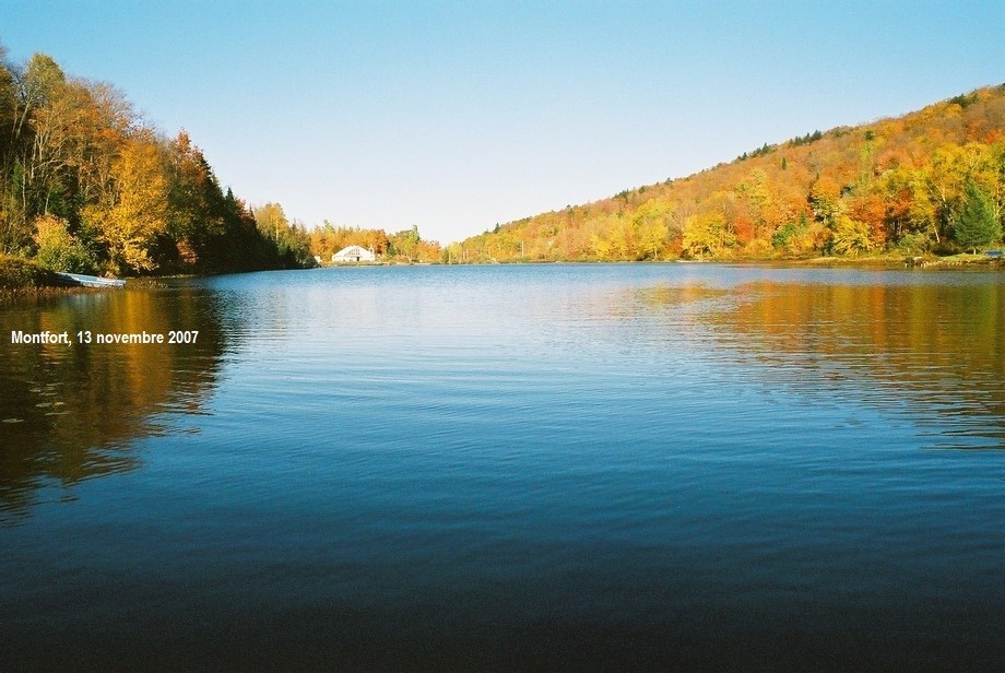
Montfort
- The cart before the horse (Phase 2 of the Domaine du Mont project)
- Consultation of May 1, 2024, 6:30 p.m.
- “More problems with the Montfort Pavilion”
- Montfort pavilion at the PTI
- Newaygo Bridge For Cyclists!
- Semi-buried bin emptying
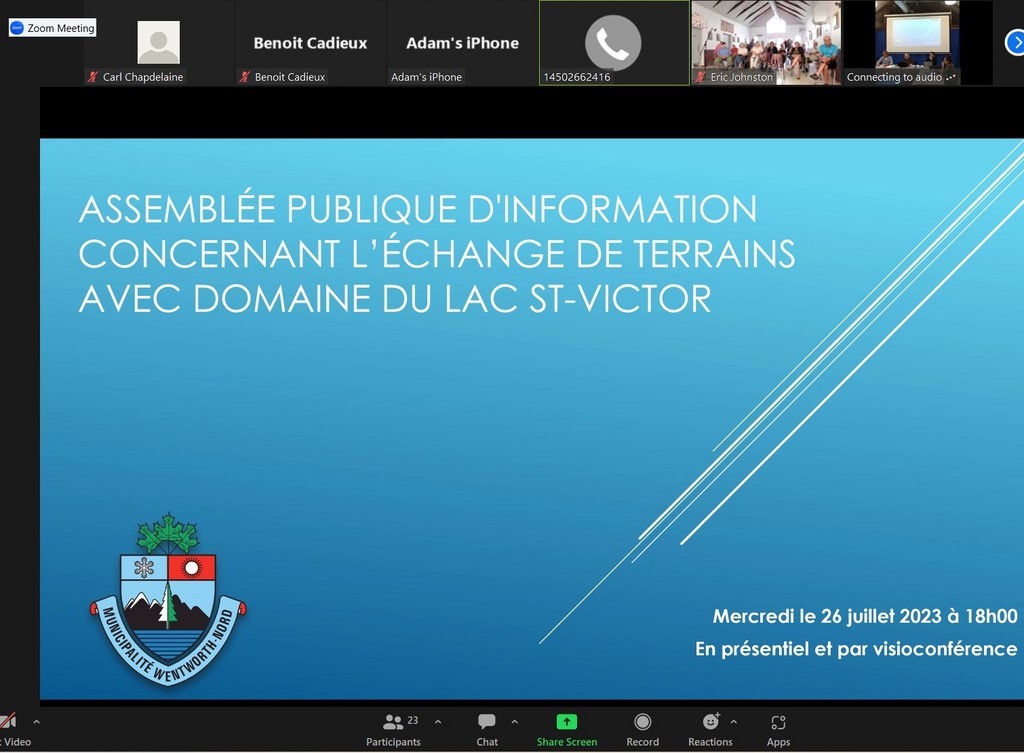
- Consultation of July 26, 2023 : 1. Land swap with Lac St.Victor E. 2 . Pavilion
- The Pavillon, a regional socio-cultural and recreational center
- Public consultation on the purchase of the Montfort Pavilion
- A revamped Pavilion?
- Du Mont project, phase 2
- Is The future of the Montfort Pavilion sealed? (Opinion)
- Church pews for sale
- Real estate: petition vs. moratorium
- François Froidevaux and the Montfort Colonization Railway
- Meeting with the mayor Saturday, oct 22
- Blind property taxes
- information meeting on Chemin de Fer’s maintenance
- Wentworth-Nord Wants to repurchase Montfort Pavilion
- Safety and transparency please!
- Petition and moratorium on real estate development in Wentworth-Nord
- Petition for Moratorium on Development in Montfort sector
- Presentation of Domaine du Lac Pelletier project
- Montfort Railway CN Stations from St-Eustache to Huberdeau
- Two projects for Lake Saint-François-Xavier (Report)
- The Montfort/Newaygo Regatta
- MRC Council meeting of July 12, 2022 (report)
- Entente MRC-Wentworth-Nord sur le pavillon Montfort
- Welcome at the Montfort Pavilion
- The future of the Montfort Pavilion (question for the mayors' council)
- Montfort consultations, summary
- 1st Consultation Session on Monfort: Aerobic Corridor, lake SFX (Report)
- 2nd Montfort Consultation Session, Pavilion, parking (report)
- 3rd consultation session on Monfort: right to occupy, to circulate (report)
- 3 consultations (ZOOM) in Montfort
- Montfort Consultation, Topic 3: MTQ and Right to Occupy
- Monfort Consultations, Topic 2: Management of the Pavilion and Parking
- Consultations in Monfort, topic 1: The shared way
- Montfort issues (LSFX's friends index) (draft)
- The future of the Montfort Pavilion (additions)
- Monfort: a village on the border
- Relaunching the railroad in Argenteuil?
- Parking on Chemin-de-fer
- David Zgodzinski wants 100% from the MRC!
- Our gladiators...
- Train at Newaygo & 16 Îles
- Montfort popularity
- The steam locomotive sandbox
- The railway turntable
- CN's water tower pump
- The miseries of the Montfort train
- CNR's Water Tower
- History of the Montfort Railway
- The Algonquin in winter
- The Pays-d’en-Haut: our heritage?
- Naw-wa-goo?
- An MRC’s Fund for Culture and Heritage 2018; call for projects
- The sky of the Weskarinis
- The Montfort Pavilion
- «La Mémoire» on Wentworth-Nord
- Wentworth-Nord's Heritage
- Families of Montfort in 1901, 1911 and 1921
- Map of the Laurentians, 1897
- The Irish in Wentworth-Nord
- Colonization roads of Montfort
- Huberdeau: the legacy of Montfort
- Little Mary's Hostel
- First steam train
- The last train
- Montfort Leduc
- The origins of Montfort
- Municipality of Wentworth-Nord
Departure of a steam engine
The cart before the horse (Phase 2 of the Domaine du Mont project)

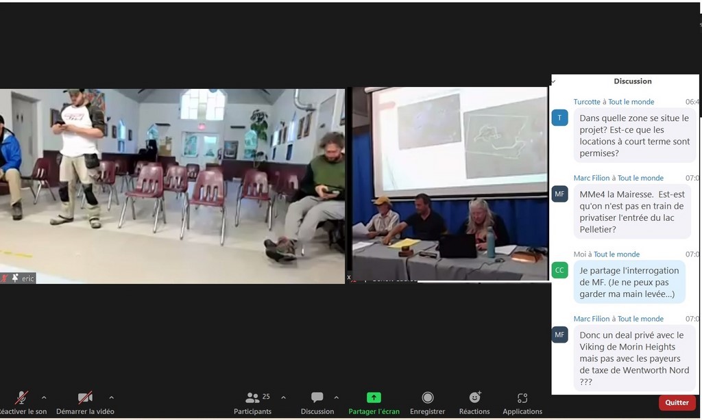
Doesn't it seem premature to lift the moratorium imposed by the Contrôle intérimaire on the lots concerned by this project, which could allow it to go ahead, before the May 11 consultation on the moratorium?
Since the reformulation of the Phase 2 project by its promoter implies a new analysis and acceptance by the Council, how could it ignore the modifications to the Urban Plan that should follow the work behind closed doors of the CCU, the municipal departments involved and the Council, as well as the May 11 consultation and those that would follow? Aren't the questions and criticisms raised by this project in particular at the heart of the reflection that must feed into the modification of the Urban Plan?
In its two phases, the Domaine du Mont project will determine the residential vocation of a vast area between Lac Saint-François-Xavier and Lac Notre-Dame, but without direct access to the latter, to Lac Saint-Victor or to the smaller accessory lakes.
The September 19, 2022 petition aimed, among other things, to prevent the realization of this phase 2 of the integrated project, to be served by the Lac-Thurson road. In the medium term, this phase called for the construction of several dozen rental properties on land sold to the developer by Lac St-Victor Estates. However, there has been no public assessment of the impact of a few hundred residents and visitors on the corresponding capacity of these nearby lakes.
Wouldn't these households necessarily be interested in frequenting the aforementioned lakes, and especially Lake Saint-François-Xavier, with its public access, if that weren't already the main reason for their coming to Domaine du Mont? Let's not forget the opinions expressed by several residents, in 2022, to the effect that we had not taken into account the definite impact of these projects on either the watershed of Lake Saint-François-Xavier, or on the increase in traffic in Montfort and the pressure on the small beach and boat launches in this lake, in the absence of similar possibilities in lakes Notre-Dame, Saint-Victor and other small lakes.
In 2022, we had already expressed the near certainty that the village of Montfort was not currently in a position to support this project. And that's not counting all the other considerations that are the subject of the current moratorium. But would the dozen or so years over which phase 2 of the project is scheduled to unfold leave enough time to see to that?
However, we mustn't underestimate the contribution such projects can make to the socio-economic development of Wentworth-Nord itself. The arguments for and against these integrated real estate projects are therefore in stark contrast, and the amendments to the Urban Plan will have to reconcile them. It is clear, however, that rapid changes are needed, in terms of both infrastructure and public perception, in the face of the real estate boom in the Montfort sector. Will the unveiling of the painting behind the current moratorium reveal a work of art commensurate with the expectations it has raised?
The May 1 consultation, perhaps due to a lack of questions on our part, did not allow us to learn more about the changes and implications concerning phase 2 of the Domaine du Mont project. But it seems to us that these consultations also usually call for questions or comments that can still be addressed to the administration and the Council. We do not know whether this draft by-law will be adopted at the May 15 Council meeting.
Without prejudice; by Carl Chapdelaine
Translated with www.DeepL.com/Translator (free version) & Linguee
Consultation of May 1, 2024, 6:30 p.m.


(Forestry in H-56 & Phase 2 of the Domaine du Mont Project)
All members of Council were mobilized for this consultation, as well as the General Manager, Mr. Ron Kelly, the Director of Urban Planning and Environmental Services, and the consultation leader, Mr. Benoît Cadieux, not to forget his Assistant Director Benjamin Plourde. Unfortunately, there were only two or three participants on Zoom* and none in the room at the Laurel Community Centre.
Bylaw project No. 2017-498-23, the 1st subject of this consultation, was adopted at item 8.5 of the April 17 council meeting. It aims to authorize the forestry use in zone H-56, and to define the minimum lot dimensions for this use. It is subject to referendum approval. Zone H-56 is located on either side of the Aerobic Corridor and Route Principale / Rue Tassé, at their intersection with Hydro-Québec high-voltage lines.
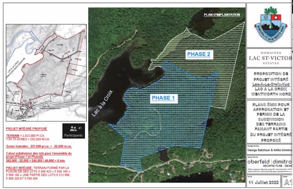
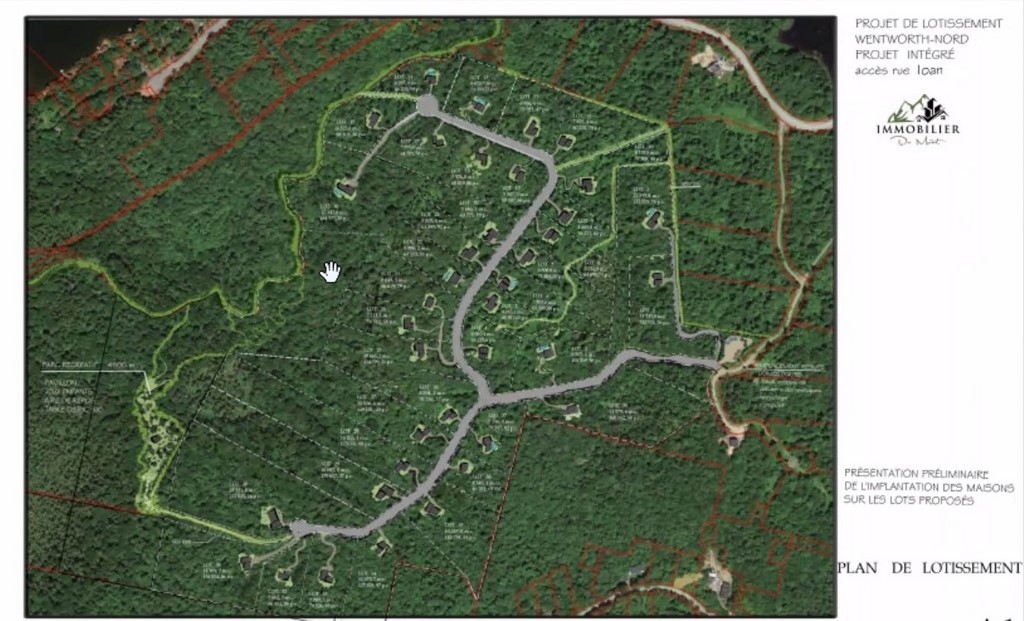
By-law No. 2022-608-4, which is the 2nd subject of this consultation, was also tabled at the council meeting of April 17, under item 8.4, with dispensation from reading. It includes, among other things, "a lifting of the prohibitions (prescribed by Interim Control) with regard to lots 6,547,078 and 6,530,075 of the Quebec cadastre in order to permit the realization of Phase II of the Domaine du Mont Integrated Housing Project"*. The map appended to the by-law delineates the territory of this Phase 2, west of chemin du Lac-Thurson and Phase 1. By comparison, it is three times the size of the latter, or several times the size of the Lake Saint-François-Xavier waterfront properties served by the new Rue des Érables.
The project, which looked set for completion in around fifteen years, was the subject of an information session held on August 10, 2022. Phase 2 could not be accepted, as the applicant did not yet own the land.
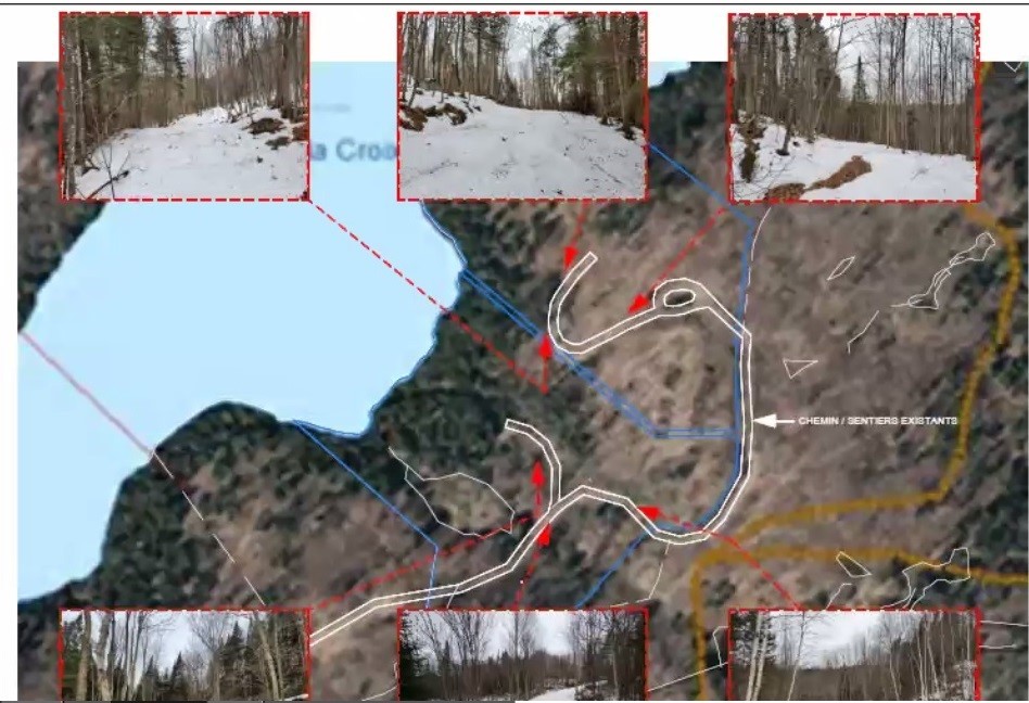
Since it was submitted to the CCU and Council, the Phase 2 project has been modified; it will therefore be subject to a new analysis and acceptance by the Council within the framework of the PIIA. Mr. Cadieux indicates that the question of the trails involved will be studied again.
We understand that the probable adoption of this by-law will make the project acceptable to the municipality. Then, the eventual issuance of the permit, if the project meets the PIIA criteria, would normally not be subject to any referendum process.
Note: As the dispensation from reading, accompanying the tabling of the draft of this by-law, has become the norm this year, the undersigned, like, no doubt, most of the participants in this last regular council meeting, had not noticed that one of the consultations would concern, in part, the Domaine du Mont project.
This real estate project had aroused a great deal of interest and concern when it was presented in 2022. A petition denouncing the ludicrous arrival of such integrated housing projects was even presented to the council. Unfortunately, the hyperlink for the Zoom, announced on our website, turned out to be empty; we apologize for this...
Without prejudice; by Carl Chapdelaine
*"Two Projects For Lake Saint-François-Xavier"
Translated with www.DeepL.com/Translator (free version) & Linguee
“More problems with the Montfort Pavilion”
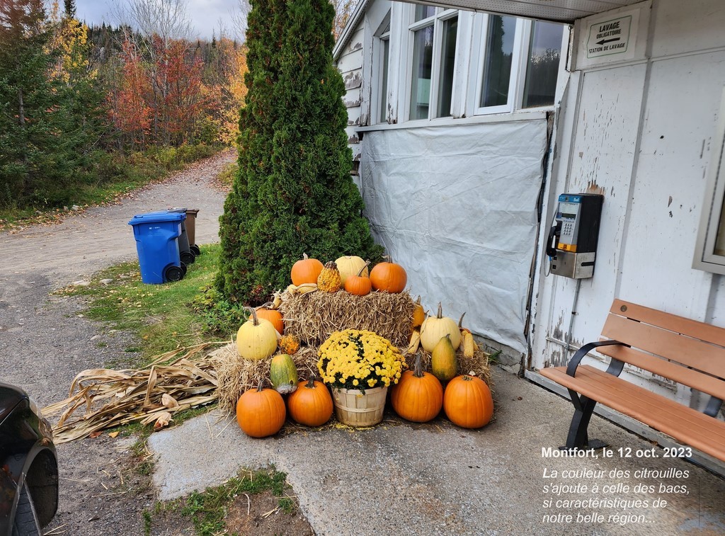
In an e-mail addressed to a number of residents, and while nothing transpires from the Advisory Committee's deliberations, the former councillor for District 5 in Wentworth-Nord, Mr. David Zgodzinski, on learning that the transaction for the purchase of the Montfort pavilion by the municipality has not been completed, reloads with his opposition to this project.
He intervened with the current councillor, Colleen Horan: “You told me that the municipality backed out of the deal because the MRC wanted more concessions from the municipality. Could you tell us what are all the concessions that the MRC demanded?
What is the municipality planning to do now? Is the council planning to counter offer or eventually to give in to increased demands from the MRC ?
In my opinion there are only a handful of us who would benefit from the municipality's plans for the Pavilion – there are the artists who would have the municipality pay for an art gallery where they can conduct their business, and there is a small group of residents who would like a meeting space to gather for coffee.
The few people who would benefit from keeping the Pavilion tend to volunteer for committees and their viewpoints are disproportionately represented.
…
I believe a large majority of residents would prefer to let the MRC keep the Pavilion. I believe a large majority of residents want the municipality to concentrate on protecting the lake and the residents. They want the municipality to spend taxpayer money on the vital needs to repair and maintain roads and other infrastructure. They would prefer to let the MRC pay for the Pavilion that they own ...
It's important to all of us to be informed about what is happening with the deal with the MRC.
What is your opinion? Are you still in favour of buying the Pavilion? Can you give us an update?”
Par Carl Chapdelaine
Montfort pavilion at the PTI
Newaygo Bridge For Cyclists!
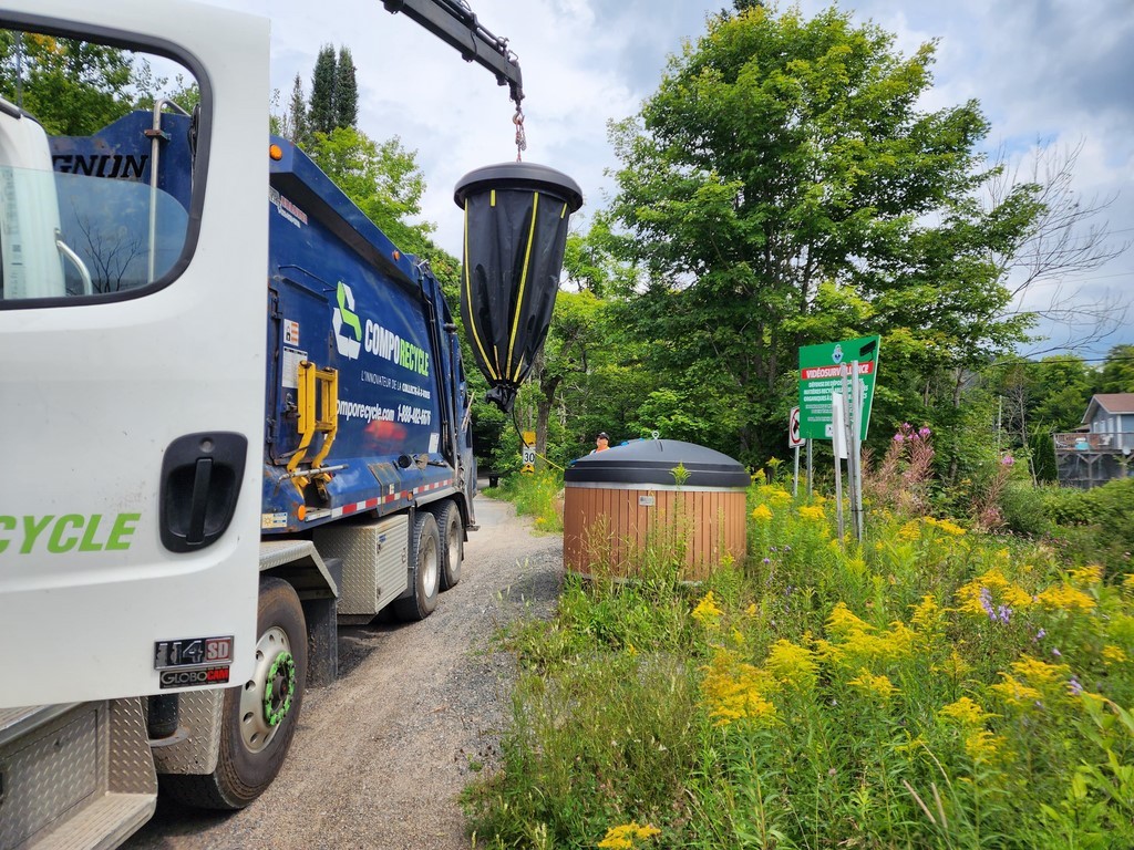
Semi-buried bin emptying
Consultation of July 26, 2023: 1. Land swap with Lac St.Victor E. 2. Pavilion
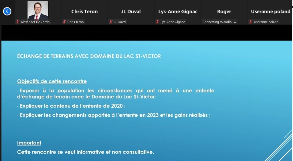
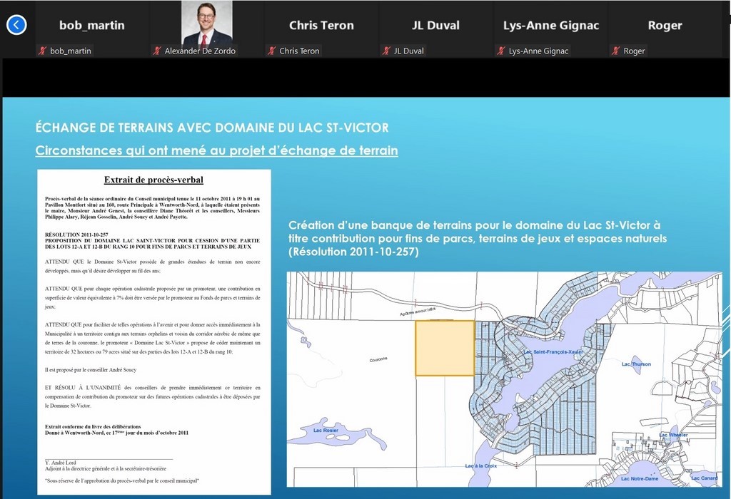
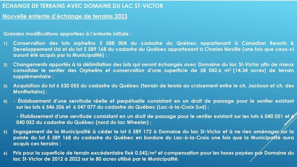
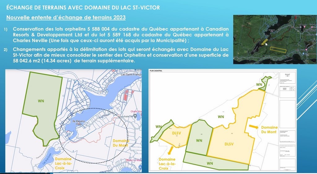
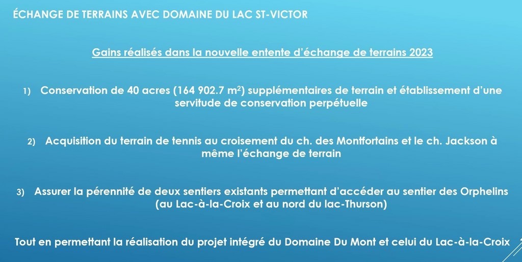
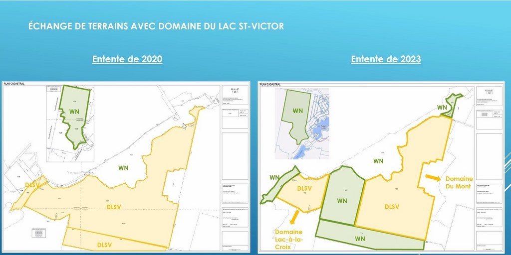
The plates in Mr. Cadieux's presentation give a good description of these land exchanges, mainly west of Lake St. François-Xavier, and show the complexity of the administrative measures involved.
(Here is our summary of the operation).
The Director of Urban Planning Services recalls that the route of the Orphans' Trail was at the heart of initial concerns about the ownership and zoning of the land involved. The cadastral revision would further multiply the number of modifications to be considered.
The accumulation of land in the bank of land reserved for recreational purposes, via the 7% required at the time of a subdivision, would be one of the instruments available to the municipality in the game of these exchanges.
The Du Mont project, phases 1 and 2 (to come), also required certain land exchanges between the municipality and Lac St. Victor Estates. The continuity of existing or future trails, to join the Orphans trail, dictated the choice of some of these exchanges.
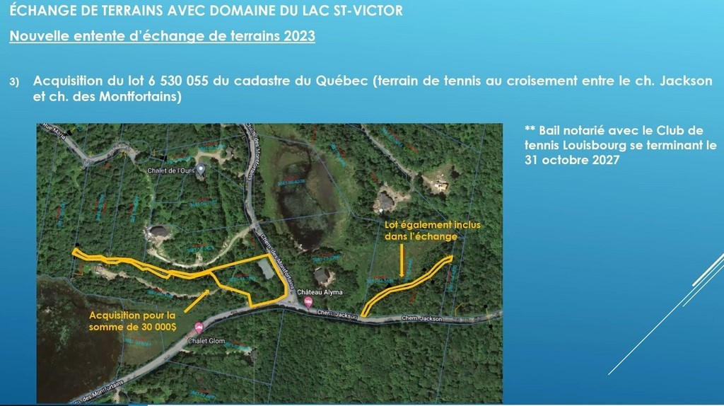
There is also a tennis court.
Question period (To summarize. For questions from the floor, inaudible, we interpret them according to the answers).
Concern was expressed about potential access to Lac Saint-François-Xavier by residents of Lac à la Croix and the new projects on chemin du Lac-Thurson. In response, we have done our utmost to limit non-resident access to the lakes.
The tennis court, like the protected trails, will be used mainly by residents. A resident reports vandalism by visitors to the tennis court on chemin des Montfortains. (?) We want to municipalize tennis courts in the area. (?)
Explanations are requested on the process, etc., of these land exchanges.
Snowshoe trails at Lac à la Croix will no longer be in the public domain and could lose their vocation.
In view of climate change and its potential impact on the lake environment or slope erosion, Mr. Cadieux and the mayor indicate that more stringent protection measures are planned, for example for roads in the lake environment.
A resident raised the issue of short-term rentals for the Du Mont projects. Out of order...
This consultation was the second part of the July 26 consultation, the first of which dealt with land exchanges between the municipality and Lac-St-Victor Estates.
Our report will be supplemented by a few comments from one of the project's opponents, the undersigned.
The mayor will present the consultation on the purchase of the Montfort Pavilion. The Power Point gives the essential information she will be transmitting. At the suggestion of Mrs. Denyse Pinsonneault, the meeting will be recorded; the Council will decide whether to broadcast it.
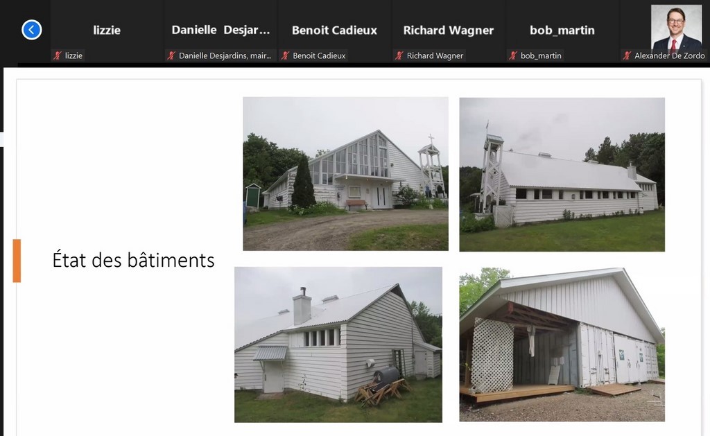
Ms. Desjardins begins with a brief history of the Pavilion and its successive managers. She then presented the state of deterioration (photos) and notes the absence of a definite restoration project by its owner (or manager?), the MRC.
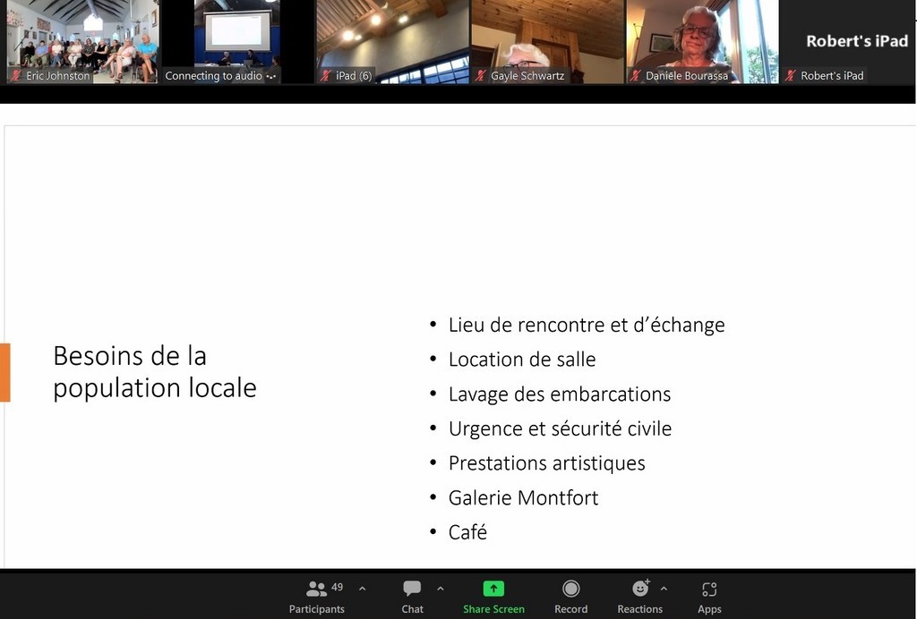
The fact sheet on the needs of the local population announces the options that will guide the conversion of the Pavilion.
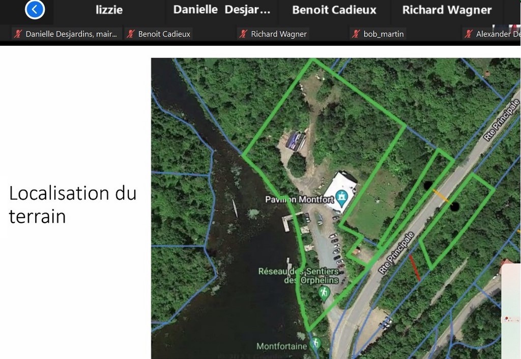
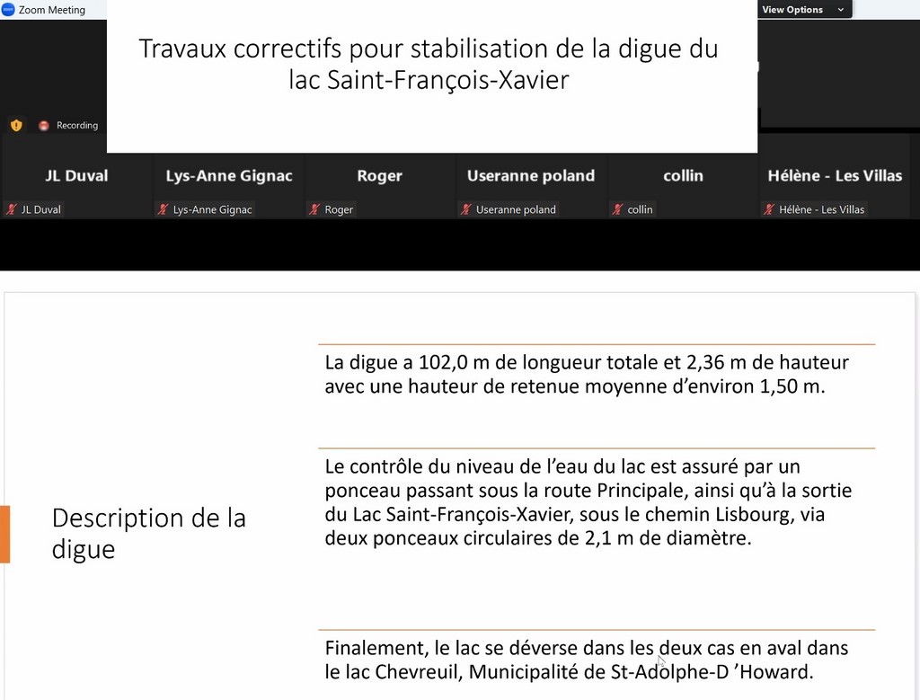
The fact sheet on the location of the land and the mayor's comments show that the portion of the dike on land currently managed by the MRC will be part of the transaction. (Currently, the MRC pays 60% of the cost of maintaining or repairing this century-old dike; in future, the municipality will pay 100%, as opposed to the current 40%. More than the purchase of the Pavilion, and even if it's not really the subject of this consultation, the purchase of the dike seems to us to be far more substantial).
The MRC, we learn, intends to put the Pavilion up for sale anyway. (But who would want to buy the whole thing, especially with the conditions they'd be putting on it; and would the dike be part of the sale? It's zoned recreational," says the mayor. Saint-Adolphe-d'Howard, perhaps, for its residents of Lac Chevreuils and subdivisions throughout the neighboring Montfort sector? And to exercise control over the dike that overhangs its lake by an impressive forty meters?
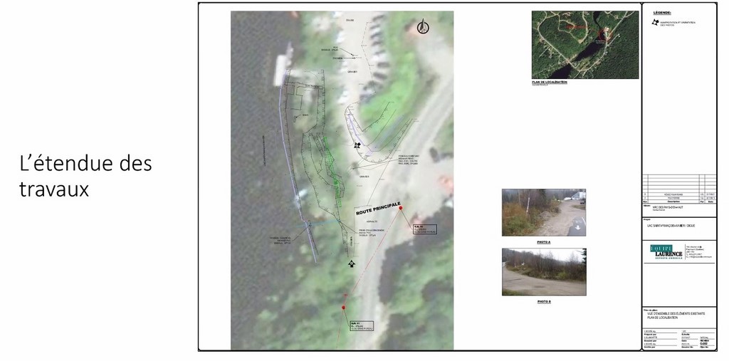
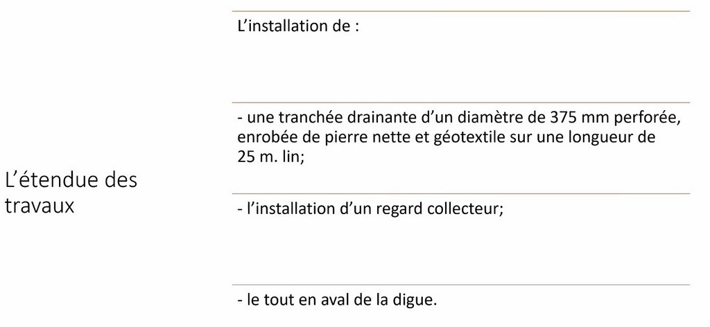
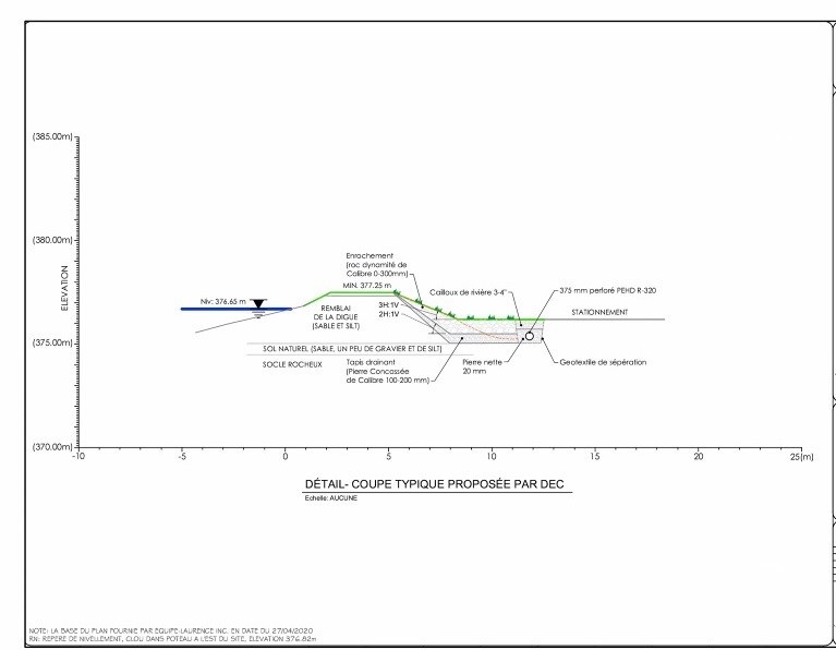
The fact sheets on the remedial work to "stabilize" the dike give us a description of the dike, the extent of the work required and its nature (presented by the engineering firm Équipe Laurence), i.e. "the installation of a drainage trench... and a collecting pipe" downstream of the structure. Water seepage through the dike and sinkholes on the access road to the Pavilion had been noted shortly after the removal of the railroad sleeper shield on the upstream face of the dam.
A sketch of the dam shows that it is made of sand and silt (a granular material between sand and clay in size). The work would cost between $50,000 and $60,000, with a contribution from the government, we understand. (There is no indication as to the lifespan of such a structure.) In response to our question, Mr. Aubé asserts that the heart of the dike is in excellent condition.
"A well-designed, well-built and well-maintained dike can easily operate for a century. But many structures around the world do not meet these criteria." Les barrages qui vieillissent ...)
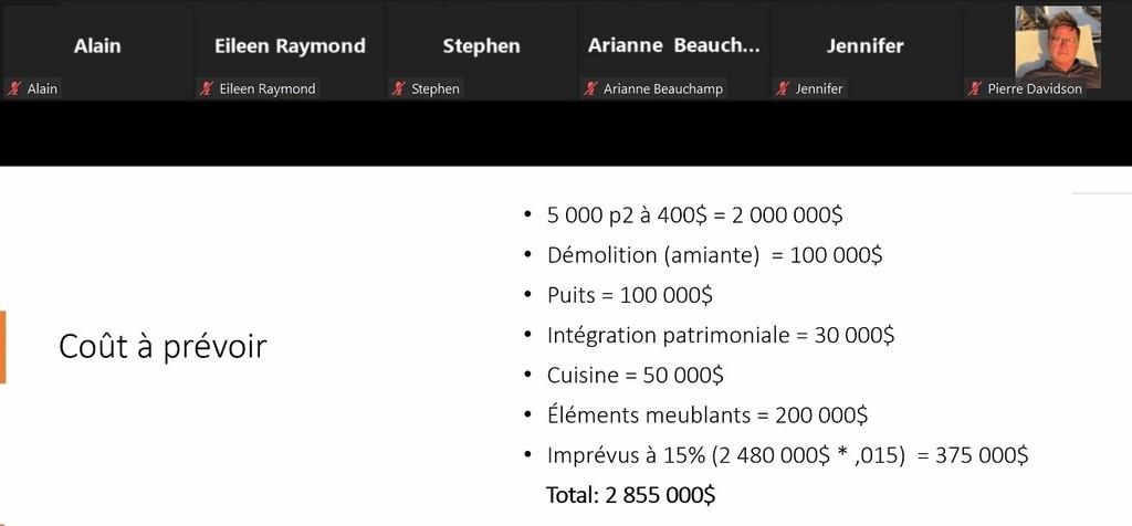
Finally, a sheet calculates the costs to be expected, which amount to nearly $3M. (But for which scenario exactly? And that's not counting future maintenance and other costs, depending on the options chosen by the Advisory Committee). The mayor will point out that we'll have to make the investment profitable. (Really?)
.....
The majority of interventions would have been in favor of purchasing the Pavilion (and the dike...) (certainly in favor of the provision of a multi-purpose community center and other perceived advantages), and in favor of keeping the MRC out of it.
The question from former councillor David Zgodzinski, opposed to this transaction and which he had sent to council members, with a request to present it at the consultation, was not mentioned...:
"Bonjour Mme. Desjardins,
I will not be able to attend the meeting on Wednesday. So I'm sending you this question via email.
What arrangements or contract does the municipality currently have vis a vis the MRC's free tourist business in Montfort? What are the proposals for the management of these activities going forward?
It's vital for the residents of this area to know how this will be handled with your proposed project for the Pavilion.
Merci,
Dave "
The undersigned's question:
1. (On pro-forma balance sheets on the transaction, based on options to be defined by the Advisory Committee, got the answer that the latter would know how to do things right.)
a. "Shouldn't your advisory committee choose the options for the future Pavilion before the municipality decides to complete this transaction?
b. Wouldn't a pro-forma budget based on the options considered for the Pavilion's future be a prerequisite for this purchase?
c. Given all these options, won't the budget be your committee's main advisor?
Reply from D. Desjardins (roughly)
The advisory committee is there to see to everything.
The budget will not be part of the advisory committee... "
2. On the dike (on Zoom): "You have a project to install a collecting pipe, but in the longer term, isn't there a risk of more extensive work? You'll still be the owners.
Reply from Mr. Aubé: "The heart of the dike is solid."
D.D. "We already own the dam (jointly with the MRC), and we know how to take care of it."
Mr. Christophe Guy: The cost of repairing the Pavilion... Why another building? Ans. D.D.: It's not a functional center. We need a center in Montfort, like Laurel and Saint-Michel. During construction or reconstruction, we may be able to set up something temporary.
A woman in the audience: (On the conditions requested by the MRC...) "We're concerned about visitors to Lake Saint-François-Xavier. We don't want to have everyone on our beautiful lake..." Response from D.D.: Users wash their boats themselves. ... It doesn't cost them anything. We must make the Pavilion profitable.
X: What if it's another buyer? D.D.: Don't know... It's zoned recreational. E. Johnston: Every possible measure has been taken in recent years to protect the lake.
Ms. Trish Canty (Viking Club): What's going to happen to us when you own the property? What about our containers? (?) We don't want to have to tear down what we've built. We don't rent boats; they're for our members and customers. (Response not noted.)
Mme Denyse Pinsonneault :
- Why do we have to offer universal access to our sanitary facilities? D.D. We don't have to. (?)
- Why are boat washes, etc., free? D.D.: At Parc de la Doncaster, you have to pay. Lac Saint-François-Xavier is at risk.
- There's never a parking space free for us.
- Will we be masters of our own home? D.D.: We currently pay 40%, and we can't decide anything.
Ms Diana Jegou (inaudible) Ans. from D.D.: Possibly close the two parking lots on the Corridor, in Montfort.
Ms. Jennifer: How do you know that people wash their boats? Everything should be reserved for us. D.D. They sign the register. We've acquired an (automatic) washing station, which issues the certificate. There will be fences, and the certificate will allow them to be opened for the period indicated.
Resident: In Newaygo, many visitors have free access to the lake. There are no controls. The gate doesn't work.
Mr. Y: Can we have the report that was produced on the dike? D.D.: It's in the hands of the MRC. You can request access to the information.
The mayor: We paid $100,000 when we managed the Pavilion (which doesn't belong to us)!
Mr. Yves Léveillé (inaudible)
Mrs. Z: The MRC will continue to manage the Aerobic Corridor...
Mr. David Clark (inaudible) Rep. D.D.: The board and administration will analyze the comments... E. J.: Perhaps another...
Mr. Christophe Guy:
- The Pavilion is all we have left in Montfort... Otherwise, Morin-Heights is closer than Laurel.
- All the lakes belong to Quebecers.
The Pavillon, a regional socio-cultural and recreational center
In our opinion, whether municipal or mandated by the MRC, the Montfort Pavilion, or the new building that could replace it, will have to meet the needs of both residents and visitors who legitimately aspire to enjoy the Aerobic Corridor or Lake Saint-François-Xavier. It cannot become the watchtower of a fortified village. Otherwise, the state of neglect into which it is sinking today, under the sad gaze of those who have contributed so much to its survival, can only result in an enlargement of the adjoining cemetery grounds.
This regional duty is already announced in one of the whereas of the offer to purchase resolution adopted by the municipal council: "That the municipality wishes to associate a regional vocation with the Pavilion, via an administrative agreement with the MRC." Doesn't this preamble render illusory the idea that, under municipal ownership, the municipality and residents of Montfort could manage the center entirely as they wish and exercise full control over its use and its role in welcoming visitors? On the other hand, wouldn't they have to pay all the costs associated with purchasing and maintaining their property?
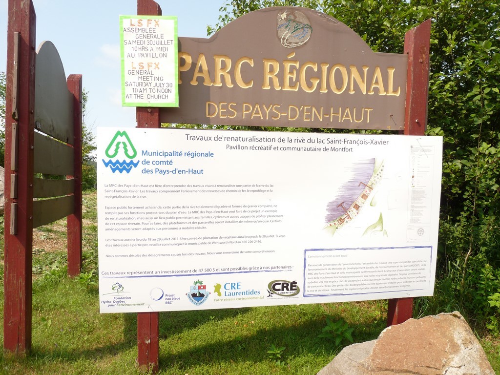
In our view, the most appropriate solution for this center is one of balance, albeit one yet to be defined, even if we seem to have moved a long way away from it today. This is the approach taken by the authorities in certain tourist areas that have become too popular: we don't ban tourism; we regulate it. One day, it will have to be admitted that residents and visitors will always have to coexist on Lake Saint-François-Xavier as well as on the Corridor. Fortunately, these activities, within the current framework of a regional park, do little harm to the environment of these two jewels, apart from the fear of introducing invasive species.
It would have been better to rework the formula initiated before the pitched battles over the Newaygo bridge, the Corridor shared lane and the proposed purchase of the Pavilion by the municipality. Set quotas for visitors to the lake, using a vignette or reservation system, and monitor parking. Maintain the rental of nautical equipment, and if possible, prohibit all other watercraft, thus guarding against the threat of contamination. Ensure compliance with regulations. Work to develop specific rules for cohabitation on the Aerobic Corridor; etc. Conflicts cannot be resolved by entrenching oneself in one's position, by asserting one's rights, or by the law of the strongest. You only amplify them.
A community center is not intended to be financially profitable. The Montfort center, which will inevitably be solicited by outside customers - and even if ordinary citizens don't have access to the financial data attributed to it - will only generate a recurring deficit. But why would the municipality want to take on such an undertaking on its own? Why not leave it, as at present, to the MRC and the government? And would a change in power at the next municipal elections mean a further step backwards?
Even if the management formula dictated by the MRC for both the Pavilion and the Corridor may run counter to residents' aspirations or restrict their property rights, and sometimes harm their environment, don't residents derive some benefit from the fact that they are public property?
Such a balance obviously requires a closer relationship between the municipality and the MRC. But what of these discussions, behind closed doors, between two councils, yet made up of elected representatives whom their citizens have deemed respectable? The image of the MRC in Montfort is not good; it is even becoming perceived as the source of all ills. Between the mayor, the mayoress, the Wentworth-Nord councillors and the prefect, alliances seem to be made and broken according to elections, ideas, and moods. Doesn't the citizen, who can only see the back of the deck of cards held by his or her elected representatives, have a right to less conflict and more respect?
Translated with www.DeepL.com/Translator (free version) & Linguee
By Carl Chapdelaine
Public consultation on the purchase of the Montfort Pavilion
On Wednesday, July 26, the municipality of Wentworth-Nord will be holding a public consultation on the purchase of the Montfort Pavilion, to hear residents' opinions and questions about this controversial project. However, at its last regular meeting, the council already passed a majority resolution to present a final offer to the MRC, in the amount of $1, for the sale of the building and certain other assets, the details of which we don't have. So, where does this leave us? And how can we find out the position and intentions of the MRC, the eternal absentee from these consultations, as if this were not a factor?
It seems clear that the district's residents, accustomed to enjoying certain services offered by the Montfort Pavilion in good years, despite its sometimes-bumpy management, want a better future, or one more exclusively at their service, than what we know today for this socio-recreational-cultural center or its eventual replacement. Didn't the executive of the Association du lac Saint-François-Xavier recently inform us that their organization would have to hold its 2023 annual general meeting in Morin-Heights rather than at the Pavilion, because its use had been refused?
But it's the acquisition of the assets involved, which are already public, the cost and risks of the operation in the short and long term, the alternatives, and the design of such a future socio-community center, that are raising questions, particularly those of the previous councillor for district 5, Mr. David Zgodzinski. In a somewhat mocking tone, he renewed his warning about the transaction. How can you be for or against something you know little about? Before asking our opinion, shouldn't we be enlightened on all the aspects of such a transaction, which has already begun?
Well, not all aspects since residents are divided on the choice of clientele for the future center. Will it, as before, be for the use of visitors from all over as well as residents, as one of the whereas of the council's resolution seems to indicate; or will its design respond solely to residents' interests and fears for their environment, as Mr. Zgodzinski seems to wish? It may well be that the conditions imposed by the MRC on such a transfer of ownership will reflect the maintenance of visitor facilities, with all that this implies in terms of parking, responsibilities, management, access to the lake and so on. Conditions that risk nullifying the advantages, but not the disadvantages, of municipal ownership.
The cost of converting a church into a community center or building a new one with essential services seems to vary between one and a few million dollars. Building a new, multi-purpose building can run into the tens of millions. Several municipalities, large and small, have taken the plunge, but it's often a matter of buying back a church from the parish council, or transforming a municipal building that has become obsolete.
The government, through its Réfection et construction des infrastructures municipales (RÉCIM) program, among others, was often generous in subsidizing such municipal projects, and could be expected to cover 80% of the construction cost. This assistance will be replaced by the Programme d’amélioration et de construction d’infrastructures municipales (PRACIM). But annual fees can represent a significant expense for the municipality. In the case of the Montfort Pavilion, the transaction equation is infinitely more complex.
The municipality's responses, and the objections of those opposed to the acquisition, may not change the way anyone sees the purchase of such a center and its use; but they may, at least, put their arguments on a better footing.
Examples :
- Un centre communautaire de 1,2 M$ à Saint-Eugène
- Franquelin bénéficiera d’une aide financière de 1 118 950 $ du gouvernement du Québec à son important projet d’aménagement d’un bâtiment communautaire polyvalent et intergénérationnel au coût de 1,6 M$. Le ministère des Affaires municipales et de l’Habitation vient de confirmer son soutien par l’entremise de son programme Réfection et construction des infrastructures municipales. Son apport couvre près de 70 % de l’investissement requis. https://www.lemanic.ca/2019/10/25/centre-communautaire-quebec-accorde-une-aide-de-11-m-a-franquelin/
- Notre église, un outil de développement communautaire
A revamped Pavilion?
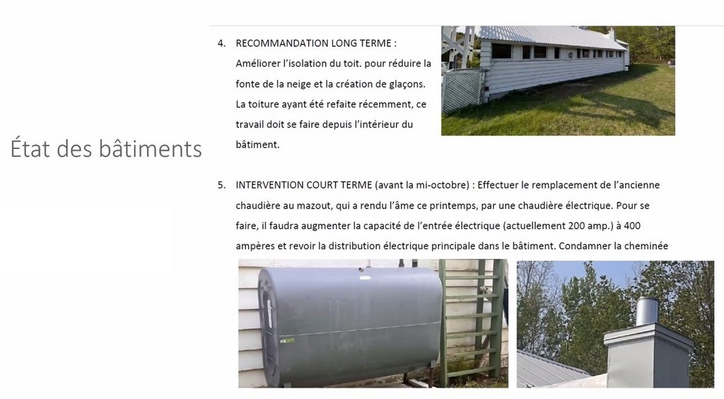
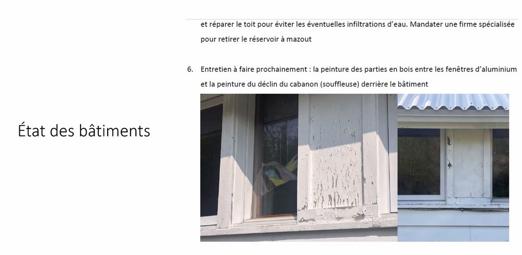
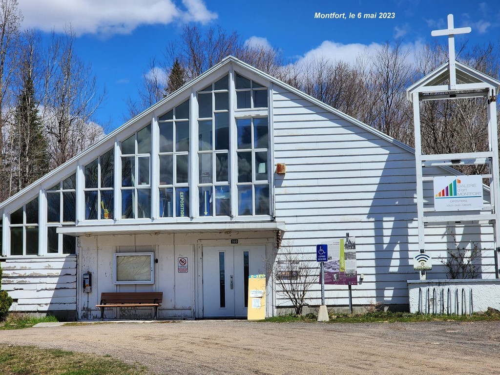
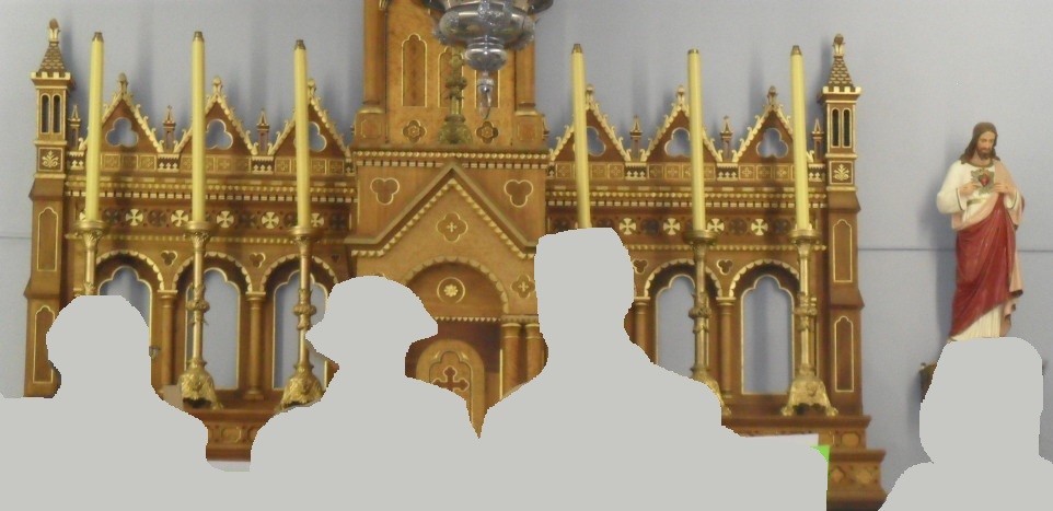
Montfort's former church doesn't look like much. Is it simply the fact that its siding is in a state of disrepair; its Marian blue is left to the whim of the sky, and the beautiful statue of the Blessed Virgin has disappeared; its bell tower has been emptied of its bells; a telephone is flanking its façade as a holy-water font; its sad notice board displays municipal notices, rather than Mass schedules; its surroundings are used for all sorts of disparate purposes; the environment is unkempt; etc.? As a heritage building, we can imagine better...
Without being an architect or other building specialist to evaluate the renovations, the new interior fittings, the upgrading of its rood screen, etc., or the costs associated with them, we can imagine, if it's true that its foundation is still good, that there is a way to rehabilitate everything between it and a roof that has already been renovated.
And if the interior shouldn't be restored to its original condition, why should the exterior? If the investment were worth it, why not, while preserving its unique character as a visual symbol of the village itself, give it an up-to-date makeover? With a sizeable budget, we could even imagine something inspired by the jewel in the crown of Saint-Michel church, its counterpart at the other end of the municipality.
The cemetery, the last faithful member of this Notre-Dame-des-Nations and an icon of heritage, will have to accompany either the old or a new structure. But doesn't it also deserve some attention from its owner, whoever that may be? If we've been able to create an impressive Calvary in Huberdeau, can't we imagine a design that recalls the memory of the Montfort settlers? And should Saint-Adolphe-d'Howard, with its cemetery transformed into a beautiful park and its moving monument to the Montfortains, the Filles de la Sagesse and the orphans, be left alone to remember the Lisbourg orphanage?
In our opinion, neither the restoration of the current building, nor the construction of a new community center on the same site or elsewhere, could be justified or profitable without the full return of the activities, apart from worship, that made this pavilion's heyday, with, what's more, a notable attendance going beyond local users.
It will have to become the Montfort stage of the Aerobic Corridor Park. For the latter, whose recreational function is currently only possible in Montfort during the summer season, we'll have to come up with a real link that will enable the most intrepid skiers to complete the 58 km that will take them to Lac-des-Seize-Isles and as far as Lac Rémi (Amherst). Or enjoy a circuit using the Sentier des Orphelins, rather than venturing down the latter from Newaygo and ending up in a dead end.
Have corn roasts, Christmas markets, potlucks and Echo Aloha's paddleboard tribulations gone out of fashion? Or is it the decline of the venue, the dismissal of the reception staff, the disappearance of the coffee counter and the closures that explain the drop in attendance? Will these activities be reborn, alongside a proud Galerie Montfort, with the restoration and improvement of the Pavilion’s visitor conditions, or the construction of a new community center?
Looking back is essential, but not as essential as looking ahead. Will we agree to see and greet visitors again, as we ourselves would like to be elsewhere; to rub shoulders with cyclists who are better directed or who benefit from a separate lane; to allow standup paddleboarders and kayakers to navigate in dedicated lanes on the lake? Should we insist, as we do now, on destroying everything, when earlier we were striving to find ways for visitors and residents to coexist?
Wouldn't it be better to improve the management of the lake attendance and of the Aerobic Corridor shared-use path, by means of an efficient reservation and vignette system, or otherwise, rather than imagining encircling the village with a rampart against all invaders?
With integrated rental projects on the horizon and an increasing number of residents, aren't the constraints of the future already mapped out? But who today would take up the torch of such an adventure: the MRC, the Municipality, the Lake Association? For its part, the municipality has set up its Comité temporaire du pavillon Montfort, chaired by the mayor; but we don't otherwise know its composition.
Translated with www.DeepL.com/Translator (free version)
By Carl Chapdelaine
Du Mont project, phase 2
The September 19, 2022 petition aimed, among other things, to prevent the completion of phase 2 of the integrated Du Mont project, to be served by chemin du Lac-Thurson. In the medium term, this phase involved the construction of several dozen rental properties on land sold to the developer by Lac St-Victor Estates.
The initiators of the petition* are today inviting their supporters to express their opposition once again to this project to the Wentworth-Nord council, and to monitor any decisions it may make at this Friday's special meeting, which includes this item on the agenda.
The message from these initiators recalls that Councillor E. Johnston, now on sick leave, had requested that a whereas of the resolution under item 8.20 of the agenda of the regular meeting of May 17, dealing with the municipality's involvement in this file, be withdrawn from the resolution. At the mayor's request, the entire resolution was postponed, and will probably be the subject of Friday's special meeting.
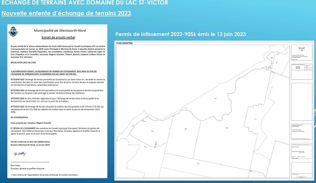
The authorization, at the May 17 meeting, of "the issuance of subdivision permit 2022-9056 for the exchange of land with Lac St-Victor Estates." had alerted the petitioners to the progress of the file.
The undersigned understands, from the sense of urgency contained in the message from the petition's initiators, that it would be appropriate to forward one’s position to Council before Friday's special meeting.
It is to be hoped that, in any case, Council will make clear on Friday the implications for phase 2 of the Du Mont project of the land swap with Lac St-Victor Estates which is the subject of this meeting's agenda item. In any case, the questions will not affect the decisions adopted by the Council at that time.
By Carl Chapdelaine
* dturcotte90@gmail.com chris@teron.ca
Translated with www.DeepL.com/Translator (free version) & Linguee
Is The future of the Montfort Pavilion sealed? (Opinion)
This community center and, to this day, stopover on the Aerobic Corridor and place of worship, with its entry in the Répertoire du patrimoine culturel du Québec*, is now but a shadow of its former self.
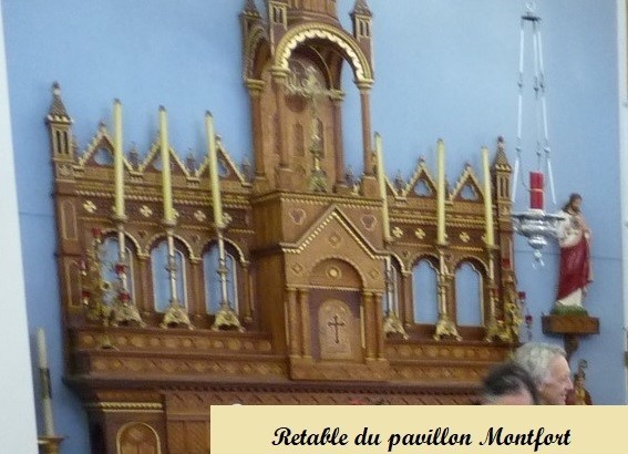
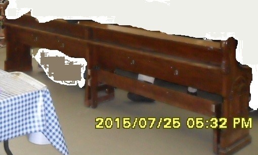
Worship will no longer be practised there, while the last vestiges of the Montfort orphanage chapel - pews and altarpiece - are being scattered to the four winds. If the MRC planned to retain ownership and maintain its status as a real-estate heritage site, couldn't it have purchased the pews for sale for $150 each, as well as the altarpiece, which should go to Saint-Sauveur?
But since the municipality is in negotiations to acquire the building from the MRC, without knowing whether it will be renovated and transformed or demolished, the concept of the building's immediate future, as well as its management and activities, are in jeopardy.
Should we now forget the past of Montfort and its orphanage; or should we, one day, return to it: tracking down buyers of pews where possible and offering them top dollar to buy back a few; recreating a semblance of a chapel in a renovated building or in a corner of a new structure, to repatriate the altarpiece and statues? Or entrust such an operation to photographic and virtual memory alone?
Today, we're beginning to think that the land where the Pavilion is located, in the middle of the Parc régional des Pays-d'en-Haut, might be more valuable than the Pavilion itself; that the municipality could build a new community center there, adapted to the needs of the residents - some two hundred permanent residents and a few more cottagers, most of them seasonal.
A refuge in case of disaster? If the dike is washed away, the future center could be, too... With the lake at the head of the watershed, the risk of major flooding due to some storm does not attract much attention. Power failure? Ah, yes! The center will have to be equipped with a generator, emergency beds and equipment, an artesian well, a stockpile of consumer goods, a foolproof heating system, all electronic or communication facilities, etc., and benches perhaps...
But whatever the value of the Pavilion or the land, don't they already belong to us? Aren't we in a battle similar to that between sovereignists and federalists? Does the Pavilion (Quebec) belong to us or not? Why didn't we hold a first referendum on the question, perhaps with the promise of a second, to try to reverse the results of the first?
Isn't a bird in the hand better than two in the bush? What will the MRC lose, and what will Wentworth-Nord gain? Will the municipality have to pay for the destruction of the Pavilion it purchased? Why not let the MRC take care of it? Couldn't our municipal councillors, in Laurel or Sainte-Adèle, turn back the clock, put their disagreements aside and define together, with the approval of citizens and financial experts alike, what's best for everyone?
By Carl Chapdelaine
*patrimoine-culturel.gouv.qc.ca
Other link : corridoraerobique.ca/a-propos/
Translated with www.DeepL.com/Translator (free version) & Linguee
Church pews for sale
When will there be a movie about the future of Montfort Pavilion? Crime novels have fallen out of favor, preferring science-fiction movies starring half-human, half-monster characters created by computer. But at Montfort, we have all the elements to feed the suspense; the future of the Aerobic Corridor and the Montfort Pavilion are golden subjects. Residents are kept on their toes. But why worry? In the ring, our municipal officials, those of the MRC, two new committees, one on the Aerobic Corridor, one on the Pavilion, are debating and keeping an eye on things!
At the last news, during the council of mayors, we were presented with alternatives on the future of the Pavilion: the MRC will give it to the municipality, if it still wants it and under certain conditions; or there will be no future. For the moment, we are straddling the fence, we discuss and improvise...
In the meantime, many activities were put aside last winter; the furnace blew up at Easter. The toilets are in bad shape, like the rest of the building. The rood screen is not safe for exhibitions. And so on. And now a simple note on posted paper indicates that the pews are for sale; that the Pavilion is no longer a place of worship. And the hotel or other religious accessories? Will only the stained-glass windows remain for the last faithful to make their way of the cross? Couldn't we have kept a few pews and made the rood screen into a last chapel?
Fortunately, the municipality has just created a "Demolition Committee", which will ensure the preservation of Nord-Wenwortois heritage buildings, if any remain... We were looking for the appropriateness of such a name; perhaps this is the explanation. The cost of the necessary renovations was rounded up to $1 million. We will have to adjust the bill; not to mention the possible purchase of new benches or chairs if the Pavilion ever becomes a community pavilion, a performance hall, a multidisciplinary service center. But all of this can be planned once we have cleaned up and developed the budget following a call for projects.
The residents of Montfort are mere spectators in this serial novel. What will be next, by human hands or by force of the elements? There will still have to be an entrance fee, in the form of huge loans and taxes for all citizens; those of Wentworth-Nord alone, as proposed, or as part of those of the MRC. Perhaps, as the late mayor Jean Drapeau used to say for the financing of the Montreal Olympics, "We just need to let the water flow in the bathtub"; and perhaps Mayor Valérie Plante could help us track down this miraculous bathtub.
Should we applaud right away, or wait until after the show?
Translated with www.DeepL.com/Translator (free version) & Linguee
By Carl Chapdelaine
Real estate: petition vs. moratorium
It should be remembered that a group from Lake Notre-Dame circulated a petition* last September, mainly concerning "the integrated residential development projects in Lac-à-la-Croix and Dumont and the mechanisms for informing residents about major projects such as this one, which have impacts on the environment, traffic and the quietness of the area.”
The petition was filed with the city council on September 19, after collecting over two hundred signatures. However, the council had anticipated this filing by convening a special meeting on September 17, by which it adopted a process of "interim control" in order to temporarily stop these categories of future or not yet approved real estate projects on its territory.
The authors of the petition are now issuing an update on the reception or follow-up given by the municipality to their demands. They mention, among other things, the holding of a meeting, on December 5, via Zoom, organized by the executive of the Lac Notre-Dame property owners' association, on development issues in their sector. The meeting was attended by members of the executive, the five organizers of the petition, as well as the two elected officials of the sector, Mayor Danielle Desjardins and District 6 Councillor Eric Johnston.
The email information provides details on many aspects of their requests and Council's reactions, but it is worth noting that the only responses they have received "lead us to believe that we have made little progress since the petition was filed last September". And that: "To date, the City Council does not seem to have taken into account these aspects that we believe are unavoidable.”
For the future: "We believe that it is still possible to put pressure on City Council to back down in the short term on the adoption of phase 2 of the Dumont project and that in the longer term it works on a more global vision of development projects as well as on greater use of consultation mechanisms on these projects.”
*Petition and moratorium on real estate development
By Carl Chapdelaine
Translated with www.DeepL.com/Translator (free version) & Linguee
François Froidevaux and the Montfort Colonization Railway
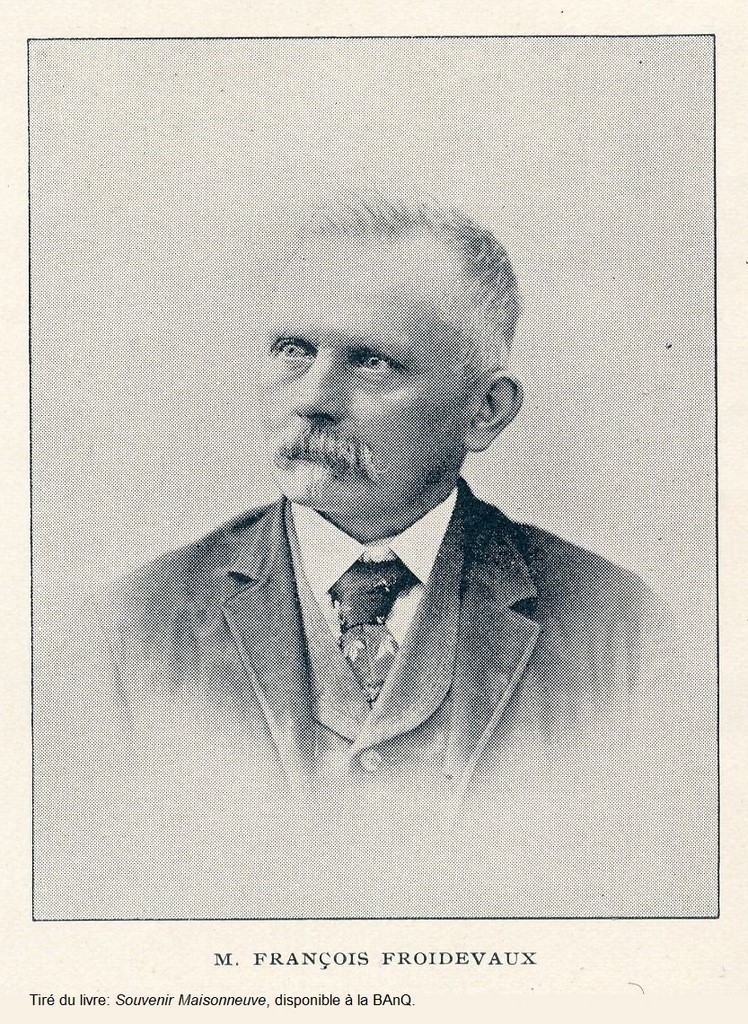


Mrs. Sylvie Allard, whose great-great-grandfather's name was François Xavier Farez, said Froidevaux, sent us a copy of the contract* signed between her grandfather and the Compagnie de Chemin de fer de Colonisation de Montfort, for the construction of the last section of this line "from its present terminus" (it must be the village of Lac-des-Seize-Îles) to the river called "La Rouge", in the township of Arundel, "a distance of about sixteen and a half miles".
Mr. Froidevaux, who came from Switzerland with his family in 1869, lived in Montreal. At the end of 1880 - beginning of 1881, this blacksmith and master plumber would be one of the prominent figures of a group of citizens of this city who wanted to contribute to the work of colonization initiated by Curé Labelle by "(acquiring) each one a lot or two in some township of the North".
(Orphelinats agricoles de Notre-Dame de Montfort; The origines of Montfort) We will guess here below why the name of the lake Saint-François-Xavier could have been attributed to him, according to the indication of Tourisme Laurentides (But there were several personalities bearing this first name at the time and involved in the same movement...) Froidevaux Township, in the Laurentians, also bears his name.
Where would they buy?" was the first question asked... three of them, the most daring, Messrs. Froidevaux, Brochoud and (François-Xavier) Montmarquet (the first two, mountain dwellers by birth) ventured into the forest, and, after various errands and explorations in the neighboring townships, where their idea had not been able to settle, they penetrated into the northern part of the township of Wentworth, in the eleventh range, through the thickness of the woods, without any roads ... and arrived near the place where the mill and the first orphanage are now built." "On their return to the city, they reported accordingly to their companions gathered one evening in the blacksmith shop of one of them." It was, of course, the workshop of Mr. Froidevaux, as Mrs. Allard will point out.
It was in this humble workshop, at 264 Saint-Laurent Street that, in a way, the face of a new parish and eventually of the newborn village of Montfort would take shape. It was there that it would also be defined, in response to the wishes of Father Rousselot, then pastor of Notre-Dame in Montreal, the concept of his orphanage. This "kind of association" of citizens for the good cause will be at the origin of the committee of the provisional organizers of the agricultural orphanages, of which the abbot was recognized as president by right. The Montfort Agricultural Orphanage was officially inaugurated on September 17, 1883.
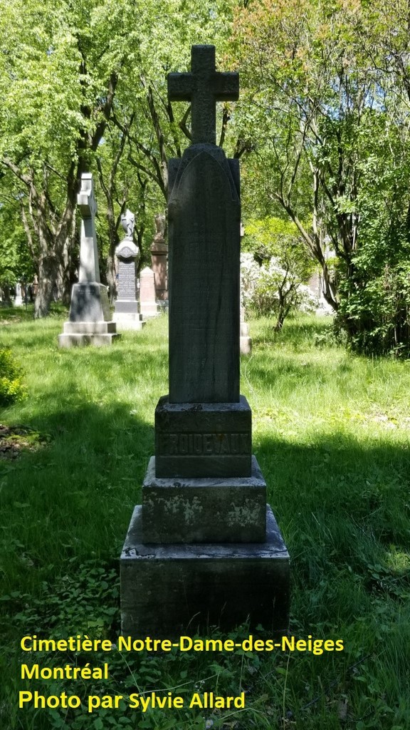
All his life, François Froidevaux took to heart the cause of orphans. He was thus a donor for the orphanage of Montfort. Our historian, Mr. Fernand Janson, recalls that he donated the first of the five bells of the chapel of the new Orphanage, of 1902; the one named Louis-Marie Grignon de Montfort, and weighing 360 pounds. freepages.rootsweb.com On his monument in the Notre-Dame-des-Neiges cemetery, it is inscribed: surnommé Le Père des Orphelins
To return to the railroad, the contract was signed before the notary Cléophas E. Leclerc, on September 2, 1896, in Montreal. It is kept at the Bibliothèque et Archives nationales du Québec (BanQ), archives of notaries. François Froidevaux must have been on good terms with the railroad company, since he was its director for a time, mentions the book from which his photo is taken.
"This construction will be done in all points in the manner required by Her Majesty Queen Victoria in the contract made between her and the said company...". "The ties of the road shall be at least six feet, ten inches in length, and as nearly as possible eight feet." The contract does not mention that this was to be the expanded, standardized track that would succeed the economic railway. This transformation, on the existing line, took place in the summer of 1897. The entire track, now joining Huberdeau, was completed in December 1897, as reported in an article by David Page:
"Mr. Froidevaux shall, at his own expense, and for the benefit of the said company, acquire by way of expropriation or otherwise, all the land required for the construction of the said railway and the necessary stations...". "...so that the whole thing will be completed and delivered on the first of August next (1897) ..." "...the said Sieur de Froidevaux will have the complete use of the equipment currently possessed by the said company for the execution of his work, with the charge of handing it over to the said company in the state in which he will have received it."
Mr. André Genest, resident of Montfort, former mayor of Wentworth-Nord and current prefect of the MRC des Pays-d'en-Haut, tells us that the land where the Montfort fire station is now built was named Froidevaux. In fact, a part of the current village is located on the former land of our contractor.
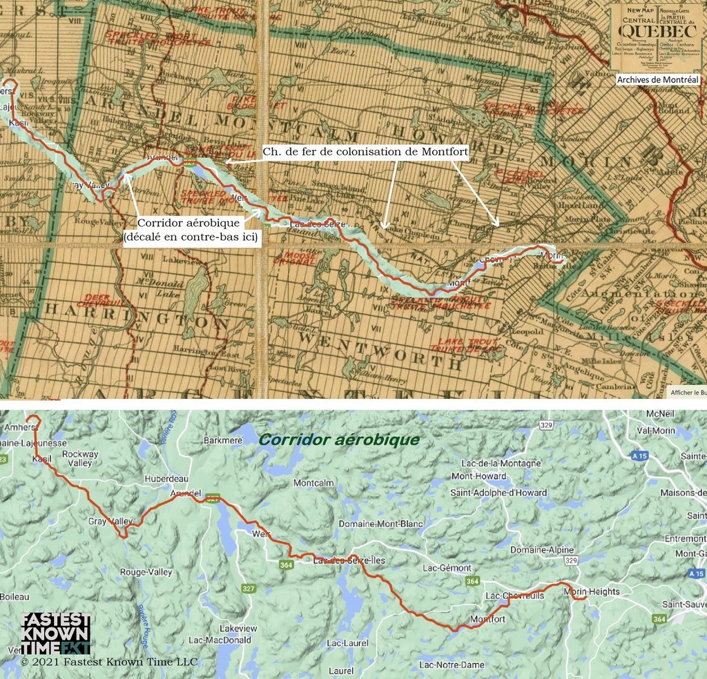
<Route of the Montfort Colonization Railway in Wentworth Township, added on a map of 1881
Aerobic Corridor Route: Between Lac-des-Seize-Îles and Huberdeau, this route roughly follows that of the Montfort colonization railroad as shown on anarchival map available from the City of Montreal. Fastest Known Time
Translated with www.DeepL.com/Translator (free version) & Linguee
By Carl Chapdelaine
Meeting with the mayor Saturday, oct 22
Meeting with the mayor Saturday 22,2022 at 1 o'clock at the Laurel library (on the side of Hotel de Ville)
Agenda,
1. closing of the aerobic corridor
2.The resolution from the mayors of Pays d,en Hauts and the consequences
3.The formal letter of notice to MRC,MTQ,MAMH
4.Public security (permission to occupy)
Colleen Horan, concillor, district 5
Blind property taxes
On Saturday, October 8, Mayor Desjardins met with the residents of Montfort and, more specifically, of Chemin-de-fer Street, at the Montfort Pavilion. She came to explain to them the respective place of each one and the decisions taken by the council in the annual maintenance of this street, including snow removal. She was undoubtedly also listening to the considerations raised by the said residents. The mayor also mentioned her administration's approach to the imposition of property taxes in light of the significant increase in assessment. This last point is the object of our attention.
The meeting, we were told, went well. The Mayor's thorough presentation of the situation, which essentially expanded on the content of her mot du 23 septembre dernier or the elements of the question period of the September 29 special meeting, was greatly appreciated, as evidenced by the applause directed towards her at the end of the meeting.
The property assessment, the mayor recalls, is done by an independent company hired by the MRC des Pays-d'en-Haut. She also indicated that the quotas that Wentworth-Nord pays to the MRC and the SQ represent about 50% of the municipal property tax and that we have no control over their setting. She added that the municipality is facing the same rising costs of services and goods as individuals. However, she assured residents that the tax rate will be lowered, so that the increase in property assessment, effective January 1, 2023, will not mean a proportional increase in their tax bill. The council could go, say, by 5%, close to the rate of inflation. (Journal de Montréal)
There were few questions following this presentation, except for the expression of dismay from a less fortunate homeowner who feared a tax increase she could not afford. And challenging the property assessment, from her experience, is no small matter. First of all, it would be necessary to understand the implausible discrepancy or imbalance in the assessments of Chemin-de-fer properties established by the firm Évimbec and available on the interactive map of GeoCentralis. These assessments do not seem to correspond to the market value of these properties.
The property tax, not being proportional to income, is often considered regressive; so the less you have, the more you spend on it. Ultimately, some may be forced to remortgage or dispose of their property. In Wentworth-Nord, according to the 2021 Census, 89% of households spent less than 30% of their income on housing, but for others, the situation may be quite different.
Is it not surprising that public authorities, in their blindness, can contribute to aggravate the problem of the housing crisis, accelerate gentrification and the desertion of certain neighbourhoods by the less fortunate, including the elderly, as in La Petite-Patrie, in Montreal, or Saint-Sauveur, in Quebec City, instead of applying the duty of social responsibility that they are responsible for?
Tax relief measures for lower-income households can be considered, and municipalities have some means at their disposal in this regard if we rely on the «Guide La prise de décision en urbanisme» of the MAMH. In addition, persons 65 years of age and older, whose family income did not exceed $54,700 in 2021, and who have owned their residence for at least 15 consecutive years, could obtain the ssubsidy for seniors related to an increase in municipal taxes which is intended to partially compensate for the increase in municipal taxes payable in respect of your residence following a significant increase in its value.
Particularly troubling is the case of the owners of Chemin-de-fer Street and those without road access. The former has been associated with a private street. But the equation seems flawed to us, as suggested by one of its residents at the September 29 meeting; the obligations are passed on to them, under the guise of fairness to other owners, but not the rights, it seems to us. (The issue of maintaining or municipalizing private roads is not new to Wentworth-Nord and has been the subject of several debates). And the government is raising their property assessments, at the same time as it is taking away their right to build on their vacant lots, if they have any; or prohibiting them from drawing any short-term rental income. Will some long-time residents who are elderly have to sell and leave, while simply asking the authorities for assistance in moving? Wasn't the former Wentworth-Nord administration, in the same spirit of fairness, justified in giving a maintenance tax rebate to these owners?
Translated with www.DeepL.com/Translator (free version) & Linguee
By Carl Chapdelaine
information meeting on Chemin de Fer’s maintenance
There will be an information meeting Saturday October 8 at 11 am at the Montfort Pavilion.
The Mayor will be talking about the Chemin de Fer’s maintenance for winter and summer.
The mayor will also discuss the taxation for 2023.
This meeting should be short and last perhaps 1 hour so that the citizens could enjoy their long weekend.
Thank you for your participation,
Colleen Horan
Wentworth-Nord Wants to repurchase Montfort Pavilion
Safety and transparency please!

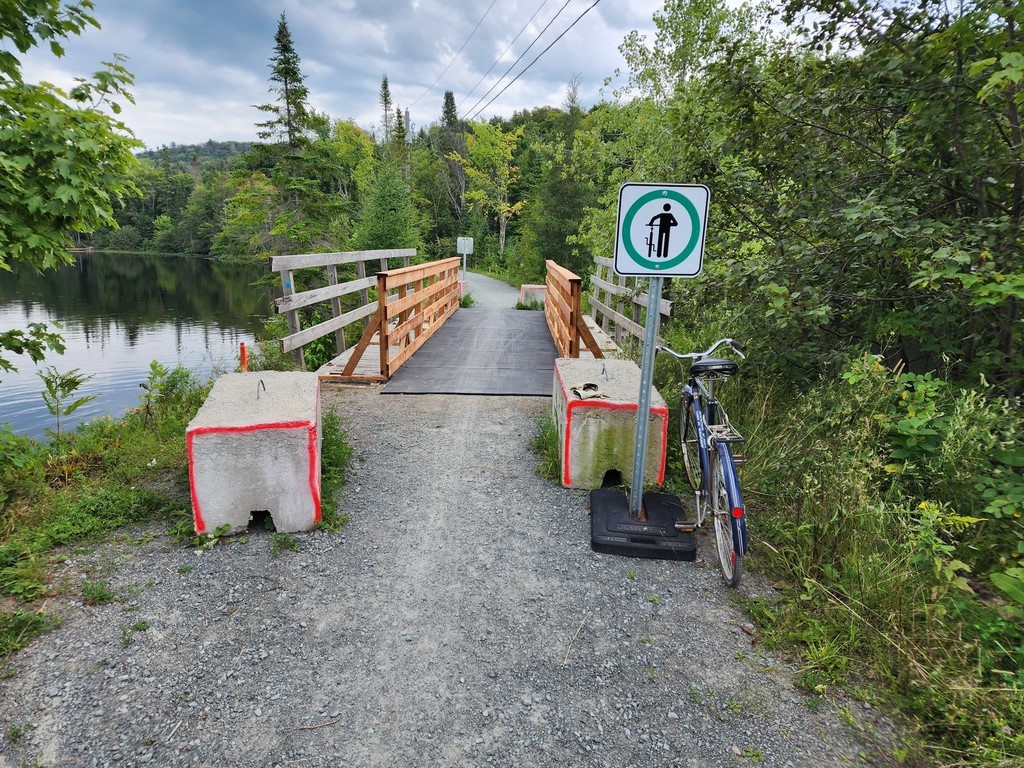
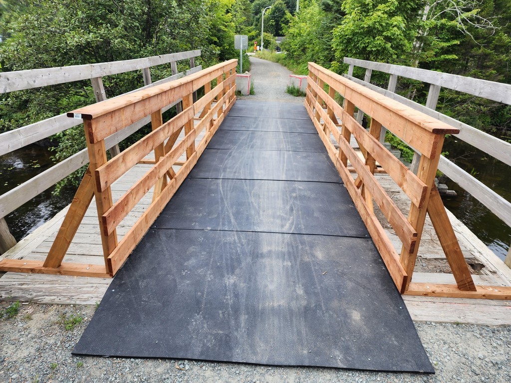
The closure of the Newaygo Bridge decreed last July, to follow up on the inspection report of December 2021, which recommended banning car traffic, raises many questions. This is what Simon Cordeau's article in the September 28 edition of the Accès newspaper suggests.
The Newaygo Bridge is a danger for the safety of its users, including cyclists who still use it, given the state of its railings, among other things; this is what the DWB Consultants report quoted by the journalist indicates. Pedestrians are not much more protected, in our opinion, and one should not jostle too much, for fear of tipping into the lake, a few meters below. But the MRC and the municipality of Wentworth-Nord, for the reasons indicated in the article, acted only belatedly for the first, or not at all for the second. This situation, even if it does not seem to be unique on the Aerobic Corridor, and the reaction of our local authorities, remain unacceptable.
The open conflict between the two municipal authorities concerning the responsibility for this bridge, as well as for the other capital assets or services they share in Montfort, must imperatively be resolved, even if it means mediation. The citizen has nothing to gain from this gladiatorial combat.
And what if they were also hiding the state of the situation concerning the "high capacity" dike, which holds back the two meters of water that exceed the natural level of Lake Saint-François-Xavier? The corrective measures recommended by the Services d’expertise hydrique of the Ministère de l'Environnement et de la Lutte contre les changements climatiques, in 2015, have "not yet begun according to the implementation schedule approved by the Minister". Could it be that the Coliseum is crumbling while our two gladiators battle it out? As luck would have it, in the data sheet* for these services, the municipality of Wentworth-Nord and the Municipalité Régionale de Comté des Pays-d'en-Haut are indicated as the owners or agents of this dike. "In what proportion," they will argue, as the cyclists ride and the water flows; or will each defend itself from being responsible?
With all due respect, by Carl Chapdelaine
*The date of the update of the file is not specified.
Translated with www.DeepL.com/Translator (free version)
Petition and moratorium on real estate development in Wentworth-Nord
The petition " relating to the integrated housing development projects underway and the projects under planning on the territory of the Montfort sector " was presented to the municipal council on September 19. With 262 signatures, including about 50 from Lake Saint-François-Xavier, this petition, which is still open, has certainly been a remarkable success. Its initiators congratulate themselves on having led the municipal council, during a special meeting, to put in place a moratorium on certain categories of real estate projects, along with an "interim control" bylaw "to initiate a process of modification of the municipal urban plan".
But an interim control by-law is not a solution in itself, and we are curious to know what the municipality will come up with after this moratorium. The task seems to us to be very ambitious. One wonders, among other things, what kind of municipal regulation would prevent the consequences of real estate development that the petitioners expect.
Clearly, Montfort and Lake St. Francois-Xavier, in particular, do not have the infrastructure (roads and bypass, parking lots, public beach and dock, etc.) to accommodate an increased influx of people, whether residents or visitors. The small beach, on the other hand, is reserved for Wentworth-Nord residents. Moreover, this influx of people can constitute a nuisance to the quality of life of the villagers who are in its path. However, there should be objective criteria to measure the variables involved. How many vehicles is it acceptable to see crossing the village, how many swimmers for a beach, paddleboarders or others in a lake? Yes, what is the carrying capacity of a small village, of a lake?
Even if the promoters of integrated or other projects in the Montfort sector do not mention it, their clientele, if they do not have direct access to a lake, will unerringly seek to use the public accesses of existing lakes in the vicinity, essentially for the moment and to our knowledge those of Lake Saint-François-Xavier. And it is not clear how any municipal regulation could prevent this.
Either we prohibit all non-riparian real estate development, since a threshold seems to be already being reached, or we adapt the infrastructures accordingly. And, since it seems to us that the sector cannot be prevented from developing, with both properties and rentals, even if they are short-term, it is difficult to imagine supporting the first option in its entirety; and then, the second option is necessary.
In this regard, the petitioners do not necessarily have the same long-term objective in mind. For some, it is a matter of seeking solutions that are appropriate to the situation, if any; while for others, it is a matter of permanently stopping any integrated project with a large number of properties, particularly those that rely on short-term rentals.
But isn't more public access on the lakes surrounding the developments feasible and, in the name of solidarity and equity, justifiable? Even if they may constitute a nuisance for the residents, swimmers, paddleboarders, kayakers, etc., do not harm the environment of a lake and cannot be deprived of controlled access. Therefore, no such reason will be given to justify their removal from the lake.
After adopting, in the spring of 2021, its environmental policy in the face of the urbanization that the municipality was facing, the municipal council of Sainte-Anne-des-Lacs tabled a first draft of its new policy on access to water during the meeting of August 8, we read in the newspaper Access. It was in response to the fact that nearly half of the property owners in its municipality, with its evocative name, did not have access to any of its 14 lakes, due to the lack of a public beach or dock.
The lakes are all, in a way, privatized, whether they are surrounded by prestigious "estates" with private streets and no access signs, or simply by a chain of properties that prevent access by others. The Council of this municipality is therefore proposing to create public access to its lakes that do not have it. Wentworth-Nord Council would also consider the need for such access. But this option, one would imagine, would have as many supporters among those without access as detractors among those without.
A formula that the undersigned has already put forward for Lake Saint-François-Xavier and that may exist elsewhere, is that of parking quotas and boats, probably with reservations. It has already been initiated with the vignette system. Indeed, parking has always been the first weapon to establish a kind of quota for the use of Lake St. Francois-Xavier. Obviously, more resources and an agreement with the MRC would have been needed to control it.
We imagined the establishment of a system similar to that of our national parks for this lake, half bordered by a regional park, and therefore where the MRC is, with the municipality, one of the two stakeholders. If, with the moratorium, it is a question of seeing in the longer term how the territory should be developed, this may be an opportunity to consider new formulas.
In the current situation of relations between the municipality and the MRC concerning Montfort, and in the face of the positions taken in several of the disputes that oppose them, it will be difficult to navigate towards a more appropriate land use plan. It should be noted that the municipality was quick to limit the government's "interim control" formula to the municipal level, as was Mont-Tremblant. This is already dismissing an essential player in the search for the best solutions for Lake St. Francois-Xavier, including the one we imagined. However, no global measure here, as for a good part of Montfort's problems, will be able to be put forward without a collaboration between the two levels of municipal power, and even the support of the MRC.
Furthermore, we would have the advantage of seeing what Morin-Heights, Sainte-Anne-des-Lacs and other towns in the Laurentians that have faced the problem highlighted by the petition and the moratorium before us and that must put forward solutions. But we need to be shown that our small municipality will have the means and the power to modify its urban plan in the desired direction (which one?) and that the moratorium will have served a purpose.
It will also be necessary, as foreseen in the consultation process announced by the Wentworth-Nord council, to hear the point of view of the promoters, to take the opinion of the current lodgers, and to guarantee them the place they deserve in these consultations. Moreover, in our society of law, we cannot presume bad faith on the part of either party. It is therefore necessary to rely on objective information and well-prepared and well-reviewed consultations.
Translated with www.DeepL.com/Translator (free version) & Linguee
By Carl Chapdelaine
Petition for Moratorium on Development in Montfort sector
The Executive of the association would have decided not to forward the petition to its members; but he has since changed his mind!
Our comments
The undersigned particularly shares the opinions expressed in some of the whereas of the petition, such as
- That the " development projects are in addition to many projects completed or in the process of being completed, in particular: the various phases of the St-Victor estates (Lac St-Victor, Lac St-Cyr, la Héronnière, les Sommets, Montagne Bock), Lac Pelletier, cottages for rent on the road to Lake Wheeler, Lac Thurson, etc.")
- That " the state of public infrastructure in the Montfort sector has deteriorated sharply due to the increase in traffic caused by new developments causing problems related to increased road traffic on a single artery".
- (To be added as whereas) that obviously: the village, with its too little infrastructure, and Lake Saint-François-Xavier, with its public small beach, boat ramp and dock, unique in the area apparently, are not currently able to support the traffic and other nuisances that these projects will create.
- That these " these projects have cumulative environmental impacts, particularly in terms of groundwater resources, noise and visual impacts and the protection of sensitive environments.”
- That “the municipality has not demonstrated that the economic benefits of these projects justify the externalities that these projects will generate."
- That “the last urban plan of the municipality was produced in 2017 (and) does not take into account the current pressure of developments on the municipality."
However, demanding a moratorium on development in the Montfort sector while waiting for the update of the urban plan, seems to us to have to create a dead end. Indeed, although it is essential, such an update does not seem possible for several years, unless we can devote the necessary resources of the municipal administration.
Furthermore, we would also need to know the impact of such a moratorium on the socio-economic development of the sector and of the entire municipality, as well as the financial and other consequences for promoters already engaged in projects, or even those who would consider choosing the Montfort sector to develop new projects.
Furthermore, the consequences of forcing the hand of a duly elected municipal council with its own knowledge and vision of the issues at stake here, remain uncertain.
And speaking of consultation, such action on the wording of the petition might have been necessary.
Without prejudice, by Carl Chapdelaine
--------------------------------------------------------------
The petition <-- link
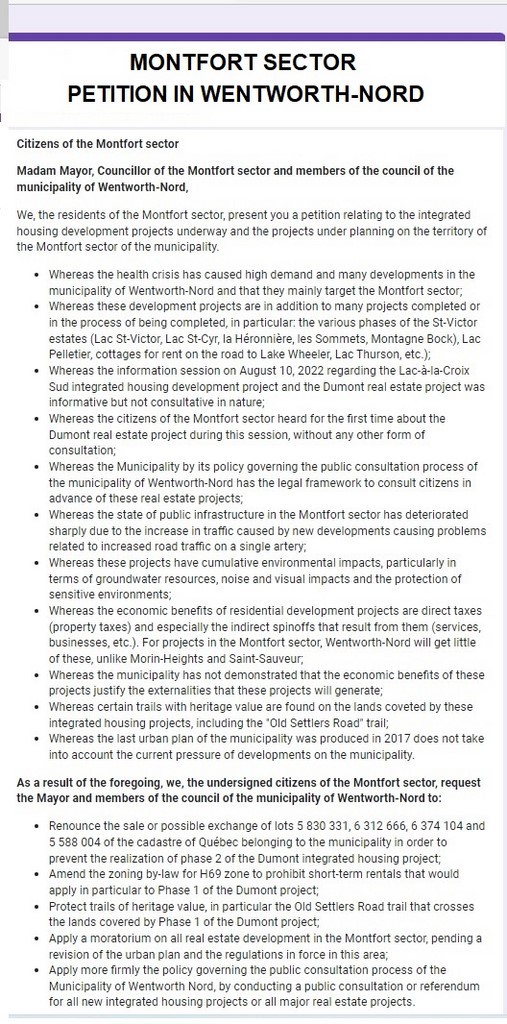
Citizens of the Montfort sector
Madam Mayor, Councillor of the Montfort sector and members of the council of the municipality of Wentworth-Nord,
We, the residents of the Montfort sector, present you a petition relating to the integrated housing development projects underway and the projects under planning on the territory of the Montfort sector of the municipality.
Whereas the health crisis has caused high demand and many developments in the municipality of Wentworth-Nord and that they mainly target the Montfort sector;
Whereas these development projects are in addition to many projects completed or in the process of being completed, in particular: the various phases of the St-Victor estates (Lac St-Victor, Lac St-Cyr, la Héronnière, les Sommets, Montagne Bock), Lac Pelletier, cottages for rent on the road to Lake Wheeler, Lac Thurson, etc.);
Whereas the information session on August 10, 2022 regarding the Lac-à-la-Croix Sud integrated housing development project and the Dumont real estate project was informative but not consultative in nature;
Whereas the citizens of the Montfort sector heard for the first time about the Dumont real estate project during this session, without any other form of consultation;
Whereas the Municipality by its policy governing the public consultation process of the municipality of Wentworth-Nord has the legal framework to consult citizens in advance of these real estate projects;
Whereas the state of public infrastructure in the Montfort sector has deteriorated sharply due to the increase in traffic caused by new developments causing problems related to increased road traffic on a single artery;
Whereas these projects have cumulative environmental impacts, particularly in terms of groundwater resources, noise and visual impacts and the protection of sensitive environments;
Whereas the economic benefits of residential development projects are direct taxes (property taxes) and especially the indirect spinoffs that result from them (services, businesses, etc.). For projects in the Montfort sector, Wentworth-Nord will get little of these, unlike Morin-Heights and Saint-Sauveur;
Whereas the municipality has not demonstrated that the economic benefits of these projects justify the externalities that these projects will generate;
Whereas certain trails with heritage value are found on the lands coveted by these integrated housing projects, including the "Old Settlers Road" trail;
Whereas the last urban plan of the municipality was produced in 2017 does not take into account the current pressure of developments on the municipality.
As a result of the foregoing, we, the undersigned citizens of the Montfort sector, request the Mayor and members of the council of the municipality of Wentworth-Nord to:
Renounce the sale or possible exchange of lots 5 830 331, 6 312 666, 6 374 104 and 5 588 004 of the cadastre of Québec belonging to the municipality in order to prevent the realization of phase 2 of the Dumont integrated housing project;
Amend the zoning by-law for H69 zone to prohibit short-term rentals that would apply in particular to Phase 1 of the Dumont project;
Protect trails of heritage value, in particular the Old Settlers Road trail that crosses the lands covered by Phase 1 of the Dumont project;
Apply a moratorium on all real estate development in the Montfort sector, pending a revision of the urban plan and the regulations in force in this area;
Apply more firmly the policy governing the public consultation process of the Municipality of Wentworth Nord, by conducting a public consultation or referendum for all new integrated housing projects or all major real estate projects.
By Carl Chapdelaine
Translated with www.DeepL.com/Translator (free version) & Linguee
Presentation of Domaine du Lac Pelletier project
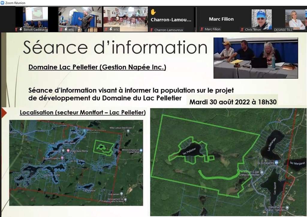
By Gestion Napée Inc.
Presentation by the promoters, Mr. Simon Matte and Mr. Fernando Balthazar, organized by the municipality of Wentworth-Nord and its Urban Planning and Environment Department, under the direction of Mr. Benoit Cadieux. Held at the Laurel Community Center on August 30, 2022. The Zoom application will indicate 26 participants. Half a dozen people attend from the audience.
The mayor, Mrs. Desjardins gives the usual recommendations: questions and not discussions.
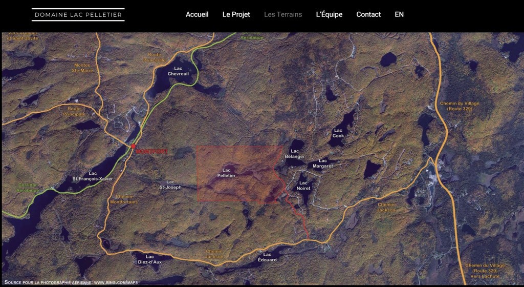
Note: Lake Pelletier is located 2 km east of the Montfort Basin of Lake Saint-François-Xavier. The Gestion Napée Inc. project is accessible by Lac-Noiret road, connected to Jackson road and leading to highway 329.
Presentation
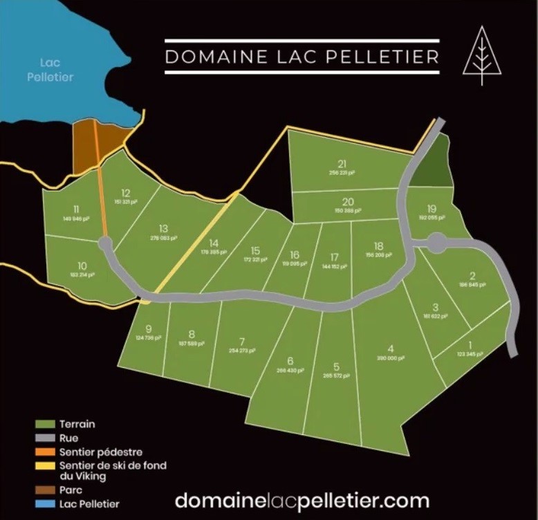
With the help of projected maps and plans of the future estate, Mr. Matte indicates that the delimitation of 19 lots, with an average surface area of 193,000 (?) sq. ft. (17,930 sq. m), on either side of a 950-meter road, will ensure a low density of habitat next to Lake Pelletier. This exceeds municipal requirements. In fact, only one common lot in this integrated project will be waterfront. It will allow access to the lake for these 19 property owners, with the possibility of launching kayaks and other light boats. The lake would be closed to motorized navigation.
[This is a far cry from the previously presented project, with more than 120 units in the same space, which had generated strong opposition. In June 2018, the city council had increased the minimum area of a lot in the basin of Lake Pelletier from 7,500 m2 to 10,000 m2; (Without taking into account that this was an integrated project, for which the requirements were nevertheless less?)]
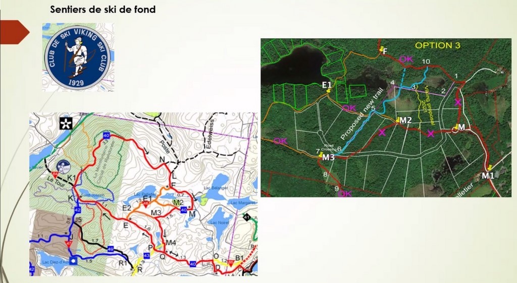
The promoter points out that it is not (as can be seen on the plan) a road that would go along or around the lake. He explains that they have commissioned all the necessary studies, environmental, etc. The trails are protected. Councillor Johnston will confirm that all regulations are respected.
Question period
Mr. Marc Filion, on Zoom, will ask a few questions, including one on the presence of wetlands on the land of this future domain and a question on the fact that Gestion Napée did not make sure that their road could eventually join the other properties on the lake, we understand. The mayor answered that the regulations govern this problem of wetlands; while Mr. Matte explained that they did not have to plan to build a road that could serve other properties than their own.
In the same vein, property owners on the lake will ask if they will still be able to access their land (by passing through the Gestion Napée property?) The promoter will answer that they do not have the right to enclave properties anyway. Has Ms. Desjardins assure these owners of a follow-up on this matter?
A participant wanted to know if there would be short-term rentals. The developer will assure her that there will not, and Mr. Cadieux will clarify that this type of accommodation is not permitted in the Lac Pelletier area.
A gentleman asked if the common lake access area of the project will be accessible to other owners. Answer: No.
The undersigned asks if, in the 7% required for parks in any subdivision, the municipality has reserved a portion of the shoreline attached to this project. The promoter will answer that the 7% was paid at the time of the first request and that the municipality did not reserve any land on the shoreline; this was confirmed by Mr. Cadieux. The mayor will specify that many lakes in Wentworth-Nord are in the same situation; but that this possibility will be studied for future projects when it will be possible. Councillor Johnston will specify that the Viking ski trail passes by the lake.
Mr. Mathieu-Jules Filion, associated with Constructions Invesco, a company from the Laurentians and who owns land at Lac Pelletier, will take up Marc Filion's question on the "hemmed-in" imposed by the Domaine du Lac Pelletier project on the other owners and the obligation that he would attribute to them to connect the other properties of the lake by their road, we understand. We know that the knives are flying low at Lac Pelletier between these two companies...
Subject to correction, by Carl Chapdelaine
Translated with www.DeepL.com/Translator (free version) & Linguee
Montfort Railway CN Stations from St-Eustache to Huberdeau
Photos collected by Steven Larose, in "Il était une fois les Laurentides", on Facebook.
Two projects for Lake Saint-François-Xavier (Report)
Presentation by the promoters organized by the municipality of Wentworth-Nord and its Urbanism and Environment department, under the direction of Mr. Benoit Cadieux. Held in Laurel on August 10, 2022.
The Zoom application indicates 38 participants at the beginning of the session; this number will later approach fifty. A dozen people attended the meeting in the Community Center.
The mayor, Ms. Desjardins, gave the usual recommendations: Questions, not discussions. Be concise. Then Mr. Cadieux invited the promoters to present their projects.
Lac-à-la-Croix-Sud Project
Developers: George Batchoun (contractor) and Milko Dimitrov (architect).
This integrated project, in the Lac St-Victor Estates, covers a land of 260,000 m2, made up of lots grouped together to the south-east of Lac à la Croix. It goes from the private road Berges-du-Sud, at its junction with Notre-Dame-Nord Road, in its first phase, and will practically reach the head of Lake Saint-François-Xavier in a second phase. To the south, it runs along Notre-Dame-Nord Road, from which it is separated by a thin strip of land, and to the north, it is bordered by Lake à la Croix and the marsh that separates it from Lake Saint-François-Xavier. The promoters say that they did not connect directly to the Notre-Dame-Nord public road so as not to have to cut down the trees that border it.
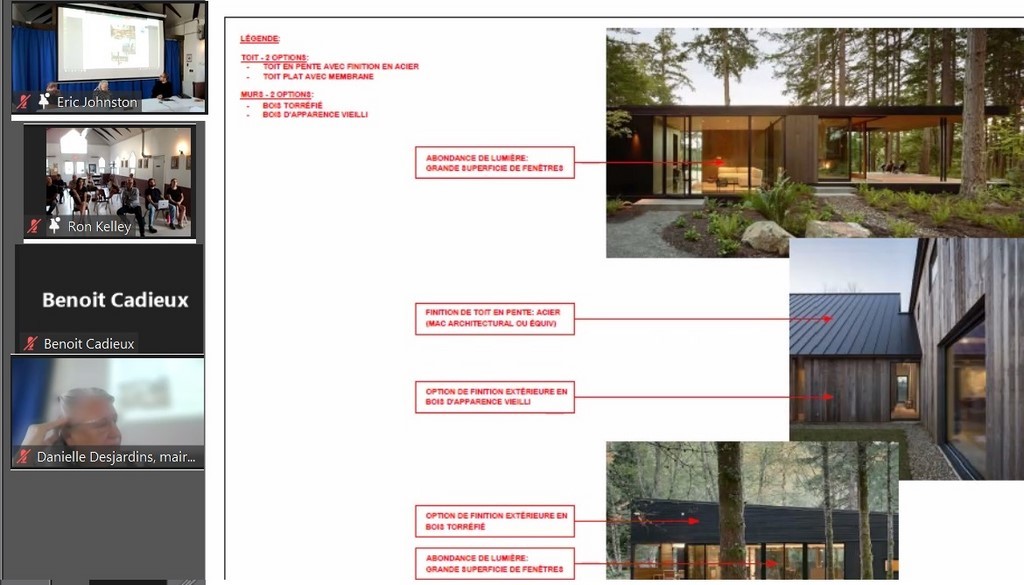
It includes only half a dozen properties, which means they are large (and already sold?). The luxurious homes will be of a modern and uniform style. These specifications would imply, among other things, a lower environmental impact.
The majority of these properties are waterfront, and a common dock will also be built. But this small, shallow lake is non-navigable and only kayaks, paddleboards and other non-motorized watercraft will be allowed in the water, the developer says.
A large common recreational area will include trails connected to existing networks.
A common area, at the entrance, will serve as a depository for garbage, etc.
Another common area will be dedicated to sports and other activities (tennis court, etc.).
The entrance driveway will be on Berges-du-Nord Road, at a derogatory distance from its intersection with Notre-Dame-Nord Road.
Question period on the first project
- On the question of the possibility of access to Lake Saint-François-Xavier for these future residents of Lac à la Croix, Councillor Eric Johnston, who is involved in these files, recalled that the by-law adopted by the municipal council does not allow multiple access to Lake Saint-François-Xavier from this side (one must be a shoreline owner of the latter lake to have access to it). Mrs. Desjardins also recalled that several owners have already included clauses (in their sales contracts?) that prohibit (any right of passage?).
- In the wake of this access issue, did we hear the mayor indicate that they would look, with the Director General, if there was a way to help the owners without road access in the southwestern part of the Newaygo basin? It is known that the private road from Lac à la Croix leads to the lands of this basin and that some see it as an easy access to part of these properties.
- After several questions, not to mention the comments made on the Zoom application site, but which we were unable to note, Mr. David Clark wanted to remind us that Lac à la Croix is a nerve centre of the Lake Saint-François-Xavier watershed, and that we needed much more analysis, consultation and guarantees on the possible impact of this project on the latter lake. Above all, it was necessary to avoid new environmental disasters such as we had seen before.
The promoter affirmed that an environmental study had accompanied the development of the project. He claimed that the municipality had been very strict and that all its directives had been respected.
- .... .... ....
Real estate project of the Mont
This integrated project, less advanced than that of Lac à la Croix, could be realized, in its two phases, over about fifteen years, we understand.
It foresees several dozen properties staggered on either side of a central alley. The lots here are much smaller than those in the previous project. They would be more like rental homes, we were told.
Located southwest of Thurston Lake, it will take advantage of the presence of Thurson Lake Road. This road will become a major real estate development axis between Notre-Dame, Saint-Victor and Saint-François-Xavier lakes.
These properties would have no access to any of the surrounding lakes.
Note: Here, our internet connection failed and we have no further data on this second presentation. A good Samaritan might want to report on it...
Our comments
The initiative of the municipal council to present these private projects to the population has aroused a strong participation and thus demonstrated the interest of the latter in the face of the development underway in the Montfort sector.
These two integrated projects imply a consequent development around Lake Saint-François-Xavier and the village. The presentation of the projects by the sympathetic promoters, the demonstration of their concern for a sustainable development, with a minimal impact on the current environment and which respect all the norms in force, their answers to the questions of the residents would lead one to think that everything will be for the best here.
The question we forgot to ask is the one we had already presented during the consultations on the first project at Lac à la Croix: "Will there be a global study on the environmental impact of such projects on Lake Saint-François-Xavier? The answer was that the realization of the Lac à la Croix project, after its adoption by the municipal council, would indeed be subject to the respect of environmental standards before its realization. But what were those standards or criteria for compliance analysis, and what were the conclusions?
Mr. David Clark happily raised the issue of assessing the impact of these projects to be carried out in the headwater portion of the watershed, and thus at the most sensitive point of its ecosystem. He asked that a detailed study be undertaken and opened to the knowledge of the residents. This paving stone in the pond, which he justified by the environmental disasters suffered at the lake in the recent past, may have seemed out of context and beyond the scope of the municipality's analysis of such projects. And yet, this is, in our opinion, a bit of a leap into the unknown.
Developers are probably not asked to assess the overall impact of their projects on a territory that extends far beyond their property. How can one imagine, indeed, that the deforestation, among others and even limited to the minimum, around the so fragile Lac à la Croix, will not have a negative impact on the lake itself. The runoff will increase and will bring its share of inputs in the lake. At the shoreline property level, the development of water access will involve breakthroughs in the forest cover that protects the lake from warming. For example, won't this increase aquatic vegetation in such a shallow stream? Will we not find ourselves in the more distant future in a marsh rather than a lake, as is the case at the head of Lake Saint-François-Xavier itself?
And has the impact of the increase in the number of residents on traffic, mainly caused by the second project, been measured? If the mayor points out the current nuisance of truck traffic on Notre-Dame-Nord Road caused by the current development, what about upstream? Where do these trucks come from? They have no choice but to come from Montfort Road, to go through the village and end up on Montfortains Road, or to come from Jackson Road. The nuisance of this traffic is already evident in the village and the permanent impact of the two projects underway will not improve things.
Surely in search of a beach and a lake to navigate in the summer months, the more than 100 vacationers in the Mont's real estate project will have no choice but to turn to the already overflowing offer of the tiny public beach and dock on Lake St. Francis Xavier?
Where are the answers? Where is the passage in the 2017 urban plan that addresses this? What does City Council say about it? Doesn't it seem obvious that we are being forced to move forward, to allow the necessary development, without fully knowing the consequences or having planned for the future? One thing is clear: the village is almost certainly not in a position to support it.
We believe that the involvement and assistance of the MRC des Pays-d'en-Haut and the higher authorities are essential for a longer term evaluation of the impact of development in the Montfort sector. But we are aware that this will not come or that it is already too late.
With all reservations, by Carl Chapdelaine
The Montfort/Newaygo Regatta
The 55TH Edition
The 55th edition of the Montfort/Newaygo regatta was held on Saturday, July 30, 2022. The start time was scheduled for 1:30 pm. The first event started at 2:00 PM and the last event took place at 5:30 PM. Although the skies were cloudy to start, and a brisk wind made the temperature a little cool, the weather got onboard by mid afternoon with the skies clearing and the wind although still gusty quite manageable. The Regatta has been a Clark Family project for 57 years and is supported by the Lake St Francois Xavier Lake Association. The Regatta has maintained its simple approach with the goals of bringing the community together in a participatory and fun way. The events provide an opportunity for both guys and girls from toddlers to Great Grandfathers to compete. This year’s Regatta was a very special one. The pandemic did not permit holding it in 2020/21 and we were worried that it might have drifted from the community’s radar and attendance would be low. We got a very big and happy surprise. Although attendance at the start was a little slow, we had over 60 participants, either spectators or competitors in attendance at one point. All were residents of District 5. This was also a change from previous years where users of the Aerobic Corridor often stopped to participate and challenge us locals. In the lead up to the Regatta I got many phone calls from residents expressing their hope that we would hold it this year. Several families shared the fact that they scheduled their vacations at the lake specifically to coincide with the Regatta. This kind of feedback and interest is very rewarding and has played a big role in the Regatta’s long history.
The ribbon and award presentations were held at 8PM on Saturday Evening when everyone gathers around a big bonfire to socialize and cheer the competitors. Ribbons are awarded for first, second and third place in each event. Once that is completed the tension heightens as the Medals for High Aggregates in each Age group, one for the Guys and one for the Girls in that group, are awarded. Then, everyone holds their breath in anticipation of which competitor will win the Bob Clark Trophy which is awarded to the athlete, 15 years old or under that has accumulated the most points overall. The trophy honors Bob Clark who has been the kingpin in keeping the Regatta going for 57 years. I will not list all those who won ribbons, but I will list the winners of the High Aggregate Medals and the winner of the Bob Clark Trophy They are as follows:
High Aggregate Medal Winners:
Girls 10 and Under: Rachel Rivest
Boys 10 and Under: William Strath
Girls 12 and Under: Olivia Rivest
Boys 12 and Under: Cameron Rennie
Girls 15 and Under: Katlin Rivest
Boys 15 and Under: Cameron Rennie
Ladies Open Class: Emilie Clark
Mens Open Class: David Lloyd
Now for the Drum Roll:
The bob Clark Trophy (15 Years and Under)
Katlin Rivest
The current version of the Montfort/Newaygo Regattas is now in its 57 Year. However, the history of the Montfort/Newaygo Regattas is much longer. The first one was held in 1918 and although there have been a few years with no regatta the tradition of celebrating Montfort/Newaygo has been honored for over 100 years. That is quite the achievement in todays society of constant change.
David Clark
MRC Council meeting of July 12, 2022 (report)

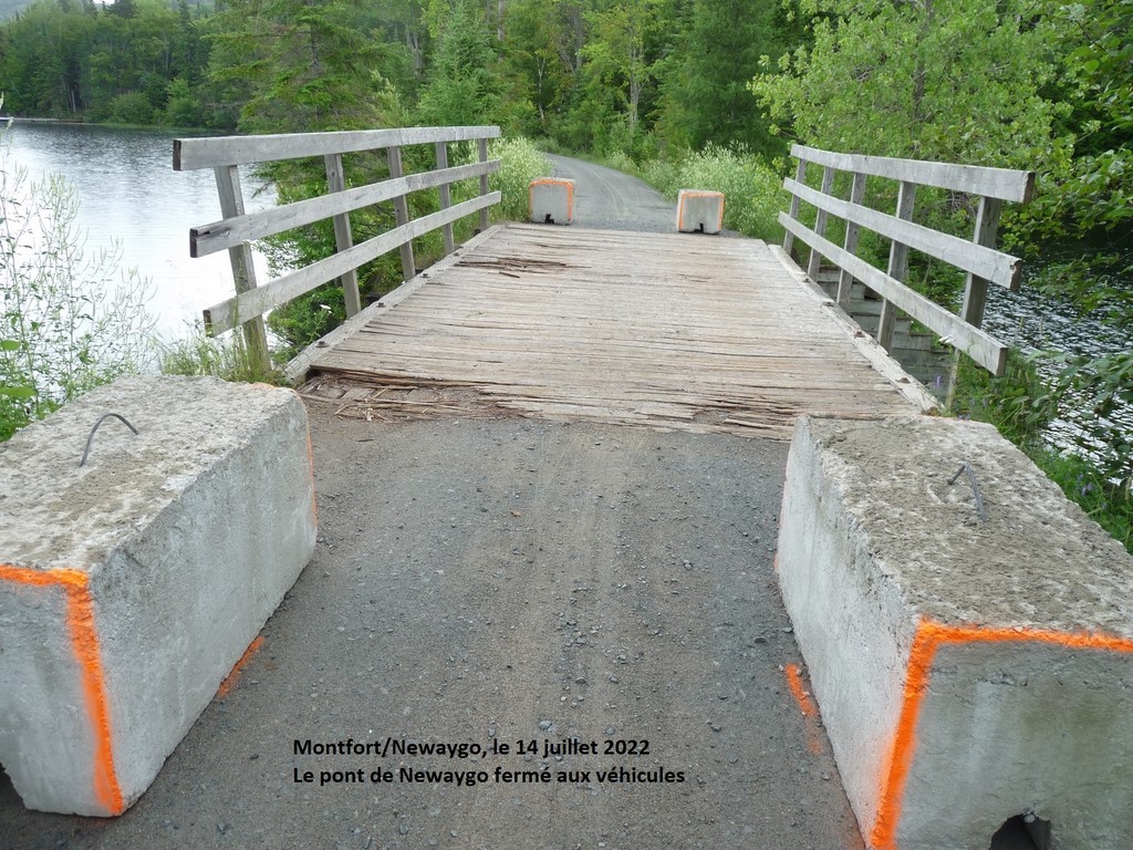
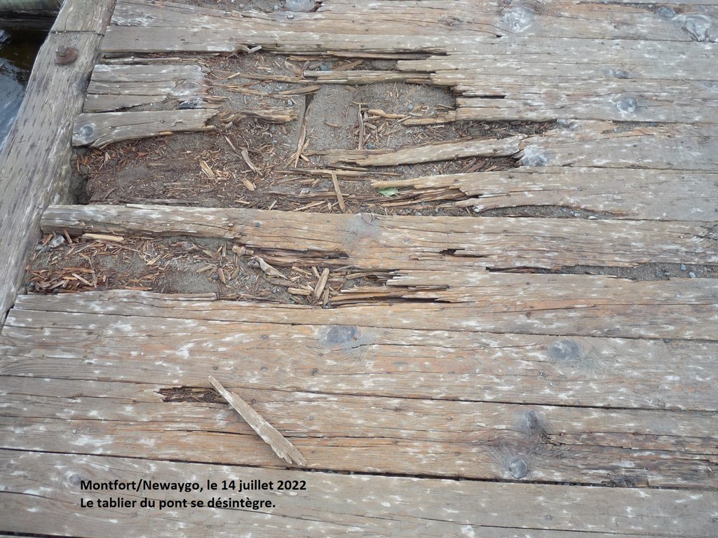
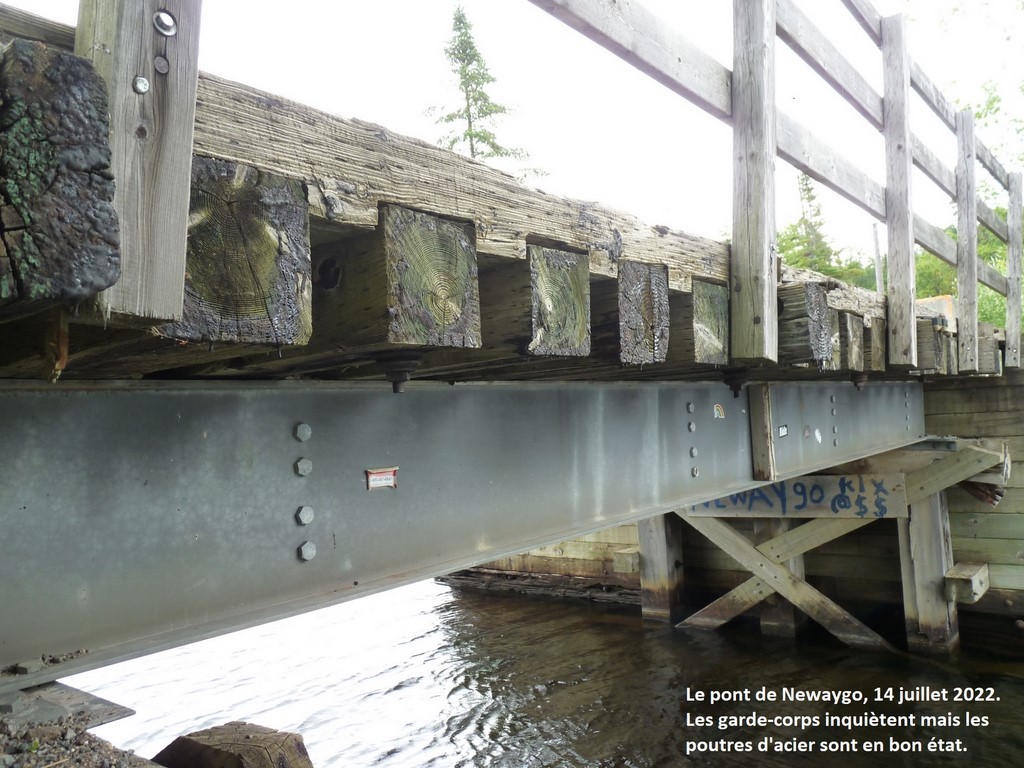

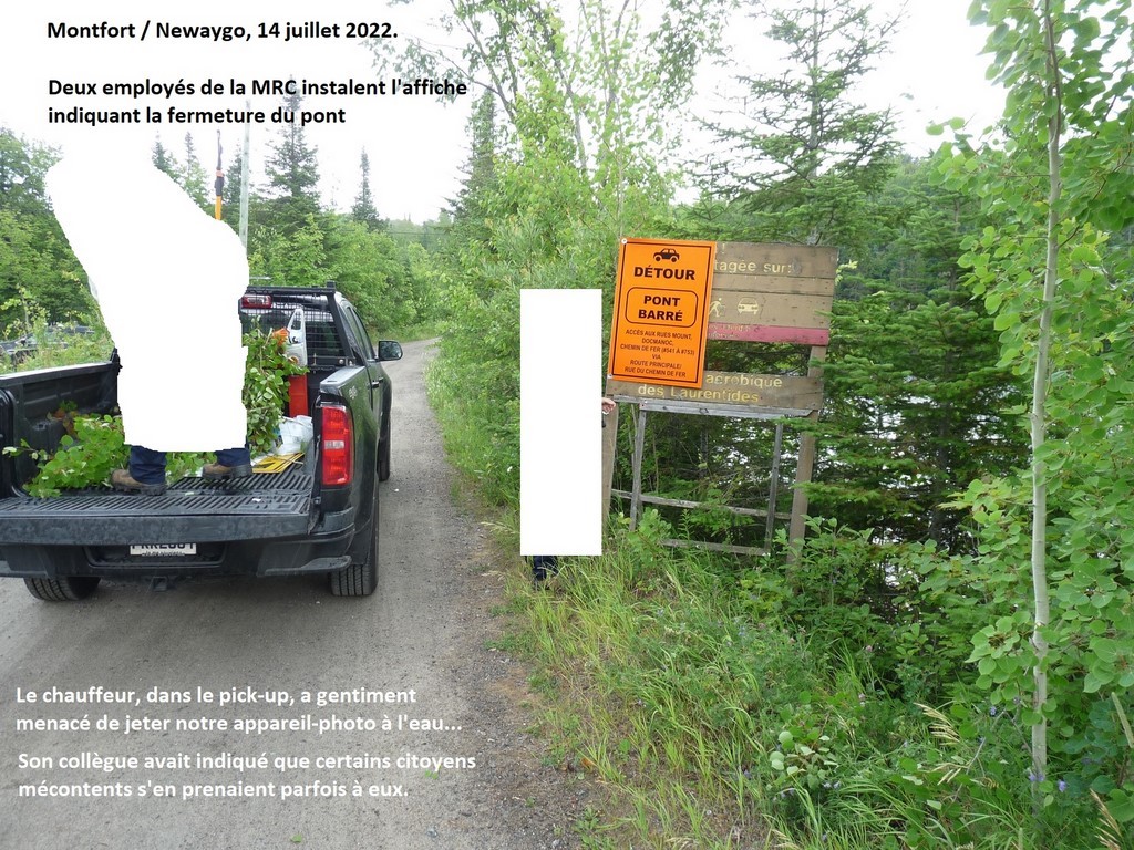
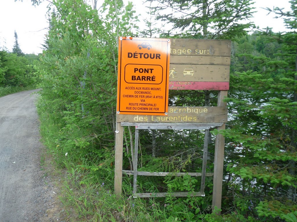
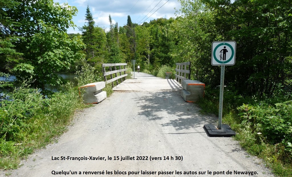

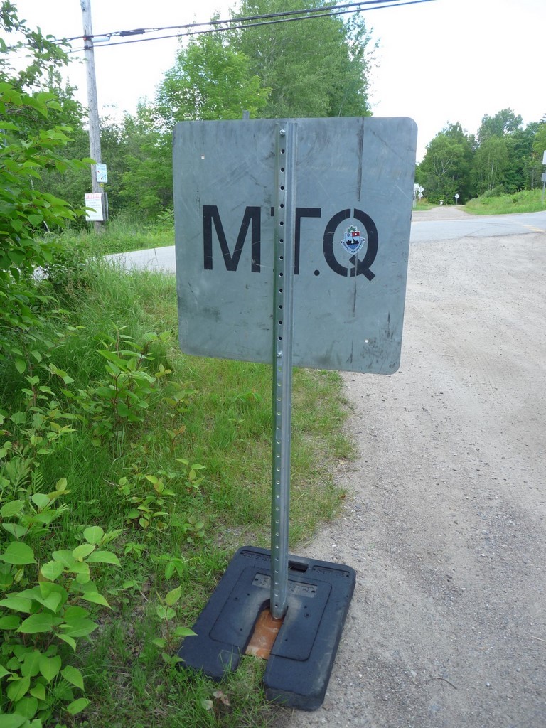


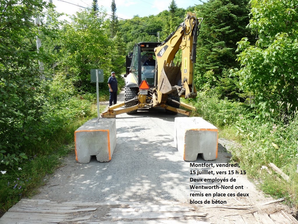
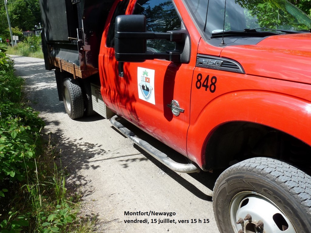
Mr. André Genest, Prefect, chaired the meeting which was held in Morin-Heights.
Item 9: The Newaygo bridge. It is our understanding that this is a proposal to immediately close the bridge to vehicular traffic as a result of the DWB engineering inspection report of December 7, 2021. The report concluded that the deteriorated condition of the bridge deck posed a safety hazard to users. The mayors instantly adopted the proposal; the objection of the mayor of Wentworth-Nord would not have changed anything.
Question period
- According to District 5 Councillor Colleen Horan during this question period: - The bridge is owned by the MTQ and the department would be fully responsible for its maintenance, as was the case for its repair in 2014. - The MRC fulfills the contract performance obligation for this maintenance, as it does for the entire Aerobic Corridor, including the bridge.
- Someone asked how the access to rue Principale will be done for the 13 or 14 properties concerned on Docmanov, Mount and Chemin-de-Fer streets? It will be temporary from the portion of Chemin-de-Fer Street starting at rue Principale. Traffic lights could be installed. We heard from the Prefect that the original status of most of these properties was water access.
- A resident asked why the Newaygo Bridge can no longer accommodate vehicles? Prefect's response: This is the conclusion of the engineers' report, which has also been shared with the Municipality of Wentworth-Nord.
- Another question: What will happen to this bridge or its replacement? Prefect Genest answered that a temporary deck over the existing one might be set up. Further study is required to determine what can be done. We should know more in August or September.
- Since there will no longer be garbage collection, what will we do with it? We will have to put it in the semi-buried containers in Montfort or walk to the ones in Newaygo. Residents in the room objected vigorously to this decision and did not see why garbage trucks could not, still twice a week, use the Corridor, as emergency or delivery vehicles (?) are still allowed to do. Answer: No garbage trucks will be sent on the Corridor, so as not to increase traffic. On the other hand, it is obvious that some people will not respect the bans. (The new mayor of Piedmont, Mr. Nadon, rebuffed the arguments of the residents present, but was called to order).
- Ms. Desjardins affirmed that the MRC was attempting to charge her municipality with a share of the maintenance obligation for a bridge that does not belong to it. The contract was only between the MTQ and the MRC. It is known that Wentworth-North does not intend to pay any money for the eventual rehabilitation of this bridge, whereas the MRC is asking for a 40/60 split.
- Councillor C. Horan stated that the MRC was not being fair to the residents along the Corridor; and she wondered if the MRC was somehow forcing the municipality's hand by proposing the construction of a new road to connect the Mount-Docmanov-Corridor sector to Thurson Lake Road. [
- Mr. Garvin Gibb, who asked some of the previous questions from the floor regrets that too few lake residents attended this last-minute session. He will remind us that the project to bring this sector to Thurson Lake Road, via the new Mount Street (des Érables) had been put forward by Mr. Genest, when he was mayor of Wentworth-Nord. However, the overrun of more than $300,000 in budgeted costs for this road made the operation unfeasible]. Mr. Genest will have the opportunity to state that the MRC is not against Wentworth-Nord, as some seem to believe; that the two levels of municipal government work together.
- Did we also hear Mrs. Desjardins plead that the distribution of costs between the MRC and the municipality for this type of maintenance on the Corridor or at the Montfort Pavilion, does not reflect, among other things, the position of the latter in the population figure of the MRC, which is only 3%.
With all due respect and borrowing some comments from Ms. Horan and Mr. Garvin Gibb, by Carl Chapdelaine
Translated with www.DeepL.com/Translator (free version) & Linguee
Entente MRC-Wentworth-Nord sur le pavillon Montfort

Welcome at the Montfort Pavilion
On this Wednesday, May 18th, you can have your boat washed by the municipality's attendant. If there is someone at the reception desk of the pavilion, it is the washing attendant who uses the computer. On Saturday, the 14th, about 20 washes were done. With a rainy Sunday, it was completely quiet.
No overflow to report on the parking side during this short weekend, it seems. But, the next one will be the Queen's for the Canadians, the Patriotes for the Quebecers, Dollard des Ormeaux for the nostalgic, (we forgot the First Nations and other ethnic groups.); the MRC should post an attendant there. Many cottagers will open their summer cottages, give water to the hummingbirds and food to the little black flies, all hungry.
The washing specialist will be assisted by a second one for the occasion. For information, the mayor told us, you will have to contact the municipality or the MRC, depending on the subject; but if you don't know who to contact... To do this, the Internet should work at the pavilion, if you have your equipment. To get the code, you'll need a bit of insight. (Remember that the employees at the offices of both municipal entities must enjoy the weekends as well). You should be able to find the washroom with no problem.
Once in the water, follow the rules and regulations; buoys should be reinstalled everywhere and the Sûreté du Québec doesn't go anywhere for nothing.
Excuse them!
Translated with www.DeepL.com/Translator (free version)
The future of the Montfort Pavilion (question for the mayors' council)

We are told that the MRC will set up a reception brigade and will manage the parking lots.
The washing of the boats will be assured by the municipality; but what about the control of the launching of the boats?
How will the probable influx of visitors be managed during the next summer long weekends, for which the memory of the last few summers still makes us fear the worst?
What is the future of this pavilion; of this decaying building? Who will manage and decide on all this? What about the future of the Montfort Art Gallery? And who will pay?
Carl Chapdelaine, vacationer at Lake Saint-François-Xavier
Response from the Prefect and the Mayor of W-N
Mr. A. Genest:
o All these points are part of the ongoing negotiations with the municipality.
o Mrs Chantal Ladouceur is the contact person at the MRC on this file. (Mr. André Genest also mentioned SOPAIR).
o Mr. Chartier should continue to open the door.
o I cannot answer all your questions now.
Mrs. D. Desjardins:
(The voice transmission is cavernous; but we understand that the mayor is essentially repeating the points she had listed in a recent press release and presented at the April 20 council meeting of the municipality.)
Translated with www.DeepL.com/Translator (free version)
Montfort consultations, summary
Note: The problems mentioned and the proposed solutions may apply to several of the three consultation topics.
Corridor and lake
Problems mentioned:
1. Visitors with little awareness
a. On the lake: noise, dispersion of skateboarders and kayakers;
b. on the corridor: speed.
2. Insufficient control
3. Important cost for the Municipality; with no economic spin-off.
4. Decisions are made by the MRC.
5. The MRC creates the problems, but does not know or ignore them, and does not offer a solution. The MRC is absent from consultations, from discussions with residents.
6. Insufficient management.
7. Tourism promotion is the problem.
8. Crowds of visitors; saturation point.
9. Danger to the lake environment.
10. Danger to safety, both on the lake and on the Corridor.
11. Poorly maintained roadway
Proposed Solutions:
1. Constables and staff: $$.
2. Reservation system with quotas.
3. Limit access to boats, bathers, cyclists: yes/no.
4. Limit boats, paddleboards, etc. to on-site rentals.
5. Separate lanes on the Corridor, on the lake. Yes/No.
6. Re-activate automated gate.
7. More signs to limit speed on the Corridor.
8. Speed bump: yes/no.
9. Charge for washing, parking, lake access; make it profitable to use. Yes/No.
10. Standardize regulations: yes/no.
11. Viking Club members receive training.
Montfort Pavilion; parking
Problems mentioned :
1. Vocation of the Pavilion (socio-community?) :
a. became a reception center for visitors and users of the lake, the Corridor, the trails; residents no longer have priority; no longer have space.
b. rather double vocation: to serve the community and to serve the visitors;
c. social/community vocation rather than outdoor vocation: yes/no;
d. W-N/MRC vocation and responsibilities to be clarified;
e. excessive cost for Wentworth-Nord;
2. The Pavilion is not adapted to its new vocation: reception, management, art gallery, storage, etc.; it still has the structure of a church.
3. Major renovations needed.
4. 40/60 cost-sharing is unacceptable and disproportionate for the Municipality.
5. Decisions are the responsibility of the MRC; but problems for the Municipality.
6. Residents ignored.
Proposed solutions:
1. Buy the Pavilion? Yes/no (false problem?). At what cost? Risky?
2. New construction, better adapted: yes/no (heritage).
3. Use government programs.
4. Management by the municipality?
5. Churches are often converted into community centers.
6. Advisory committee with residents' involvement.
Right to occupy, to circulate on the Corridor.
Problems mentioned:
1. Right to occupy or circulate? True or false problem?
2. No clear policy on this?
3. Unacceptable access to properties by boat today?
4. Property owners harmed by 2014 MTQ provisions? Loss of acquired rights?
5. Annual permit renewals limit owners' rights and devalue their property.
6. Permanent right claimed but denied by government.
7. Building on Corridor right-of-way: real or fake problem?
8. Occupancy, traffic, parking rules, etc., unknown, non-existent?
9. Specific problem of beach parking: dead end, nuisance for neighboring property owners.
10. Parking on the Corridor.
11. Faulty and inadequate automated barrier.
Proposed solutions:
1. The right to occupy (build, etc.) is derived from the right to circulate.
2. Replace automatic gate, if functional: yes/no.
3. The gate had control over the use of the boat ramp.
4. Importance of Regulation 93-99 in legal dispute.
5. The MRC is making an inventory of the constructions on the Corridor right-of-way.
6. Clean up signage.
7. Need for the Municipality to speak with one voice in the negotiations that must be resumed with the MRC.
Note: Other points may have been forgotten during these consultations but may have been addressed in various previous exchanges.
Without prejudice; by Carl Chapdelaine
Translated with www.DeepL.com/Translator (free version) & Linguee
1st Consultation Session on Monfort: Aerobic Corridor, lake SFX (Report)
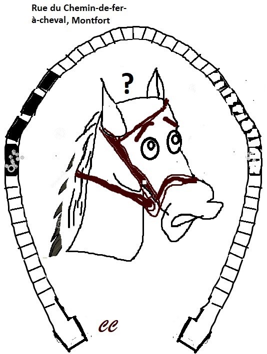
Held on February 25, 2022, by videoconference, with about 50 participants, and chaired by Mrs. Danielle Desjardins, mayor.
Topic 1 - Aerobic corridor, trails, and activities on the lake: speed of vehicles; too many bicycles; too many dogs; behaviour of visitors; too many people on the lake; boats; safety.
(Note: We will replace the names of those who expressed themselves by capital letters; with DD for the mayor).
DD: Presentation of the Corridor and the existence of problems in Montfort, contrary to Morin-Heights or Lac-des-Seize-Îles. Invitation to the participants to express their opinion succinctly.
M: The sound carries far to the lake; visitors are not aware of it.
P: (On behalf of two absentees here.) The speed of some cyclists at the Corridor is the main problem for the safety of residents. DD: No speed bumps on the Aerobic Corridor or the P'tit train du Nord trail, according to the MRC.
N: Is the meeting recorded? DD: No.
A: Is there traffic control? A constable would be needed to ensure that the boats are washed. DD: It costs a lot to employ constables.
A: We should charge for parking, boat washing, etc. DD: The Corridor belongs to the MTQ and is under the responsibility of the MRC. We cannot erect a fence to prevent access to the beach; nor charge for parking. The management of the Pavilion, the Corridor, etc., causes us a deficit of $60,000. We cannot continue like this, at a loss. And it is the MRC that decides everything.
J and S (Patrollers at the Corridor): The regulation applied on the Corridor, in Montfort, is different from the one known in Morin-Heights: case of the prohibition to walk dogs in use elsewhere. But we can ride our bikes everywhere, for free, contrary to skiers. DD: The rules must be standardized.
(In the opinion of the undersigned (CC), dog walking should be part of the exceptions associated with the shared-use path).
C & V: (inaudible)
R :
- The Corridor is public, but we need a constable from Montfort to Newaygo.
- Need to charge for lake access and boat washing; or stick to rental system. We will not be able to control the situation otherwise.
- The MRC is making a mess.
DD: People come here to take advantage of the free wash; then they go to the lake of their choice, where they must pay.
For the MRC, the Corridor is a park that attracts a clientele that can foster economic development.
G :
- Access to the lake is a federal right (CC: more provincial); but the municipality can control access. (CC: Indirectly perhaps.)
- Visitors are not respecting the protection of the lake and are exploiting it at our expense. DD: We need to control access to the lake.
E: In New York State, access is controlled by a reservation system. Here, visitors are allowed to land on private property or docks. DD: We are aware of the situation.
D: Can the Corridor be separated from Chemin-de-fer and run backwards or through the Orphans' Trail? DD: Unlikely, but to be studied. The Corridor uses the old railroad tracks.
U :
- Thank you for this Zoom.
- There is a saturation point for each lake. A study would be needed to determine the saturation point for Lake St-François-Xavier.
- The MRC could then be held responsible for its deterioration, etc., if the established capacity was not respected. DD: This is something to consider.
L :
- The police will not solve anything; instead, we must educate the users.
- Stop the tourist promotion, which does not bring us any money.
DD: If we had control and management.
Q :
- If it wasn't for the Corridor...
- Find a way to manage it all.
- Priorities:
- Environment
- Safety
- Respect for residents
- Government is responsible
CC:
- In support of what we heard: Implement a reservation system. This would control the influx of visitors and encourage the establishment of quotas for parking and lake access. Residents would have priority in the allocation of reservations or a permanent permit.
- The same applies to equipment (boat) rentals.
- Consideration could be given to requiring all visitors to rent equipment on site rather than bringing their boards, kayaks, etc.
V:
- Re-activate the automated gate to prohibit visitors from entering the Corridor?
- Add no parking signs on the Corridor. Because it is winding, it is easy to miss the ones that are there.
- Put up signs indicating that it is a shared path.
- Ensure safety on the lake.
- Too many people on the lake and not enough discipline, e.g. paddleboarding visitors anywhere, etc.
- It is up to the MRC to act.
M :
- People come to wash their boat here, even if they will go to another lake, because it is free.
- Visitors (or delivery people), directed by their GPS to a street that is blocked or that, like Mount Street, has several separate sections, do not find the right way.
A: ?
O: Yes to a reservation system and more control.
Y :
- More safety on the lake and Corridor.
- Cyclists or kayakers do not follow any rules.
- 80% of visitors are from the region, not from Montreal.
- On the Principale, the passage of vehicles lasts all day.
- Put a large sign on the Corridor inviting to limit speed.
Q:
- There is a place in British Columbia where they have a quota and reservation system; this ensures environmental protection and safety.
- Only about 5% of cyclists are going too fast; we should not penalize the majority for the abuses of a small minority.
T: Viking Club members are trained.
P: There are groups of cyclists who take up the entire width of the Corridor and speed. DD: There are even organized groups.
B: If skateboarders and others are forced to ride along the shoreline, they will disturb the residents.
G: Do you think that the people at the MRC know the situation on the Corridor? DD: Those with whom I have communicated know the situation. But there have been too many discordant voices against the MRC. But they will have to move and help us.
A: We need staff to manage, control: constables, etc.
P: I have often pestered the MRC about the problems, but they turn a deaf ear. And everything has exploded in the last two years.
DD: Write me if you have anything to add; negotiations with the MRC will begin.
Without prejudice and pending any corrections you may wish to submit; by Carl Chapdelaine
Translated with www.DeepL.com/Translator (free version) & Linguee
2nd Montfort Consultation Session, Pavilion, parking (report)
(Management of the Montfort Pavilion and parking lots: Too many cars? Delinquent parking? Washing of boats? Use of the Montfort Pavilion by citizens? Purchase of the Montfort Pavilion?)
Held by videoconference on February 26, 2022, and chaired by Mrs. Danielle Desjardins, mayor; with approximately 24 participants.
(Note: We will replace the names of those who speak by capital letters; with DD for the mayor).
DD: (Not being able to assume its restoration, the Municipality had yielded the Pavilion to the MRC for 1$). Its participation in the financing of the specified expenses is still 40% and the MRC would like it to participate, still at 40%, in a new important restoration. The management lease that Wentworth-Nord has signed with the MRC ends on April 30. What should the Municipality do?
N: Would have asked for a summary of yesterday's session and if an action plan would be delivered as a result of these consultations. (However, we did not really hear what N said.) DD: Today's consultations are to be used by the Council of the municipality to make decisions.
DD invites the participants to give their opinion.
D expresses the idea that this is not really the residents' pavilion anymore
Y agrees, stating:
- That the community aspect of the pavilion has been lost. However, there was the Monfort Art Gallery which worked very well; an asset to be jealously guarded.
- That the Pavilion had become more of a place for visitors.
- That it was also used, unfortunately, as a warehouse for boats and various items.
- That, as for parking at the Pavilion, others had chosen to install parking meters that limit the parking time of a car to 4 hours. This would allow a rotation during an overabundance of visitors.
- That a long-term agreement should be negotiated with the MRC so that discussions do not always have to be repeated.
- That, as for buying the pavilion, it would be necessary to know the conditions for the municipality first.
Q :
- The Pavilion is associated with the image of Monfort. The old church is in a way part of the heritage.
- to serve the residents;
- to welcome visitors.
- But in the current discussions, the MRC is a big absentee.
R: In the long term, we would like to be master of our own home; but the presence of benches in the pavilion, for example, does not allow it to fulfill its current vocation.
CC (the undersigned) would like to know about the pavilion in St. Michel; what are the costs associated, for the municipality, with the rehabilitation of this pavilion and its future use as a community center.
Q talks about a heritage building.
CC: It is difficult to imagine a new construction. But the Viking Club has built a new building next door.
L:
- Establish clear responsibilities for each other.
- Clarify the vocation of the Pavilion; like giving more space to the art gallery.
- The converted chapels have often become socio-cultural or community centers.
- MRC or Wentworth-Nord?
- Government assistance programs will have to be sought.
T: In response to our mention of the construction of a new building, she explains that it is, in fact, the use of two containers, we understand.
Y: The Pavilion is part of our heritage.
P:
- Don't build a new building.
- Visitors take up all the space on a busy day. As a resident, I couldn't even find parking to go and look at the art gallery.
A: The MRC has always taken the easy way out when it comes to work or material purchases. While it did this for the Pavilion, we saw investments of a completely different order of magnitude for the Piedmont Pavilion. Why is that?
D :
- Need a long-term lease.
- Difficult to recruit residents for various activities at the Pavilion: classes, coffee hour, etc.
- We can't manage it; it's up to the MRC. We need to take back our Pavilion.
DD :
- It costs us $80,000 to run the Pavilion, etc., while the MRC gives us $20,000. We cannot continue like that.
- Do we want to keep the management of the Pavilion? It seems that your answer is yes.
D: We pay 40%, but we only decide at 4%.
Q: Whether we own the building or not is not the most important thing. It's what you can do that is important.
Y: I've been taking care of this pavilion for 20 years. I see that we are being dispossessed.
B: How much does it cost to buy and manage the Pavilion? D.D.: Several hundred thousand dollars (?)
- Who manages the Pavilion at the municipality? D.D.: Mr. Daniel Thibault.
- Who decides on the repairs, etc.? DD: The Public Works Department takes care of it.
M: Regarding paid parking, couldn't there be free passes for residents?
F:
- Thank you for these consultations; I am learning a lot.
- We should define the vocation of the Pavilion.
- Have a better management of the access to the lake, etc.
- The Pavilion is the central point.
CC: We need revenue to compensate for our costs; but rather than charging for washing, launching (illegal to charge), etc., couldn't we put this in with the negotiation of the percentage of participation of the MRC?
I: We could have a much better and useful Pavilion.
D: in response to our (CC) intervention on the imposition of fees for washing boats. It was the Lake Association that suggested that it be free; to encourage all users to take advantage of it.
P: If there were only boat and other articles rentals in Montfort, there would be no need to wash boats; we would solve the problems of parking, saturation of users at the lake, etc.
A: How much does it cost for the Saint-Michel pavilion?
D: If we owned it, we could charge the MRC for its use; rather than the opposite.
L: We need the MRC for financing.
P: We could make the purchase of the Pavilion profitable.
CC: Risky to buy the Pavilion. If the costs explode, as has been the case since it was taken over from the Coop des 4 Pôles, we would be in trouble. The MRC has a bigger budget.
Q: Talk about management before talking about buying the Pavilion.
H: Give priority to the socio-community vocation rather than the outdoor vocation.
N: When we see the concerns about the state of the dam, it is better not to risk owning it all.
L: If advisory committees were formed on these issues, candidates could be sought from among the participants in these consultations.
Note: This report, made freehand, can only give what we perceived from the participants' interventions. It will be necessary to interview each participant to find out what they really said.
Without prejudice and pending any corrections you may wish to submit.By Carl Chapdelaine
Translated with www.DeepL.com/Translator (free version) & Linguee
3rd consultation session on Monfort: right to occupy, to circulate (report)
Sharing the Railway with the Ministry of Transport. Occupy the premises? Conditions of occupancy? Paying insurance? Traffic?
Held on February 27, 2022, by videoconference, with about twenty participants, and chaired by Mrs. Danielle Desjardins, mayor.
(Note: We will replace the names of those who speak by capital letters; with DD for the mayor and CC for the undersigned).
DD to Z: The original contract stated that the Department of Municipal Affairs owned the old rail line. Why is it now the Quebec Ministry of Transportation?
Z :
- Municipal Affairs transferred it to MTQ.
- By-law 93-99 was supposed to set policy for the Corridor; but MTQ would not have acted on it
DD: It is no longer reasonable to require residents of Chemin-de-fer Street to access their property by water. By the way, the Municipality will make a barge available to residents without road access to Lake St. Francois-Xavier for two weeks this summer to allow them to transport materials and other bulky objects.
CC to Z :
- Right to occupy or to circulate; what is the difference? What is the definition of the right to occupy?1
- Having to renew a permit annually, for residents of the Aerobic Corridor, reduces their property rights and the value of their property.
Z: This is due to the requirement for each of these owners to have annually renewed insurance to protect the Ministry of Transportation in the event of an accident or otherwise.
DD: The MTQ will never grant a permanent right, as this would create a precedent applicable throughout Quebec.
S: The right to circulate, that goes without saying. I have insurance, as required.
K :
- There are several constructions on the Corridor right-of-way, in Morin-Heights, Lac-des-Seize-Îles, Weird, Arundel, etc. It's the same everywhere; you don't need a contract. Wasn't this just a political squabble?
- There is a specific problem with the new parking lot near the beach. It is a dead end that forces a U turn and is a nuisance to neighboring property owners.
- The fixed gate on the Corridor at the end of this parking lot in any case prevents visitors from parking along the Corridor beyond it, as was the case before.
- Parking should be prohibited on this shared way.
DD: Concerning the Newaygo bridge, owned by the MTQ, the MRC would like to impose 40% of the costs of its restoration on us, even though we do not own it.2
H: About the parking on the new section of Mount Street (des Érables?) ...
Z: About the name of the new section of Mount Street, served by Thurson Lake Road: Hoping to solve the problem of visitors and delivery people having difficulty finding their way to the right section of Mount Street, it was suggested that this new section be named Orphans Street. However, there was concern that the name would be confused with the name of the famous neighbouring pathway and the former mayor, Mr. F. Ghali, was opposed to this. The name of Les Érables was then proposed; but the name change does not seem to have been successful.
F: The access to Chemin-de-Fer Street should be reduced.
DD :
- Re-open the automatic gate? This will have to be negotiated.
- The MRC is transferring responsibilities to the municipalities (without sufficient means to assume them).
F: The gate had problems; but since it is out of order, there are more visitors, sometimes lost, or looking to park on the Corridor. Why not manage it like on the P'tit train du Nord track?
P :
- The electric gate could stay blocked and prevent anyone from exiting this landlocked area. It was a public hazard.
- About the right to occupy, we never had the right time. We had the right to build in the first place, and the notaries never advised us otherwise.
- You can't build on the Corridor right-of-way...
- There were never any set rules.
- They can't stop me from driving home!
D: The MRC would have to make an inventory of everything that is built on the Corridor right-of-way. DD: I'll have to ask them about that.
Q :
- The gate also had control over the use of the boat ramp.
- The signage should be cleaned up already.
Z :
- The reset button on the gate system had to be used regularly as it would get stuck. Mr. A. Genest did it almost every morning. Then we realized that we were in danger of touching an adjacent piece and getting electrocuted while doing this. The gate was condemned.
- In response to the suggestion to use uniform rules everywhere on the Corridor or on the P'tit train du Nord track: No! In Montreal, the rules vary practically from one street to another, to respond to different situations. This is also the case in the Corridor; you can't apply the same rules in urban areas as in forest areas, etc.
V :
- The MTQ had concerns about the presence of the (private) marina parking lot and the nearby general store, because of the vehicle traffic generated on the Corridor.
- Today, the GPS brings people to the marina who want to go to the beach, but the road is blocked.
- Signs need to be added to indicate the maximum speed on the shared lane of the Corridor.
- The roadway needs better maintenance.
DD: We need to speak with one voice to the MRC and the MTQ.
Q: It is a bad approach to ...?
D: The marina parking lot is private; but who funded the new one near the beach? DD: The MRC.
N: (Recalling the death of Mr. John Bulmer.) Yes, it is private; I pay my rent to the owner.
P: Concerning the possibility of installing speed bumps to slow down cyclists: Would it bother with the leveling with the plow. DD: No; not really.
CC:
- Installing speed bumps would take cyclists to the hospital, then to their lawyer's office....
- You can go through the small gate when the big one is closed, so what good is it?
W: An internet reservation system, like for ski resorts, would allow for the number of spaces available in the parking lot, on the lake, etc. to be made known, while communicating instructions to users. Aren't we in the electronic age?
G :
- The small gate was in the way for ambulances, etc.; it had to be unlocked.
- Visitors park at the marina and launch their boats near the bridge or find a place to swim.
@: It is necessary to act quickly; March is here, and April not far...
X :
- We can go through the small barrier or wait for a bicycle to trigger the mechanism when passing...
- But, it is sure that there are more visitors without a barrier. If it was operational, it would be nice.
1. In fact, we understand that the rights to occupy and to circulate are inseparable. Originally, these rights apparently referred to the use of the Aerobic Corridor right-of-way for accessory construction (parking space, stairs, etc.) and vehicular traffic on the Corridor itself.
In November 2014, residents served by the Aerobic Corridor shared lane received a letter from the MRC. They learned that, according to the MTQ, their use of this vehicular lane contravened the use that should be reserved for it. Consequently, the MRC des Pays-d'en-Haut and the municipality of Wentworth-Nord worked closely together to allow the issuance of an annually renewable "permission to occupy", which would in a way formalize the right to circulate on this part of the aerobic corridor for its residents and their families... This vehicular traffic was restricted to the residents of this sector.
But the property owners are now asking for a permanent right of occupancy, which is enshrined in the bylaws. Right To Occupy On Chemin-De-Fer As a member of the new Municipal Council, David Zgodzinski would advocate on their behalf and prepare a resolution in support: Report On The W-N Council Meeting Of March 20, 2020.
At the same time, these homeowners were prohibited from expanding their homes or building new homes on land they owned. Since they had no real road access, as required by the Municipality's by-laws, this was logical.
2. The 60/40% cost sharing between municipalities and MRCs in the Pays-d'en-Haut seems to be the norm. But, how to justify, if the MRC can already demand a financial participation from Wentworth-Nord for the repair of its own bridge, the existence of such a norm, when the situations on the ground are often cases in point? Moreover, the municipalities making up the MRC are not equal in terms of financial resources and their sharing in proportion to their population. This is a case in point for this bridge, since the dead-end road it opens only serves a small group of residents; the majority of traffic is now that caused by its vocation as a greenway.
Without prejudice and pending any corrections you may wish to submit; by Carl Chapdelaine
Translated with www.DeepL.com/Translator (free version) & Linguee
3 consultations (ZOOM) in Montfort
Hello to all citizens, residents and vacationers of the great village of Montfort.During the election campaign, I spoke with many people about a number of problems and irritants in the territory. These irritants concern more specifically the management of the Montfort Pavilion and its parking lots, the shared use of the Chemin de Fer and the difficulties encountered as a result of the sustained traffic of visitors on the aerobic corridor and on the trails, the Montfortaine trail in particular.
With Colleen Horan, your District Councillor, I am organizing 3 meetings via the ZOOM platform to discuss your concerns and potential solutions.
The objective of these consultations is to feed the exchanges between Wentworth-Nord and the MRC des Pays-d'en-Haut and to set the table for a constructive partnership for the coming years. Come in great numbers because it is time to have your voice heard by the elected officials who will represent you well with the other political authorities.
Here are the 3 consultation topics, the consultation dates
and the ZOOM links to join the group.
Topic 1: Aerobic Corridor, Trails and Lake Activities
Too much biking? Too many dogs? Vehicle speeds? Visitor’s behaviors? Too many people on the lake? Boats? Safety?
Date: Friday, February 25, 2022, 7:00 to 8:30 pm
1st ZOOM link:
ID de réunion : 835 9958 8806
Code secret : 283382
Topic 2: Montfort Pavilion and Parking Management
Too many cars? Delinquent parking? Washing of boats? Use of the Montfort Pavilion by citizens? Purchase of the Montfort Pavilion?
Date: Saturday, February 26, 2022, 1:30 to 3:00 pm
2nd ZOOM link
ID de réunion : 857 8403 1588
Code secret : 112507
Topic 3: Sharing the Chemin de Fer with the Ministry of Transportation
Occupy the premises? Conditions of occupancy? Paying insurance? Car traffic?
Date: Sunday, February 27, 2022, 1:30 to 3:00 pm
3rd ZOOM link
ID de réunion : 827 5288 9629
Code secret : 116895
Please accept our best regards.
Colleen Horan, Councilor and Danielle Desjardins, Mayor.
Montfort Consultation, Topic 3: MTQ and Right to Occupy
Chemin-de-fer residents' right to occupy and circulate: Permission to occupy on the Aerobic Corridor; Summary Report Of The Council Of Mayors Of March 10, 2020 (Période de questions); Meeting With Vision Wentworth-Nord ; Right To Occupy On Chemin-De-Fer: Our Report; Right To Occupy On Chemin-De-Fer; Report On The W-N Council Meeting Of March 20, 2020, (Période de questions); Parking On Chemin-De-Fer; Report On The Municipal Meeting Of July 10th, 2017
Barriers : The Newaygo barrier ;
Monfort Consultations, Topic 2: Management of the Pavilion and Parking
Articles by Friends :
1. Montfort Pavilion: The Future Of The Montfort Pavilion; David Zgodzinski Wants 100% Of The MRC; At The Montfort Pavilion In 202; Kayaks at the Pavilion; Montfort Christmas Concert Success; Montfort Christmas Market
2. Parking : There was a question from Ms. Colleen Horan to Mr. David Zgodzinski at the August 20, 2021 municipal meeting; It was discussed at the December 17, 2021 municipal meeting; Parking on Chemin-De-Fer; Parking sticker vs MRC; Montfort Beach Fenced
3. Constables : Council meeting of September 17, 2021; Council meeting of August 20, 2021; David Zgodzinski Wants 100% Of The MRC
Par Carl Chapdelaine
Consultations in Monfort, topic 1: The shared way
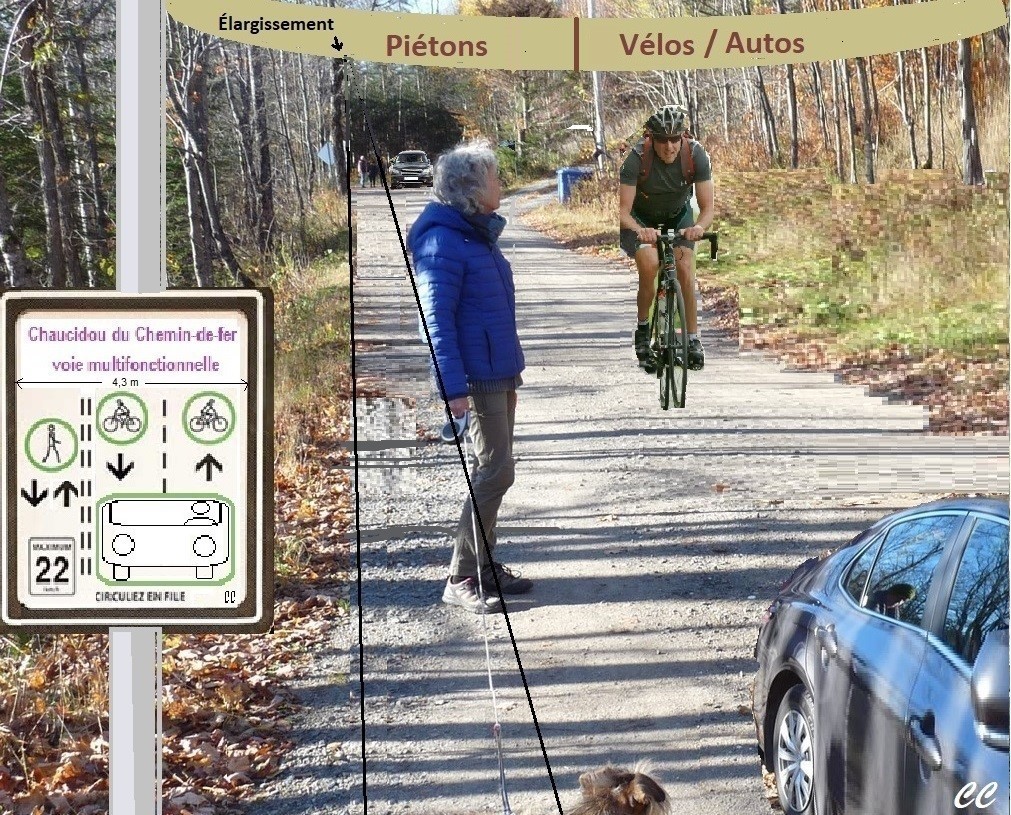
Doesn't the reality on the ground of vehicle, bicycle and pedestrian traffic on the Aerobic Corridor's shared way give a rather confusing picture of an ongoing situation? And does anyone in Montfort know the rules governing the behavior of users on this way? Do such rules really exist? If not, then there is already a problem to be solved. Establishing a regulation to govern this traffic on the current shared road seems to be the elementary solution; the one with the greatest economy of means in any case.
Indeed, to really solve the problem, we could instead consider building a parallel corridor. Chemin-de-fer street would become a street in its own right; still not conforming to today's environmental criteria, but as a lesser evil since it is still a dead end. Improbable parallel lanes, however, because we cannot consider dedicating the current way exclusively to sports activities, since it must serve the residents who have settled there. And developing an upstream trail for pedestrians, bicycles or skiers would pose perhaps insurmountable challenges. The Corridor follows the flat route of the old railroad and forcing users to climb a significant slope would already be a counter-indication. If that's the case, they might as well take the detour via a shortened and redesigned Orphans' Trail, but not along the lake.
Providing separate corridors for various users on the existing path seems a bit more realistic; but it involves an unlikely widening of the path. Blasting, encroachment on private property, acceptance of the measures by the owners concerned, etc., would all be obstacles to consider. The cost of the operation and the choice of its backer, between residents, municipality and mrc, would probably be the most determining among these constraints.
Before we can move forward in one direction or the other, we can already see that we need to establish the costs and implications of the various proposed solutions for the residents and other users as well as for the authorities. A preliminary analysis of the different scenarios therefore seems essential to the choice of the best one. We can think, moreover, that we are not the only ones, in Quebec or on the planet, to experience such a problem. Arrangements have been tried for more or less similar cases in the Netherlands and elsewhere where the bicycle is king; not to mention that certain rules or remedies probably already apply on the Aerobic Corridor or on the P'tit train du Nord trail.
Returning to the solution that does not involve any redesign of the existing road, there are examples of regulations that govern the behaviour of different types of users. For example, a formula called chaucidou, a contraction of chaussées à circulation douce (soft traffic lanes), is applied in Quimper, France. One lane is reserved for vehicles, one for bicycles and one for pedestrians. However, vehicles can move into the other lanes when crossing. Le chaucidou de Quimper But rather than isolating cyclists to protect them from motorists, as in Quimper, the Aerobic Corridor should have a lane for them to share with vehicles. In any case, the speed would be more limited to ensure their basic safety. The chaucidou or its adaptation requires consistent regulation and adequate signage, given the financial means available.
Whether it is a matter of a chaucidou or of another formula applied without redesigning the current route, it seems that the establishment of rules and the control of their application must be considered.
In the meantime, it has been possible to multiply the number of signs encouraging cars and bikes to slow down; it has been possible to propose speed bumps (which would possibly send a certain number of them to the hospital and then to their lawyer's office...), etc. But this did not really solve the problem or address the larger challenges ahead.
By Carl Chapdelaine
Other articles by Les Amis: Shared lanes in the Corridor; Corridor, dogs, bikes; Shared lane: MRC vs MTQ; SQ patrol in the Corridor.
Montfort issues (LSFX's friends index) (draft)
B. Residents' Right to Occupy and Circulate on Chemin-de-fer Street: Permission to occupy on the Aerobic Corridor; Summary Report Of The Council Of Mayors Of March 10, 2020 (Question period); Meeting With Vision Wentworth-Nord ; Right To Occupy On Chemin-De-Fer: Our Report; Right To Occupy On Chemin-De-Fer; Report On The W-N Council Meeting Of March 20, 2020, (Question period); Automated Barrier And Corridor;
C. Parking on Chemin-de-Fer Street (rules, jurisdiction...) Parking On Chemin-De-Fer
D. Maintenance Snow Removal On Chemin-De-Fer: Update; Snow Removal: Update; Snow Removal On The Chemin De Fer ; Newaygo Bridge Closing
E. The shared way, cohabitation: walkers, bicycles, cars, dogs Voies Partagées Au Corridor; Newaygo Bridge Closing ; Voie Partagée: MRC Vs MTQ ; SQ Patrol At The Corridor
F. Barriers
i. Beach Barrier Closed, Barrier Open...
ii. Articulated barrier The Newaygo Barrier ; Automated Barrier And Corridor
G. In times of pandemic Opening Of The Aerobic Corridor; It Doesn't Make Sense!
2. Montfort Pavilion
A. Purpose and Use
i. Socio-community hall
a. Meetings, exhibitions, shows, religious rites, etc. De Florence, Tout Mon Amour; Succès Du Concert De Noël De Montfort!
b. Christmas Market, Artisan Fair and others Christmas Market Of Montfort
c. Municipal Consultations and Communications Public Consultation On The Rehabilitation Of The Road Network
ii. Regional Park/Aerobic Corridor Welcome Station
a. Welcome
b. Kayak and bicycle rentals ... Kayaks at the Pavilion
c. Tourism
iii. Inspection station for boats At The Montfort Pavilion In 2021
B. Cost sharing MRC-Wentworth-Nord David Zgodzinski Wants 100% From The MRC! ;
i. Maintenance
ii. Renovations
C. Revenue?
3. Visitor Influx and Parking
A. Quota and Vignette Vignette Vs MRC
B. Constables and Surveillance
C. Closing of parking lots? Notes On The February 9, 2021 Council Of Mayors Meeting
4. Housing and Development
A. Gentrification
B. Succession
C. Growth plan vs. environment (urban planning measures)
D. The isolation of the sector without road access
E. Preservation of the architectural character
5. Assistance to seniors
6. Lake St. Francois-Xavier
A. Sedimentation
i. The Big Hill vs the protection of the "Church" basin and Lake Chevreuil La Trappe À Sable S'en Vient ; Sand Collector Emptying
ii. Hunter Street Extension
iii. Parking Lots and Oversized Entrances
B. Water quality and eutrophication
C. Invasive species
i. Eurasian Watermilfoil New Measures For The Use Of The Boat Launch
D. Buoys
i. Safety
ii. Protection of the lake
E. Septic systems
F. Access and Monitoring
i. Launch Ramp New Measures For The Use Of The Boat Launch
G. Visitors Stand-Up Paddle Board Riders On LSFX
H.The Beach
I. The Lake Association
J. LSFX Environmental Fund
K. The Dike
L. Lake Support Capacity
i. Coalition Navigation An Instructive Meeting Of The Executive
M.Watershed Protection
i. Lac à la Croix
ii. Thurson Lake Road
a. Justification of the road Le Chemin Thurson À CBC!; Nord-Wentwortois, Access Road, Etc.
iii. Mirror Lake
N. Lake Plan
i. CRE
ii. Mathieu Madison
7. The landscape
A. Camouflage of bins
B. Landscaping
i. Marina parking lot
ii. Properties
8. Tourism? Heritage
A. Tourism promotion of the MRC Aerobic Corridor Park: Park Of The Aerobic Corridor: Development!
B. Remembering the orphanage and the village of yesteryear
C. Remembrance of the railroad
i. The Turntable Park Le Parc De La Plaque Tournante
9. The trails
A. The Orphans Shelter Locked; Orphans Abandoned; Le Sentier Récréatif Du Lac Saint-François-Xavier
i. Maintenance, chores
ii. The Shelter A Night At The Shelter...(before/after) ; Le Refuge Du Sentier Des Orphelins ; Le Refuge Des Orphelins ;
iii. The Belvedere
iv. Interpretation
a. the bog
b. the beaver dam
v. Promotion Guides Touristiques
B. Consultation Public Consultation On Trails, Report; Public Consultation On Trails
10. Culture
A. Galerie d'art Montfort
B. Shows Nicola Ciccone's Christmas
C. Participation
D. Library
11. Socio-community events
A. Potlucks and corn roast Souper-Spaghetti, 24 Août
B. Diana's coffee meeting
C. Montfort Regatta
D. Concerts on the Lake Pontoon Boat Concert
12. Relationship with St-Adolphe-d'Howard
A. Montfort Road
B. Deer Lake
13. Road maintenance and garbage collection
A. Garbage and Recycling The Emptying Of Semi-Buried Containers
14. Environment
A. Electric Bollard
B. Public transit and carpooling
C. Mobile convenience store?
D. Wildlife corridors and opening up (due to Lac-Thurson road, Principale road, etc.)
15. Wildlife
A. A Pack Of Wolves At Lake St. Francois-Xavier;
B. Beaver dams Report On The Municipal Meeting Of June 12, 2017
16. Commercial Development and Private Services
17. Municipal Information and Consultation Sessions
18. Anglophones Inclusion
19. Government and Para-Government Programs The Land Planning Fund (FDT)
TO FOLLOW UP
The future of the Montfort Pavilion (additions)
What will this socio-cultural center look like tomorrow? The Pavilion, an abandoned church that was once transformed into a recreational pavilion, is owned by the MRC. It is used by the MRC as a reception center for the Parc régional des Pays-d'en-Haut, but also by the municipality of Wentworth-Nord, which claimed the management contract in 2018. Not to mention that the Archdiocese also has a user contract with the MRC.
Due to the presence of the Aerobic Corridor and other public trails, the boat wash, the Montfort Art Gallery, the influx of visitors who come to enjoy, among other things, nautical activities at Lake Saint-François-Xavier, equipment rentals, etc., we can say today that the Pavilion meets a significant demand. However, even if the hall of the former church is teeming with activities, its nave, now a community hall, seems to be largely underused. (It should be noted that this influx of people, along with traffic and parking, is a major problem in Montfort). And we do not see how this last observation could change in the short term, given the small population and the rarity of large-scale events in the local calendar.
The Pavilion is due for a major and costly renovation, certainly in the million dollar range. But in what direction and who will foot the bill? The Municipality claims to be paying 40% of the costs for the maintenance of the Pavilion (and the trails, snow removal, garbage collection, etc.?), compared to $32,000 for the MRC, according to the figure quoted by former Councillor Zgodzinski during the presentation of the 2021 municipal budget. This financial obligation was deemed disproportionate by the previous Council. The Pavilion only brings in a significant net expense. The installation of an air conditioning and air purification system including a HEPA filter, if the future is still with Covid, would cost a good $30,000.
However, the Municipality has the choice to leave the total administration to the MRC which dictates the policy anyway. Would this management then return to the Coop des 4 Pôles? This does not seem to be the wisest option, as the Town Council, on the contrary, wants to have the final say in the administration of issues concerning Montfort. With these unknowns, how can the authorities be committed to act and begin the restoration of this providential building? Will the subject be addressed when negotiations resume between the Municipality and the MRC concerning the agreement for its management and related services? And, even if a consensus of opinions among the residents concerned seems impossible, will the latter, those of the "village" among others, be involved in these projections?
But, let's remain serene, hadn't the prefect affirmed to us, at the MRC des Pays-d'en-Haut mayors' council of March 13, 2018, held in this same pavilion, that all these facilities would remain the property of the MRC and that the latter would always ensure their maintenance (restorations and renovations of the roof, sanitary and septic installations, etc., heating, insurance and others)?
Do the two levels of municipal government have reconcilable plans in mind for the Pavilion? There was talk, when the Prefect was rather Mayor, of adding a storage room for rental items or other functions, if memory serves. What is the status of this?
Is there a possibility of refurbishing the former nave? It is obviously intended to be a multi-purpose room; putting up permanent partitions to allow for the creation of multiple rooms would take away the ability to hold meetings, performances or other well-attended events. The sacristy, which has also served as a kitchenette for corn roasts, is too small to serve as a backstage area for performances. The rood loft, converted into an art gallery, where local artists often have the opportunity to exhibit their latest creations, does not lend itself to much overflow.
One might even wonder if a new construction, according to plans tailored to the desired orientations, would not be more advantageous. Loss of a piece of heritage to regret? And how can we fully justify, to the Council of Mayors, an imposing financial implication, even with a participation of the Municipality; when the latter refused to contribute to the setting up of the Pays-d'en-Haut Sports Center?
But let's go back to Mr. Dave Clark's perception of the approach to solutions in the face of the challenges created by the presence of this same Regional Park next to the very attractive Lake Saint-François-Xavier. Considerations concerning the future of Montfort Pavilion will have to be intimately linked to decisions that should be made in a global vision of the situation that prevails in the village. And that will require, above all, the approval of the residents who will have to live with the choices made by the authorities.
An additional and often disturbing variable in these considerations is the need to appeal to higher government programs to participate in the financing of such an undertaking. These programs impose criteria that may often address concerns other than those contemplated by the developers. If a project were on the table today for the rehabilitation of the Pavilion, the municipal authorities or an ad hoc non-profit organization could, for example, appeal to the Canadian Community Revitalization Fund - Quebec, from Canada Economic Development for Quebec Regions. Here, the eligibility of applicants is based on very specific post-Covid goals and criteria such as:
- building new community infrastructure and revitalizing existing assets;
- bringing people back to public spaces safely as health measures are relaxed;
- creating jobs and stimulating local economies;
- adapt community spaces and assets for safe use in accordance with local public health guidelines;
- build or improve community infrastructure to encourage Canadians to re-engage with and explore their communities and regions.
- And so on.
So it would take a fairly substantial extension of the pandemic and the program, and especially the promise of substantial benefits, for a project with Montfort Pavilion to be submitted, after adaptation.
Another program provides a grant of $100,000 for the development and upgrading (?) of the old church of Saint-Michel, according to an allocation that, in June 2021 and under the recommendations of the Advisory Committee for its transformation to its new vocation, remained to be determined by the City Council. Or, a $22,055 grant for the renovation of the church's kitchen, under the federal New Horizons for Seniors Program.
The problems and the actors seem so numerous and divergent in the issues at stake in Montfort that it is a real brainteaser…
Translated with www.DeepL.com/Translator (free version)
Plus: At the Monfort Pavilion in 2021 The Montfort Pavilion
Par Carl Chapdelaine
Monfort: a village on the border
Won't the Montfort of tomorrow straddle two municipalities? One hardly realizes that, a stone's throw from the village entrance, one is in Saint-Adolphe d'Howard. You follow closely the municipal news of Wentworth-Nord, and yet, what do you know about what is happening, not in Laurel, not in Saint-Michel, but just nearby your home, where you drive quite frequently? You are involved in the protection of Lake St. Francois-Xavier, and yet you may not be aware that the trout you released there went into its outlet, Lake Chevreuil, and that fishermen were meeting there.
Your environment is zoned as housing, commercial space or green land; all this is registered in the municipal urban plan and must ensure the harmonious evolution of Montfort. But, we build on Chemin Sainte-Marie, north of Route Principale or at Lake Chevreuil according to perhaps completely different criteria. And what is the only village in the area; the only old and future service center? What are the links between the residents here and there? The territorial boundaries here have created a virtual border that, while it may be expressed in the local topography, with the sharp drop in elevation that we know, makes little sense in terms of neighborhood.
The fact that there are no more services in Montfort; that probably all the inhabitants of the sector do business in Morin-Heights, in Saint-Sauveur or, for the vacationers, in their place of origin, except for the municipal services, does not encourage us to become aware of the situation. And if Wentworth-Nord still wants, at the will of its future council, to use an improved Route Principale as a development axis, it may be necessary to convince Saint-Adolphe to do more with Chemin Sainte-Marie, which, along with Chemin Montfort, is its main access road.
But inter-municipal exchanges do not seem to be the priority at City Hall these days. Mayors and their councils are being given more power over their territory, and they are jealously guarding it. Some of them seem reluctant to consult their neighbors. And, tell us, who is the mayor of Saint-Adolphe-d'Howard? (It's Claude Charbonneau.) And yet, draft bylaw 2017-498-10 (changing the distance from 60 to 0-15 meters from waterways) alerted the neighboring municipalities of Morin-Heights and Wentworth, we are reminded.
Aren't we being too territorial? There are lake problems; not Lake Notre-Dame or Lake Saint-Victor; not even Lake Miroir; even less Lake Chevreuil; no, Lake Saint-François-Xavier; even if the problems and their eventual solution are probably similar there...
And if by chance, a Montreal household or other, or even a developer or industrialist, is looking to settle in the area, near a lake or along Route Principale, might not the comparison between the level of taxation, the hospitality programs, the regulations and the municipal services of one or the other municipality influence their choice?
Shouldn't there be some mechanism for consultation between the administrations of the two municipalities on issues, including urban plans, that would concern the Grand-Montfort of tomorrow? Such a mechanism would also cover Wentworth-Nord's relationship with Lac-des-Seize-Îles or any other neighbor. Yes, but isn't the MRC des Pays-d'en-Haut there, via its Schéma d'aménagement et de développement, to coordinate the actions of the municipalities in their bordering zones? Nothing seems to appear on our questioning with this concept.
The rapprochement will perhaps come from the associations of Saint-François-Xavier and Chevreuil lakes. These two cannot really be dissociated; but the latter must essentially suffer what happens to the former. Yet, we might learn more about Lake Saint-François-Xavier by sampling the water in Lake Chevreuil; by noting what lies dormant on its bottom and may have come from its tributary; by examining its aquatic flora and fauna; or by consulting those who are already involved.*
*On the eve of municipal elections, in a call for awareness and collaboration to municipal elected officials and citizens of the 38 municipalities in the Rivière du Nord watershed, Abrinord emphasizes that "all water that reaches the ground is (here) drained to the same river. ... (That) the activities practiced and the decisions related to development are likely to influence (its condition) in quality and quantity."
In 2017, Abrinord, in consultation with municipal and other stakeholders, presented a Plan d'action de cours d'eau pour la rivière à Simon, of which Lake Saint-François-Xavier is one of the headwater lakes. Water quality at SIM 23
Water samples, taken at the bottom of Chemin Lisbourg, at the outlet of this lake (temporary station SIM 23 of the Simon River), in 2017 and 2018, were analyzed for their physicochemical data and bacteriological quality; but the undersigned does not know how to make the comparison with the data obtained at the lake in the framework of the RSVL. One can however imagine that the contribution of pollutants, including road salts, and formerly trapped sediments, transported by the water channeled to the "church" basin by the "Big Hill", had an impact on the quality of the water at the SIM 23 station, and thus at Chevreuil Lake.
Translated with www.DeepL.com/Translator (free version).
By Carl Chapdelaine
Relaunching the railroad in Argenteuil?
An article in the September 2021 edition of Main Street (p.19) gave us a heads up. The Argenteuil MRC is asking the federal and provincial governments to contribute to the financing of a study on the revival of the rail link that existed between Montreal and Gatineau. In fact, the Québec-Gatineau Railway (QGRY) is a line that operated on "450 km of a former Canadian Pacific line between Quebec City, Trois-Rivières, Laval, Lachute and Gatineau" Wikipedia.
The MRC has fought for decades to maintain this rail corridor. It is time, today, in view of the demographic growth of the region as well as the metropolitan population, and the awareness of acting in accordance with sustainable development, to revive the use of rail for passenger transportation. Le Droit
Faced with the congestion of the Laurentian Highway and its impact on the environment, notably through the production of greenhouse gases, is the return of rail transportation possible in the Pays-d'en-Haut?
Translated with www.DeepL.com/Translator (free version) & Linguee
By Carl Chapdelaine
Parking on Chemin-de-fer
A new no parking sign has appeared at the end of Newaygo Road, at its intersection with Chemin-de-fer Street, stuck against the Prestigious Little Gate. It actually says that only residents have this right. On the other side of the road, on Chemin-de-fer/Aerobic Corridor, there is also a small sign indicating a parking ban. The first sign is under the jurisdiction of the Municipality, the second under the jurisdiction of the MRC, it seems. But these prohibitions are confusing. Since when is there parking reserved for residents, and where? And is parking on Chemin-de-fer/Aerobic Corridor prohibited? What do we do with our visitors when there is no parking?
The municipality tells us that the residents-only sign was put up to address a problem at that particular location where residents could not park (or perhaps because offenders were occupying the small parking space there), but even on the back of the sign, we don't see that explanation. As for the other sign, we would have liked it to be identified with the colors of the MRC and that the residents, the Sureté du Québec, and the future constables of Wentworth-Nord, if they have authority on this territory, could know the regulations? Mr. L'Heureux, the new person in charge at the MRC, indicates that parking is normally prohibited on the Aerobic Corridor. However, he offered to check and get back to us regarding the parking issue in Montfort. It seems to us that the MRC should perhaps also have a sticker system or an agreement with the Municipality and its future constables to regulate parking in Montfort.
By Carl Chapdelaine
David Zgodzinski wants 100% from the MRC!
In a circular e-mail, District 5 Councillor David Zgodzinski once again denounces "the cost of the MRC tourism business" in Montfort. Recalling that the Municipality and the MRC des Pays-d'en-Haut had a first negotiation session under the mediation of the Ministère des Affaires municipales et de l'Habitation (MAMH), the councillor hopes that one of the major problems between the two entities can be discussed in the coming weeks: "the management contract to oversee the MRC tourist business in Montfort and the payment of the many functions required by the MRC".
Zgodzinski says the municipality pays 40% of all garbage and snow removal costs in all MRC parking lots; 40% of electricity, telephone, internet, municipal taxes and eventually repairs for the Pavilion, which is 100% owned by the MRC. The municipality must pay "to groom the Aerobic Corridor for cross country skiing in the winter and maintenance of the trails in the summer..."
The municipality must, in addition, pay "to have full-time staff washing boats because of the huge influx of tourists." It "will now have to pay for full-time constables to make sure that the beach is not overrun and to stop unwashed boats access to the lake."
In short, "the MRC is forcing the residents of Wentworth-Nord to pay for the MRC tourist facilities"
"The municipality lost over $58,000 last year managing the MRC tourist business. If that trend continues, and we add the cost of the Constables, the municipality will lose about $100,000 this year. "
"I have been urging the municipality to insist that the MRC pay for all of the tourist business functions – all of the expenses. Until now, the council has been reluctant to push the MRC to do so. "
"Certain members of the council don't want to battle the MRC over the money we lose protecting the environment and the residents from the tourist business. There is a perception that we will need MRC money for other projects in the municipality, for instance a museum in St. Michel, or greenhouses in behind City Hall. So they feel that we shouldn't antagonize the MRC because we may need to beg them to provide a bit of money for future white elephants."
"The municipality has faced up to the responsibility of defending the residents and the environment. In my opinion it's time that the MRC faces the responsibility of paying the cost of all this. If you feel the same, please let the Council members and administration of the MRC know."
Note: The councilor never recalls, in his recriminations against the MRC in this matter, that he was the ardent promoter of the replacement of the Cooperative des 4 Pôles by the Municipality in obtaining the bulk of these contracts. For him, among other counter-indications, these contracts gave the Coop much more money than it should have received "and thus covered the losses of the tourist activity, at the expense of the municipality. Today, he would prefer not to renew them.
Didn’t the municipality had acted with full knowledge of the facts when it asked the MRC to manage the Montfort Pavilion? It had to fulfill the same obligations as those required of the COOP des 4 Pôles. It was undoubtedly a bad decision by Mayor Ghali to persist in this direction.
With all reservations; by Carl Chapdelaine
Translated with www.DeepL.com/Translator (free version) & Linguee.
Our gladiators...

Montfort popularity

We learned from the receptionist at the Pavillon Montfort that the crowds were very strong there the day after New Year's Day 2020.
Groups of tourists, mainly from France, put on snowshoes and set off to conquer our trails. Conditions then seemed ideal and hopefully the current warming will not affect them.
Meanwhile and lees idyllic, many locals would hop on their roaring snowmobile pacing up and down Lake St. Francois=Xavier.
How did the tourist learn about our beautiful corner of paradise? Wouldn't it be important to get all visitors to fill out a short questionnaire or to interview several to find out where they came from, what brought them here and what they came to get there?
If the present is a guarantee of the future, this trend should be accentuated. Montfort will become a known and appreciated destination in our Laurentians.
By Carl Chapdelaine
The steam locomotive sandbox
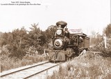
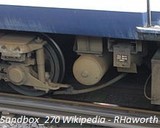
A photo of a steam locomotive of the Montfort colonization railway was posted in the Pavillon Montfort1 Mr. Gérard Chartier tells us about the funny dome on the top of the locomotive; it is in the shape of a German soldier's helmet of the 1st and 2nd Great Wars. It has a delivery pipe on each side that goes down to the wheels. "Do you know what it can be used for?" Well; it is a sandbox that the driver operates to drop some on the rails and allow the wheels to adhere better if necessary.
The friction of the wheels against the rails is minimized by the use of steel; which allows the locomotive to pull heavy loads. But, for moving off with a heavy convoy or going up or down a hill and probably in winter, the driving wheels of the locomotive need more grip. Since the beginning, the steam locomotive has been equipped with various sanders2 to bring the sand right onto the rail by gravity. The sandbox contains calibrated and dried sand.
On the pictures of large locomotives, we often see many of these domes whose base must marry the cylindrical shape that support them. It is not obvious to the layperson whether it is the steam dome or sandboxes. (But in America, locomotives would only have one, according to Wikipedia, and it could be above the steam dome to be heated. Newer models could use air pressure rather than gravity.) And Mr. Chartier has not yet explained to us how we could fill these...
- That which appears on the leaflet "Wentworth-Nord: de grands espaces" and on the large panels deployed at the beginning of October.
- Locomotive sandbox: https://en.wikipedia.org/wiki/Sandbox_(locomotive)
With Google Translate and Linguee.
By Carl Chapdelaine
The railway turntable
The current Park of la Plaque tournante, in Montfort, recalls the existence of such a facility of the Canadian National for the turnaround of the locomotive when a convoy ended its trip to this village. Mr. Gérard Chartier remembers how the engine used for this wheelhouse operated. He was driven by the steam of the locomotive to reorient; the latter being connected to the engine by a hose. He had seen the operation many times.
The details of the operation of such a hub can be found in Wikipédia and elsewhere. It is explained that there was first a circular pit (about 4 feet deep at Montfort). A steel bridge, balanced on a central pivot in the pit, could be oriented in all directions. A mechanism made it possible to align the rails on the exit lane and to lock them in this position.
If, at the ends of the bridge, were steel wheels that traveled on a circular rail around the circumference of the pit, we had there the continuous girder design (three points design). It was the standard design and the one used in Montfort. This distributed the weight of the locomotive with its tender rather than seeing it fully supported by the center pivot (cantilever or center balanced design). On a continuous girder design model, the operator had to move the locomotive forward or backward to balance the weight of the whole on the bridge. There was also an articulated model (center hinged); so that the weight of each of the two sections (spokes) of the bridge, from the central pivot, could be rebalanced to prevent an excessive load be more on one end than on the other. On the Montfort's turntable, the biggest locomotives, with their huge wheels, would use the full length of the bridge.
At Montfort, the mechanism of rotation of the turntable was actuated by a pneumatic motor (i.e. compressed air), fed by the locomotive which was on the swing bridge. "The operator of the turntable was connecting a pipe connecting the air compressor of a steam locomotive to the engine of the turntable ..." Trains are fun
Some operators of the Montfort turntable could let the young people get on the bridge to give them a special experience on this improvised carousel and thus prefiguring the current vocation of this place. To achieve their ends, the young people sometimes had to rather take advantage of a moment of inattention of the operator by hiding behind the locomotive.
A visitor at the Montfort Pavilion, during the last weekend of culture days, showed Mr. Chartier a photo that revealed a small section of the village's hub. There would be nothing to draw from it; but we could perhaps reconstitute the whole with the help of this photo.
Greenport Turntable: Oyster Bay turntable
The Steam Train in Montreal: Old time trains
With Google Translate and Linguee By Carl Chapdelaine
CN's water tower pump
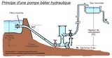
At the time of the steam locomotive, what could make the pump propelling water into CN's water tower at Deer Lake? Mr. Gérard Chartier searched in his memories without being able to retrace exactly the answer. But he knew there was no electricity in this facility. It could not therefore be an electric pump or running on diesel; only the power of water should be in question.
It is perhaps after descending into the vault under the vanished cistern that he finally found the explanation; then the appropriate terms in the dictionary. It was a hydraulic ram pump. There’s nothing left of this pump in the vault today.
It can be deduced that the water arrived under pressure through the pipe coming out from the bottom of the visible part of the dam located at the Lake Chevreuils outlet, on the other side of the railway with respect to the water tower. The elevation between the ground where it was located and the level of the Lake being less than one meter, and the pump being in a vault of more than one meter deep, it should therefore already be under the water level of the Lake, raised by its dam.
A little like the cycle of a piston engine, a valve closes suddenly in this assembly that constitutes the hydraulic pump and where the pipe ends. Water coming under pressure then gives a water hammer on the valve, as when closing a valve that is not equipped with an absorption device. It is this kinetic energy that raises this water in the tank by a vertical pipe, equipped with a non-return valve. Then the pressure returns to normal and the spring valve opens so that the cycle can start again. This device therefore does not make any use of fossil energy or other; it may be the green energy sought today. The maintenance costs of the hydraulic pump are also minimal. At the time, the presence of a lake or a river favored this type of installation. Wikiwater.
Note: Mr. Chartier also has an explanation for the operation of the turntable. Is the steam of the locomotive the source of the needed power? To be continued…
By Carl Chapdelaine
The miseries of the Montfort train
This information and anecdotes from the past are from Peter Murphy's second article in a series of three, entitled "Trains up North", for Canadian Rail.* Old photos illustrate the article.
The first railway line, three feet wide and joining Lac-des-Seize-Îles in 1895, had evidently required the Montfort Colonization Railway Company to break through a lane in the forest. It is said that the stumps and roots were used to partially fill the depressions along the way. This would be the source of multiple subsidence of the soil that we would see later, after the wood would have rotten.
Because of the tight curves and steep slopes to cross, the section of the rail from Morin Flats to Sixteen Islands Lake was at least difficult to navigate; even for a narrow gauge train, said more suited to this type of terrain. The difference in level between Chevreuil Lake and Saint-François-Xavier Lake remained a challenge; even once inaugurated the wider railway standard. On December 7, 1897, the train, this time from the Montfort and Gatineau Colonization Railway, would go as far as Huberdeau on these new tracks. But in 1902, the bankrupt company was to be bought by the Great Northern Railway Company of Canada, which merged to become the Canadian Northern Quebec Railway (CNorQ).
Freight was almost entirely made up of sawmill wood, to which would be added some ore for a certain period (probably between 1916 and 1926 for the transport of china clay). But this cargo, like the passengers, was originally to be transferred to CPR trains at the (Old) Montfort Junction, in Saint-Sauveur; a delay and costs that made the whole operation and products uncompetitive. A CNorQ own section was later built from Saint-Jérôme to Saint-Sauveur to join the line going to Huberdeau; and the company undertook at the same time to build one towards Montreal. While waiting for this extension to the Big City, the passengers would take the CPR train from the Place Viger station, in the metropolis, to get to the (New) Montfort Junction, in Saint-Jérôme, and switch on the CNorQ train for Huberdeau.
In 1919, the company obtained a promise of subsidy to extend the railway to the Gatineau River. It was planning to use the 9 miles of private track of the Canadian China Clay Company's mines, through St-Rémi-d'Amherst, which it had partly redeemed or rebuilt. But the 2.33-mile section of Lake Remi was deemed non-compliant with the standard required by the government, which withheld its grant. It was only when the railway became the property of the Canadian National Railway that the latter brought, in 1926, this route to the required standards.
The previous year, the CNR had built its own route between Saint-Jérôme and the Terminal Tunnel, on Lagauchetière Street, which will become Central Station and where all CN trains will converge. The train could then cross without transshipment the 93 miles that separated it from Lake Rémi.
Memories of the time of the first Montfort train are rare. But some patriarchs have told stories to make hair stand on end. The old father Ducharme, a Montfortain, praised for his part the qualities of promoter of Curé Labelle, who had managed to implant the agricultural orphanage of Montfort in a "desert of rock", where one would not even think to have a kitchen garden...
The Huberdeau branch was going to be in a "sand desert" instead. During the winter of 1912-13, when the train was the only link between this place and the rest of the world, a snowstorm blocked the way for more than a month, depriving the orphanage of food and other essentials. The Fathers would then make sure to make enough provisions in the fall to no longer have to live such a situation.
In the 1940s, double headed steam engines were the rule. Each locomotive was operated separately; it required great coordination and extreme vigilance. The engineer of the second locomotive of a convoy which left Lac-des-Seize-Îles suddenly actuated the whistle of alarm. Always on the alert, he had seen that a driving wheel of the lead locomotive was coming out of its axle. The team of technicians, probably from the Angus workshops in Montreal, took two days to repair everything on site. The lead locomotive had previously been detached and the train had been able to move back to its starting point.
The first locomotives used were light; they were better suited to accentuated curves, light bridges or trestles, such as Newaygo's. After the purchase by the Canadian National, the locomotives were more powerful.
Until trains are equipped with air-brakes, «the brakemen had their work cut out for them, especially down the steep grades on the southbound runs». «While the trains were always operated in a safe manner, passengers frequently complained of the slow speeds on the northbound runs, the time wasted in doubling the hill at Lac Chevreuil and Montfort and the lengthy stop for water at Lac Chevreuil. The prolonged station stop at St. Jerome was another irritation. After detraining and entraining passengers, the train would move ahead a short distance to load unload express.»
At Montfort, we did not really wonder when, but rather, if the train would arrive; and its approach, with the cloud of steam and noise, did not go unnoticed. Everything was then done smoothly. «The helper engine was cut off the head of the train promptly, some of the cars were also dropped on the siding and the remainder were hurried on toward Lac Remi.»
The most enthusiastic passengers were undoubtedly the skiers of the 40s and 50s. However, the trains were so crowded that some had to be content with the baggage car. The return of these exhausted ski enthusiasts was done in the same conditions. In summer, the clientele of the weekend was different.
Motor car was changing the game. And even the arrival of diesel, which did not have the constraints of the steam engine, would not shorten the length of the journey enough to ensure the maintenance of the customer and therefore the service; especially after the opening of the Laurentian Highway.
Summary by Carl Chapdelaine
With the use of Google Translate and Linguee
CNR's Water Tower
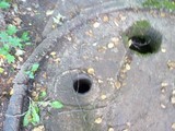
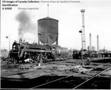
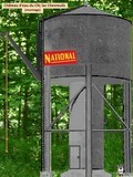
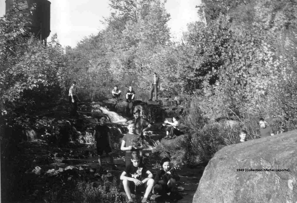
Note: The last photo is of the Lac Chevreuils water tower.(Could someone point out where the boys are and why a small waterfall seems to be coming from the direction of the water tower).
Mr. Gérard Chartier describes what he thinks he remembers of this water tank that fed the steam locomotive at the water station of Deer Lake outlet, not far from the little blue bridge. His brother has a picture. This location benefited both from the proximity of the lake and the railway. The distance between the Montreal station and the water tower probably also corresponded to the capacity of the locomotive's water tank, explains Mr. Chartier.
The four concrete bases that supported the feet of this huge metal tank (galvanized steel?) are still visible on the edge of the Aerobic Corridor. There is also the concrete vault, more than a meter deep, located under the tank and housing the pump that drew water from the lake to the tank.
An articulated pipe was coming out of the tank (the precursor of the Canadian Space Shuttle Arm probably ...) By handling it with a rope, the driver, mounted on the bridge of the locomotive, above the wheels, placed the spout on the opening of the water compartment. Could there have been tenders with a water tank (car attached or fixed to the locomotive and having a coal compartment and possibly a water tank)? (The Spadina water tower in photo, with greater pressure, used an underground pipe that fed a pipe-pole near the track and by which the locomotive was located.)
Between the base and the tank perched on its four feet was a cockpit with a charcoal furnace to heat the water in the winter and prevent it from freezing. There was a station, farther on the way out of the little Blue Bridge, where, in the winter, the employee in charge of feeding the furnace lived. (We could not find any trace of it.) The train could leave there or pick up passengers.
Some young people climbed the ladder to get on the top of this water tower. But as its roof protruded from the wall of the tank, you were forced, like a mountaineer, to lean heavily backwards to get around this ledge; M. Chartier could not risk it.
There were 1,800-gallon locomotives; others of 2,500 gallons. Sometimes two locomotives pulled large convoys. Occasionally, the train had to be split in two in order to overcome the difference in level between Lake Chevreuil and Lake Saint-François-Xavier; or two trains were following one another. In the first case, the locomotive then descended the slope backwards to pick up the rest of the cars. The locomotive’s wheels could too often spin in the slope; wearing rails and steel wheels. During the weekends, at that time, hundreds of visitors were taking this railway line, says Mr. Chartier.
There had probably been a wooden water tower before; certainly enclosing a huge metal tank. You can see such a water tower in Sainte-Adèle old station on the photo (attached), posted near the bridge that spans the last section of Lake Chevreuil. A similar poster might remind us of the existence of our water tower at the place where it rose so majestically; it would also be a good part of a heritage circuit.
One end of the pipe that was certainly feeding the water tower of Lake Chevreuil from the outlet of this lake, which passed under the railway, is still visible at the foot of the small dam. The latter raises the level of the lake and probably ensured the smooth running of the system.
With Google Translate and Linguee
By Carl Chapdelaine
History of the Montfort Railway
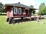
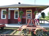
(Report on the presentation of Mr. Claude Martel, held at the Montfort Pavilion on May 26, 2019.)
It is in the context of his academic research that the geographer-historian Claude Martel has built up an impressive historical database of Quebec's railways. Over the years, he would add many analyzes and historical records, along with cartographic collections and photos. Aware of the duty to transmit the results of his research, he and another geographer, Yves Fréchette, founded the Quebec Railways Historical Research Institute.
The presentation of the history of the Montfort railway by our speaker is therefore only a chapter of this quasi-encyclopedia of the railway in Quebec.
Since the beginning of the colony, the waterway was the main means of transporting goods. The emergence of the railway in the country in the years 1826-27 opened up much more practical prospects for the transportation of wood, grain, butcher's animals, milk, etc. And while the rivers were frozen in winter, the railway would eventually be open year-round. The Post would be quickly associated with the deployment of the railway across the country. (In 1987, the old relocated and restored station of Arundel took over this post office function.)
The Champlain & St. Laurence RR, financed by the owner of the Montreal brewery, John Molson, will be the first railway company in Canada. Its Saint-Jean-sur-Richelieu - La Prairie line was designed to bypass the Richelieu waterway linking Lake Champlain to the St. Lawrence River in Sorel. It greatly reduced the duration of the traffic between Montreal and New York. Then there is the Grand Trunk Railway, which connects Montreal to Toronto. The Montreal Northern Colonization Railway Company, whose purpose was to connect Montreal to Saint-Jérôme, would be at the origin of the "Train du Nord", as the famous Curé Labelle called it. It will later be bought by Canadian Pacific Railway.
Unlike today, there were many small companies at the time; but with limited financial capabilities. And as you can already see, in the world of rail, English was the norm.
The choice of the width of standard railways for trains and trams takes us back to antiquity. It was going to be, as in Europe, 1,435 millimeters, that is 4 feet, eight inches and a half (4'8½''). And why this dimension? It was copied from that of the Roman road; to allow then the circulation of the chariots. (But there were larger ones, for more stability, and narrower ones.)
The Montfort railway was created with the obvious purpose, among other things, of francophone and catholic colonization of the territory south-west of the already colonized Saint- Jérôme – Labelle corridor by the Train du Nord. It would start from the first Montfort junction, at Piedmont (Saint-Sauveur), to connect there to the Train du Nord a railway that would go to Huberdeau (Arundel) and Lake Rémi. It was first with 3' spaced rails or what was called an economic railway. The Montfort Colonization Railway Company was going to take advantage of the passage of a Témiscamingue railroad to standard size to recover the necessary equipment for its own railway. This narrow gauge, explains Mr. Martel, with the small locomotives and wagons that would use it, was actually more suited to a hilly area and a winding course. This railway would be very important at the time when Montfort was a much bigger village than today. There was even a theme song for the "Montfortaine", on the air of the Marseillaise.
In 1895, the train was already going to Sixteen Island Lake. Freight transport was critical to the profitability of the company, and there was still a desire to cast a wide net. But the line was still not profitable; while there was thought of extending the railway to Lac Simon and the Gatineau Valley. The Montfort & Gatineau Colonization Railway would replace the original company; however, it would be bankrupt in 1902. The Great Northern Railway of Canada, which would link Rivière-à-Pierre (a station on the Québec – lac Saint-Jean line) to Hawkesbury, would purchase the track and equipment. Then it would merge to become the Canadian Northern Quebec Railway.
Given the 3-foot spacing of the tracks, the transshipment of goods at Montfort Junction, where the Petit-Train du Nord (CPR) tracks were of the standard type, was still a problem. The narrow-gauge tracks were also associated with a standard of 56 lbs; much less than that of standard tracks. It was quickly considered to adopt the standard gauge; that was done in the summer of 1897. In 1907, the company developed a track (13 miles) between Saint-Sauveur and Saint-Jérôme. The Montfort Junction will be moved to the southern suburbs of Saint-Jérôme, where the new railroad crossed the CPR’s tracks of the same standard. The right of way of a section of the old narrow section is still visible in Piedmont (Saint-Sauveur).
The company's railroad has no proper link through the North River Valley to go directly to Montreal; but it has one that joins Joliette. One must make a detour to the east to reach the big city (at Hochelaga). It will take 5 hours to get from Montreal to Arundel by train. For the traveler, it may be more advantageous to transfer on the CPR train at its junction with that of Montfort.
The train schedules show the large number of stations or flag stops that existed at the time. It is that the era of vacationing has begun; we first see the Anglophones of West Montreal to initiate the movement.
With the First World War, three large companies went bankrupt, including the Canadian Northern Quebec Ry. The government must take-over by creating the Canadian Governmental Railway, which will become the Canadian National.
The speaker now introduces us to the "railway operation" aspect of his subject; with the type of material used. We are at the steam locomotive; different sizes identified by the number and size of the wheels. There are passenger cars, first and second class; then the baggage car; not to forget the box cars and flat cars for freight. The locomotives are fueled with wood; then to coal. There were water stops, water stations, water tanks, usually at the stations, or some tank ponds for the locomotives. At the orphanage of Lisbourg (Montfort), they took water from the pond which also served as a pool for orphans.
The "economic activity" aspect follows the previous presentation. The train runs first from Monday to Saturday; reflecting the importance of freight activities. From 1915, with the rise of the resort and leisure travel, appear the weekend trains. In 1927, the "Petit Train du Nord", with its "snow trains" transports hundreds of amateurs per trip. Among the most popular stations then, there are Saint-Sauveur, Shawbridge and ... Montfort! There is also a summer schedule; with multiple stops. The Montfort line is then said to be the most picturesque in Eastern Canada.
With the beginning of the thirties, following the economic crisis, a rationalization of the traffic is essential. Fewer trains but appears the train going on Friday night and returning Monday(?). At the beginning of the 1950s, the popularity of the automobile and the bus, with the deployment of the road network, signaled the hour of the decline of the railway. The daily service disappears; while remains that of the weekend. The closure of the orphanage of Montfort, decreed in the mid-1950s, will precipitate the end of the Montfort railway, as the decline of the village itself.
As for freight, we are mainly talking about wood and some mining products. The diesel locomotive will succeed the steam locomotive; but this type of train will prove poorly adapted to the Montfort railway.
Mr. Martel slips a word about the need for siding and/or rail yard near the stations, for some turntables or, failing that, turning triangles (Y) to allow reorienting the locomotive. These last works sometimes required feats of genius; like to build a Y on a river, for lack of a more suitable place (in Huberdeau?). The only turntable of the Montfort railway was located at the site of the current park that bears this name, in Montfort. The train must also take into account the speed limits to be respected in the curves and the unevenness to be crossed.
Few original stations still exist today; that of Lac Rémi is one of the rare exceptions.
Note: Given the breadth of the content of the presentation, we apologize for having presented only some specific points.
More: Canadian Rail, no 135, 1962
By Carl Chapdelaine
Google Translate and Linguee
The Algonquin in winter
Nomadic, the Algonquin of our regions would have plenty to do in adapting to the transition from summer to winter. Today, we can see that our camping, reflecting our interest to relive a bit like once in nature, and some of our sports equipment inherited from their practices. With the onset of the cold season, they leave the bank of watercourses where they were gathering together during the summer season and where they were engaged in fishing and picking, to enter by family groups in the forest *.
More meat eaters than sedentary Indians, they hunt small as big game to feed, clothe, make their wigwams (among the tribes living further north), snowshoes, some tools and weapons, etc., or store beaver and other fur-bearing animals skin for fur trading with Whites. In the spring, in fact, several would paddle down the Red River and its tributaries to camp near the mouth of the "Petite-Nation" River, on the banks of the Ottawa River, where they would engage in commerce with other Aboriginal peoples and then later with the French coureurs des bois and voyageurs.
"The clothes that wear the Algonquians are very practical because they keep warm and they are durable. When it is very cold, the Algonquians carry a long overcoat made of seven or eight beaver pelts." But bear fur that they hunted during their dormant period was also popular for making capes (sleeveless clothing). Centre for Indigenous Peoples’ Nutrition and Environment (CINE)
Their wigwams were like large cone or dome-shaped tents. Smaller than among semi-nomadic populations or than the Iroquois’ longhouses, they were easily removable. When moving, they took the bark of birch or stitched skins panels that covered their poles frame. They would eventually reuse this last when they would return to the same place. In winter, they repel the snow against the walls of the wigwams for better isolation and covered the ground with balsam fir branches. They traded canoe and paddle for toboggan and snowshoes. The toboggan allowed them to carry wigwams and other luggage and probably continue to embark upon the frozen surface of the water courses.
With the use of Microsoft Translator and Linguee
By Carl Chapdelaine
* AKI, Sociétés et territoires autochtones
Loon’s Head and Agile Trout (tale)
The Pays-d’en-Haut: our heritage?
If the heritage of the Pays-d’en-Haut was the legacy we had left from those who lived there before us, should we not avoid to limit it to the after-colonization of the territory by Europeans? We know that Aboriginal people, our Indians, were in fact across the continent. Closer to home, Samuel de Champlain had identified six groups of Algonquin (Anishinabek)1, the Weskarinis (people of the deer3), or Petite-Nation, who lived along the River to which he gave the name and others tributaries of the Ottawa River. Have some not even been able to live at Lake Saint-François-Xavier, "in their birch houses or their tents"?
Lakes, rivers, and other elements of the landscape of our Laurentians had names in the Algonquian language before be renamed in French or English, recalls Serge Bouchard in his story «Les lacs»*. While indigenous population collapsed or was assimilated, it is also in fact an entire civilization that was pushed into oblivion. We had, among other things, replaced their beliefs and deprived them of all power in creating this country. More recently, the nomadic Algonquin were stationed in reserves, permanently losing their lifestyle, their traditional livelihoods, their land, their water courses... Sparse in a pervasive multiculturalism and drowned in a rampant immigration; unable to find refuge in the rapid evolution of our way of life, will not this hardly surviving people disappear forever?
Today, while we seek to recognize the mistakes of the past and to appreciate the values of this civilization, should we not rush to act accordingly and try to revive this heritage? Indeed, if one was able to gather, even fairly recently, the words of aging Algonquin and teachings of their own elders, these sources of information are increasingly scarce.
So, after having long ago frenchified and already exhausted the directory of the names of saints of the Church to replace the Quebec’s unknown or often unpronounceable water courses names, authorities have more recently backtracked. In recent decades, the Commission de toponymie du Québec (Quebec Toponymical Commission) carried out, with the help of band councils, a large inventory of 'Place names of the Algonquin1, an important part of their culture and most represented in the Quebec Aboriginal nomenclature. So much we know today of Long Lakes (Kakinogama), Round (Kawawiekama), Square (Kakake), Deer (Wawacikeci Sakaikan), Bear (Mako), Beaver (Amik), Heron (Asaki), Walleye (Oka), Grey Trout (Nemego), Duck (Cibib), Loon (Mungo), Raven (Kakagi), Ouareau (in the distance), Silver (Coniya), Black (Kamakatewakamicik), At the cross (Kamanitcociwicipatik Sakaikan), etc., all these names and many others populated the geography of these nomads who were sailing in the water-courses in birchbark canoe and were portaging in the mountain passes to cross between watersheds. And if some lakes, like many of our cities, provinces and even the naming of Canada by Jacques Cartier have more or less kept their native name, so we can at least know what they mean. "Temis", as in Témiscouata or Témiscaming, it's deep, etc.
The old names of multiple Lakes and other entities are even now known to us. But such an inventory applies where still live representatives of these nations, in six reserves and three Native institutions; that is well beyond the Pays-d’en-Haut, in the High-Laurentians, in Mauricie and in Abitibi. It seems to us unlikely that we can do the same here today.
Should we all just fish out aboriginal artifacts or find those in archaeological sites to place them in rare museums? Isolated in their reserves, the Algonquin still know their native language. And if they still live a bit like their ancestors, should we not rather copy their daily live in three dimensions and recreate it in these museums? It will remind us what were the Pays-d’en-Haut before us and that an entire nation could live there.
To learn more about the Weskarini, "these people (for Champlain) who travel north of the Ottawa River, between the du Nord, Rouge and the Petite-Nation" Rivers, you might want to get the story of Jean-Guy Paquin, "Au pays des Weskarinis", on which the summer 2018 edition of La Mémoire, from the Société d’histoire et de généalogie des Pays-d’en-Haut, gives you an overview. (The author has a website.) There will also be the 2018 presentation of the Aboriginal celebration Kwei-Kwei** at the Parc régional de la Rivière du Nord, in Saint-Jérôme, on September 29 (or 30).
By Carl Chapdelaine
* The description that we have learned of the "life" of a lake can also be found in his story; but without the use of any technical term. (In French)
** An event probably initiated by a French immigrant, Mr. Vincent Drieu, welcomed by the Indian Roger Echaquan and founder of Kwei-Kwei Quebec.
- La toponymie des Algonquins
- Patrimoine culturel de la MRC d’Antoine-Labelle Fiche no.11 : La présence amérindienne
- La MRC de Papineau: Historique de la région de Papineau
- Algonquin Anishinabeg Nation
- Names of Aboriginal Origin
- Algonquin History in the Ottawa River Watershed
- The end of the Algonquin forest
Naw-wa-goo?
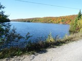
Were there any Algonquin at Lake Saint-François-Xavier at the time of colonization, at the end of the 19th century? The stories of the Montfortian fathers do not seem to us to mention their existence. How could this place have kept its Native American original name if none lived there at the time of colonization? Wouldn’t it have instead been named by newcomers who could also have borrowed it from elsewhere? Thus, a multitude of tiny lots, later so-called orphaned, had been purchased somehow by correspondence or in some sort of lottery, by future Americans owners maybe, or even coming from Michigan, and wherein most had never made such a long trip to settle at the Lake. Closer to home, two American sisters-companies, the Newaygo Forest Products and the Newaygo Timber Co, were in operation in the middle of the 20th century near Hearst, in the Northeast of Ontario; but were they already existing at the beginning of that century and would they have then come around?
Moreover, according to a resident of long date of the hamlet, it was written at the time, on a poster of a logging company: "No further we go"; the words being attributed to the translation of a Native American directive indicated as "Newaygo". But the resemblance here between the Algonquin and English words which could be "No-way-go" leaves us perplexed...
There seems to be no administrative entity or specific boundary to this hamlet; and yet it was an official stop between Montfort and Laurel-Station on the Canadian National Railway line of Montreal - Huberdeau - Lake Rémi.
Upon our arrival in Newaygo, in 2003, we were told that a narrow strip of the Lake shoreline was once reserved to the Indians as passage; but that, following the increase in the level of the water of the Lake, this last was necessarily under water. It seems most likely that the entire region was more or less deserted by the Algonquin since the middle of the 17th century, following the invasion of the Iroquois who had pushed them back into the current Upper Laurentians. Besides, those who could still live in the forest would have more recently been billeted in reserves and more or less assimilated to leave all forest to logging companies. At the beginning of the 19th century yet, there are still some coureurs des bois, like Stephen Jake Beaven in the surroundings of Arundel who lived from hunting and trapping and who was trading with the Indians. Roads, such as the Chemin des Iroquois, lakes and others, reminded the Aboriginal past in the Laurentians.6 But, apart from Newaygo and Lake Tamaracouta, it is difficult to find any Native American name on our map of the Pays-d’en-Haut.7
The Commission de toponymie du Québec recalls that Samuel de Champlain had "identified six groups of Algonquins on his travels, (including): the Weskarinis [Those of the Petite Nation] attending the watersheds of the Red River, of the Lièvre and of the Petite-Nation. The Commission explains that "their toponymy is largely dependent on nomadism... (and) ... includes the set of knowledge on the natural environment, traditional activities (hunting, trapping, gathering), objects of material culture (canoe, toboggan, snowshoes, clothing, embroidery, wickerwork, etc.), and even human beings and the spirits that inhabit their spiritual universe." "It uses the prominent features of hydrography (passage, rapids, confluence, river mouth) and of topography (portage, slope, cliff)". "In short, Algonquin toponymy is a live and pervasive portrait of that people in the West and the South of Quebec." "In Quebec, the Algonquin language... is the most spoken of three indigenous languages, the other being the Iroquoian and Inuit (inuktitut) language." "It is also, among Native American languages, one that is the most represented in the Quebec toponymy. ... (These) languages are made of images... all (belonging) to nature.
"In Quebec, several names are deformations of Amerindian expressions resulting from misinterpretations or uncontrolled deviations. Thus Kazabazua, in the Valley of the Gatineau, is a place name from the Algonquin term Kitché-Badjiwane for something that rushes into the ground. In this case, it is a small river that passes under a stone rise." Tamaracouta (Lake), near Mille-Isles, also seems of Algonquin origin. According to "Histoire du Québec", the name indicates the concentration of tamaracks (larch of America) near a body of water (couta).8
1. Toponymie des Algonquins
2. Newaygo County
3. Michigan State University
4. Courthouses.co, Michigan, Newaygo County
5. The Canadian Encyclopedia
*Exact wording : The hamlet nearby the Lake where the Chief’s boy had a Rainbow Trout’s fish bone in his throat…
Carl Chapdelaine
An MRC’s Fund for Culture and Heritage 2018; call for projects
The MRC des Pays-d’en-Haut is announcing that, for the eleventh year, it has a Fund of $ 30,000 to help cultural and heritage projects. The prefect, Mr. André Genest, recalls that "culture is essential to the development of the territory..."
"Applications will be analyzed in the light of specific award criteria. Thus, projects submitted must conform to one of the six directions of cultural policy of the MRC, testify of significant outreach, contribute to the cultural development of the territory of the MRC des Pays-d’en-Haut, and demonstrate that they are structuring and that they represent a contribution to the cultural vitality." For more details: Fonds-culture-et-patrimoine
The deadline for the filing of an application is February 22, 2018. Financial assistance may not exceed $ 2,000 for the category "cultural project and heritage" and will correspond to a maximum of 50% of the total cost of the project.
The people and groups involved in the field of culture or heritage of Wentworth-Nord could certainly identify and propose projects that meet the criteria of the program. To qualify, they should probably be first at 50% financially supported by the Municipality (If in agreement with the municipal vision...) or any group with the necessary funds.
The issues of regional interest are not lacking. For one, Monfort and its orphanage are loaded with history; local genealogy has to be investigate; as the development of the resort; the juxtaposition of francophone and anglophone cultures. etc.; all themes likely to be the subject of a presentation by an historical and heritage circuit*, the publication of a collection, the presentation of a mural, the creation of a web site, the inventory of headstones, the identification of a style of local architecture for permanent residences and cottages, for landscaping around these or for the whole village, a collection of old stories, or other.
Projects by our artists should not miss more.
*This project has already been presented in last June by la Table de concertation des Arts et de la Culture de Wentworth-Nord and was awarded $ 2,000.
Among the dozens of projects receiving $ 2,000 from the Fund in 2017, let us also mention: 'Memories from here', by the Société d'histoire de Sainte-Marguerite-du-Lac-Masson et d'Estérel, and 'Sculptures collectives végétales', by Échelon des Pays-d'en-Haut.
With the use of Microsoft Translator
Carl Chapdelaine
The sky of the Weskarinis
You may improve satisfaction and slight disappointment at the same time when, new comers to Lake Saint-François-Xavier, you admire this splendidly starry sky that your Montrealers’ eyes don’t often have the opportunity to contemplate. It emerges here as a new part of your environment. Your concern comes about the darkness, which is the best for the observation of the stars, on a moonless night, but which is not yet here total. The lights of Morin-Heights and the glow they leave in the distant sky never seem to turn off. There are also all close, those that several residents of the Lake leave on guard all night.
But if you go to bed with the chickens, you may tend to miss the show; especially when you need to reach the end of a dock at night to enjoy the sky at 360 °. And it doesn’t make it any better if you almost forgot all of your meagre bases in astronomy, so that to find the Great and the Little Bear, or even to identify Venus or the Polar Star, makes you already contended. So when will you relive this fascination that goes back to the night of time and, closer to us, at the time of the Algonquin of the tribe of the Weskarinis, who inhabited this territory before the arrival of Europeans?
We no more need the stars to guide us, and the mysterious side they could represent to ancient peoples has largely been unveiled. We can therefore imagine the importance the night sky could take in the minds of these people. The North or Polar Star is very close to the point of heaven in our hemisphere which is in line with the axis of rotation of the Earth, or north celestial pole. Because of this position, it seems motionless, while the entire sky appears to turn around it. Located on the same axis, the north celestial pole also tells us the Earth's or geographical North Pole. The Polar Star was therefore, at all times, a way of orientation, and we can thus imagine the importance it was taking for nomadic populations.
Many legends are born on the planet from the fabulous interpretation of the night sky. Aboriginal people, who lived in harmony with nature, were well aware of the celestial phenomena and explained them in their own way; they took an important place in their culture. They had already identified constellations, often representing animals, including that of the bear, and myths were associated with them. The position of the stars served as calendar and landmark in the determination of certain seasonal activities. «The Algonquin call the Milky Way the Pathway of the Souls and see it as the trail taken by the dead as they travel to a place that we cannot know. Each star of the Pathway of the Souls is a home fire of the departed, and each night, while they sit around it on their long pilgrimage telling stories, they look down upon us and see our home fires.» Communication between mortals and the spirit world was thus made possible and spiritual leaders knew well its workings.
While sharing the Algonquin mythology, the Weskarinis also had their stories in own on the sky of the Laurentians. Thus, they called the full moon of January the Wolf Moon; because it was the best time to hear them howling. For them, the colors of the setting sun and the position of the head of the bear seemed to indicate the change of seasons. These tribes’ mythology has been largely lost or changed since the presence here of the Algonquin, that could go back to the time of the pyramids, underlines The Ballyhoo.
Regardless of the sensations that invade you contemplating the sky of the Laurentians when all the stars are lighted, the idea that First Nations were able to establish a pan of their culture, while using it as a compass or otherwise, could add to your emotion.
With the use of Microsoft Translator
Carl Chapdelaine
Sources: Main Street, The Ballyhoo, Canada under the stars
The Montfort Pavilion
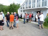
- Multifunctional Center
o The recreational and community Pavilion of Montfort, under the authority of the MRC des Pays-d’en-Haut and managed since May 1st, 2015 by the Coop des 4 Pôles, is one of the access points to the Aerobic Corridor Park, this ' 58 km recreational trail between Morin-Heights and Amherst’. While its lobby is used freely for many years to accommodate residents and visitors, it now offers more services through the year-round presence of one staff.
o The new recreational activities offered by the co-op, with the rental of canoes and kayaks, following the construction of a community dock and gateways, as well as bikes, among other things, helped consolidate the Pavilion in his role. And that's not counting the nearby presence of the important Viking canoë-kayak Club.
o New features are grafted to the multifunctional centre, such as the boats washing station.
o It is simultaneously, as the St. Michel Pavilion or the Laurel Community Centre, a meeting room for the municipality of Wentworth-Nord. The meetings of the City Council are held at this location once all three months, not to mention consultations or presentations, election meetings, or even possible referendums. The MRC is also holding its own monthly meeting of the Council of mayors in the Pavilion, alternately between its 10 constituent municipalities.
o Many events organized by local organizations or other from the Montfort sector, as these famous Pot Luck, and that contribute to the social life of the community, benefit from the presence of the Pavilion.
o The information role here has never ceased to increase. To the availability of maps of the region and multiple information leaflets, was added the free offer of access to the Internet.
o The Center also hosts the Montfort art gallery perched in the rear balcony of the old church. In that small space, the gallery embraces the challenge of bringing together the latest works of local artists, as is the case with the current exhibition, showing their imagination and their often invaluable talent.
o Board paddling, yoga now and other classes provide the Pavilion a development of its activities, while surrounding occasionally turns into kindergarten.
o The old church also remains a place of worship.
- In the correct location
o The Montfort Pavilion serves residents of the main lakes and roads in the northeast area of the municipality.
o It is located before the arrival to the village by the Montfort Road. Visitors to enjoy a canoe trip on Lake St. Francois-Xavier or biking on the Aerobic Corridor, as well as those who are enjoying the slopes of ski and snowshoes trails in winter, so do not have to go through the village when they can enjoy parking their cars around the Pavilion. In this sense promoting recreational tourism is unlikely to increase traffic in the village of Montfort, or even to the dead end of the Newaygo road. One can compare the situation to that of some villages on the nearby East Coast of the United States or at the Mont-Tremblant village, where you leave your car at the entrance; an asset for our Chief planner.
o The opening of the Lake-Thurson Road however, with parking in construction, as already the opening of a parking lot on the Aerobic Corridor, close to the Park of la Plaque tournante, lead the visitor through the village, which is due to increase traffic of cars upon. It should not be so in the future, but any expansion of parking should rather only be allowed in the vicinity of the Pavilion.
- The future of the Montfort Pavilion
o Facing controversy in front of the recreational and touristic promotion pursued by the MRC and the municipality, and now subject to opposite opinions in the adoption of the revised municipal urban Plan and in the election campaign, what will be the evolution of the role and activities of the Pavilion? Where is the expansion plan heard of from Mayor Genest? Murky waters to navigate through for the Board of the Coop des 4 Pôles and its new Executive Director, Ms. Nymark, which should soon hold a consultation session in the same Pavilion.
With the use of Microsoft Translator
Carl Chapdelaine
«La Mémoire» on Wentworth-Nord
A new edition of «La Mémoire» (Été 2017, no. 143), the journal of the Société d’histoire et de généalogie des Pays-d’en-Haut (SHGPH), has just been published. It is largely dedicated to the Municipality's heritage. This initiative was announced at the meeting of this spring, in Laurel, of representatives of the SHGPH with the Wentworth-North’s Heritage Committee and municipal authorities involved in this field.
A first section deals with the birth of the Municipality. A second, under the signature of Mayor Genest, is titled; "The notion of landscape». A third traces the religious heritage, with three churches, reflections of an era and an architectural style. A fourth, entitled 'Characterization of the buildings of interest', aligns photos of old houses, mainly at Montfort, with description of their evolution over the years, if is the case, as well as of their history.
Moreover, one article speaks also of the Janson's family and its origins, as well as of the involvement of Mr. Fernand Janson in research and presentation of the heritage and regional genealogy.
During the initial meeting, an exhibition in Wentworth-North, using the historical material collected at that occasion, had also been promised for this summer. You can probably find this edition at the library of the Municipality, or get it at the office of the SHGPH, in Saint-Sauveur (Chalet Pauline-Vanier). SHGPH
Carl Chapdelaine
Wentworth-Nord's Heritage
On the 20th of March, a meeting of the Société d’histoire et de généalogie des Pays-d’en-Haut (SHGPH)’s Heritage Committee was held at the Municipal library with citizens of the Municipality concerned about the remembrance of this heritage as well as with municipal leaders. The purpose of this meeting was the collection of old photos and evocations of the past to, among other things, produce a next issue of the Société’s publication, La Mémoire, which will be dedicated to the heritage and the collective wealth of Wentworth-North. Among these are of course the creation and development of the village of Montfort along with its agricultural orphanage.
The collection was successful and will also be used to produce an exhibition of the "Treasures of the Municipality", as soon as this summer. The collaboration with the locals has also helped orienting the SHGPH towards the avenues to be given priority. The Société took advantage, in 2016, of financial support from the MRC’s cultural fund program, which allows it to move forward with its project of «enhancement of the Municipality of Wentworth-North’s heritage and landscape».
Through this initiative, a new Wentworth-North’s Heritage Committee could become the preferential interlocutor of the SHGPH and promises of collaboration were exchanged. This new Committee appears on a photo taken on March 20th and published in La Mémoire, hiver 2017, no. 142. There are Mrs. Hélène Fortin and Mrs. Line Chapados, Mr. Yves Léveillé and Mr. Fernand Janson, who has already published the results of his research on the first families of Montfort and other historical facts, as well as Mr. Alex Piché and Mayor André Genest. Now, don't ask what this Heritage Committee can harvest for you, but rather what you can provide them with...
Contact: Mr. Fernand Janson (laurelfj@hotmail.com) Carl Chapdelaine
PS: Maybe a wall panel of historical representation at the entrance of Montfort?
Families of Montfort in 1901, 1911 and 1921
In his newsletter "Le Contact", from the Société d’Histoire et du Patrimoine des Trois Villages, Mr. Fernand Janson has published very instructive data on the first families of Montfort. Mr. Janson indicates that "Out of the nine families established at Notre-Dame de Monfort in 1881, four still live in Montfort in 1901. These families are: Michel Prud'homme/Constantineau, François Cyr, Eustache Leduc and Joseph Charbonneau.» He even follows them in a few generations. We know of many descendants of these families today.
Censuses of Canada1 were an invaluable source of data on the population of the village. They would then, in addition to the fathers’ and mothers’ names as well as of their children, give their place of residence, gender, month, year and place of birth, their origins, their nationality, their religion, their occupation with their revenue, and even if they could read and write. For the censuses of 1901 and 1911, you have access to all these details by internet; but the work is strenuous and some pages seem impossible to find or needing many tries.2 For 1921, Statistics Canada has entrusted to Ancestry.ca to present these digitized data; and it seems to be a good thing when you see the presentation. However, the comparison with the two previous censuses is difficult. It is work for genealogy enthusiasts or those who descend from these families.
Subscribing to Ancestry.ca to access the 1921 census is free; but you still have to give your person's details.3 (On their Homepage, choose rather the "Search" page, then, in their "Special Collections" column: "Census & Voter Lists", and finally "1921 Census of Canada".) In «Browse this Collection», Look for district of Argenteuil, and then sub-district 18 for Montfort or 24 for the orphanage to get out all the pages. When you zoom in, the names, the titles of the columns and the rectangle where the hand is positioned immerge typed.)
Carl Chapdelaine
1. The first Census after Confederation took place in 1871; the second in 1881, etc.
2.Census 1901 (In the 'advanced search', try with Argenteuil --> Wentworth --> Tassé, on the PDF document.) Page 1 : Chales, Charbonneau, Poulin, Gervais, Dionne, Plouffe, Maillé, Lafontaine, Tassé, Paquin, Chisdom, McEvans?, MacGuire?
Page 2 : Tassé, Beauchamp, Desjardins, Forgette, Lacroix, Paradis, Laporte et Corbeil.
Census 1911 (In the 'advanced search', try with Argenteuil --> Wentworth --> Watchorn, on the PDF document.) Page 1 : Constantineau, Corbeil, O’connor, Leduc, Robert, Bélanger, Forget, Millette and Tassé.) Page 2 : Cleary, Neill, Watchorn, Boyd, Hall, Hammond, Letts, Crestwell, Conlin and Brown.)
3. Ancestry.ca
Map of the Laurentians, 1897
The railroad layout
At the height of Lake Chevreuil and Lake Saint-François-Xavier, the layout of the Railroad of colonization of Montfort seems to have been corrected by a simple black line. While it spun almost in a straight line, to the South of the first when arriving from Morin Flat, and North of the second after crossing between these two lakes, with a sure stop at the orphanage, the pencil line makes it now heading towards what we know today as the Aerobic Corridor. It allows it to cross Lake Saint-François-Xavier on the trestle bridge between the Montfort and Newaygo basins. Maybe the track had actually changed its route to better follow the Lake’s borders and serve the current Newaygo area. The Montfort colonization railway company had well refitted the tracks, precisely in 1897, to replace the spacing of 3 feet from the "economic railroad" by the new standard of 4' 8½". On this occasion, the "Montfort junction" had moved to southern suburbs of Saint-Jérôme, where it was able to make the connection with the track of the same spacing of the CPR1.
The map shows that our Railway of colonization line goes up to Arundel, route still used by the Aerobic Corridor.
Missing roads
The map also indicates that a road, for the most part disappeared, was leaving the current Chemin des Montfortains, passing by North of Lake Wheeler, then between Lac-à-la-Croix and Lake Saint-François-Xavier. From this last point, either it went directly toward Grand Lac Noir (following the limits between lots IX and X). It bypassed Lake Noir by the North before pointing down in joining Laurel, with a section apparently not existing anymore, while a branch line reached the passage between the Sixteen Islands Lake and Lake Laurel. Either it joined, by perpendicular bifurcation, a road west of the Newaygo basin, in direction of Laurel-Station and which last section seems to be a current road reaching this last place.
The Rivière à Simon
The route of the Rivière à Simon is not the one found on today's maps. It rather corresponds to the Jackson Stream, with its source at Lake Anne. This stream heads towards Lake Echo before joining the current Rivière à Simon, through Lakes Daïnava and Seale2. According to the map of 1897, the Jackson Stream had to be the first section of what is then referred to as the Rivière à Simon. Would the cartographer have been wrong? The choice of the right tributaries to determine the main course of a river is not always obvious. Or would rather, the building, in 1900, of the great dam at the foot of Lake Saint-François-Xavier, tributary of the current Rivière à Simon, have changed its flow making it the main watercourse, relegating the Jackson Stream to the rank of simple tributary?
Principal Lakes North of Montreal, 1897 (.pdf)
The Irish in Wentworth-Nord
Historians relate that the first colonizing families being established in the 1850s, in the Northwest corner of the Township of Wentworth, which became Laurel, came from Ireland. They called their place 'New Ireland'. A century later, the entire sector in an L shape, to the West and North of the Township, from St. Michael to Montfort, became Wentworth-North.
The great famine of 1847 in Ireland had occasioned this exceptional flow of Irish immigrants in Quebec. But Irish blood also flows through the veins of many inhabitants and cottagers of the municipality, who do not necessarily descend from these pioneers, as the undersigned...
Carl Chapdelaine
Colonization roads of Montfort
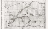
[Click to zoom the image] In his Société d’Histoire et du Patrimoine des Trois Villages "Le Contact" newsletter, summer 2008, Mr. Fernand Janson publishes an old subdivision plan around Lake Saint-François-Xavier.
You can see on the attached topographic map of today approximate reproduction of two existing roads at the time, crossing in long rows 10 and 11. Originally forest access roads, explains Mr. Janson, row 10's one allowed to go to the agricultural Orphanage of Notre-Dame de Montfort. It could thus be reached from Saint-Jérôme, passing by Mille-Îles. It was "before the construction of the great road of colonization, the future Road 364 West. It was also used to go to Laurel, passing West of Lakes Noir and Argenté.'' This road became the Jackson and des Montfortains Roads; while its western branch is now missing.
Concerning the road going through row 11, it headed East, towards Saint-Sauveur and, to the West, will become route Principale towards Laurel.
Carl Chapdelaine
Huberdeau: the legacy of Montfort
Meanwhile, this successful project of colonization would also have generated the creation of an agricultural establishment on the Red River, in the Arundel Township which, established on more fertile grounds, could later accommodate part of the young people trained at the orphanage, thirty miles away from it.


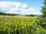
You wiil soon be able to reach Arundel and Huberdeau by the Aerobic Corridor.

Little Mary's Hostel
At the end of 19th century, Montfort had only 30 houses which were well aligned with the Church, the presbytery, the hotel, the general store, and, farther away, the orphanage. There was also, a way apart, a nice, big white house with columns at the entrance. This would become the hostel of Little Mary.
How the redhead of sixteen years, could have left her home in Scotland and ended up in this new village of the Laurentians? What role did Mr. Brown, an importer of fine fabrics, have to play in this? Mary’s wedding photo, now known as Mme Paradis, which shone on the sideboard of the hostel, would have much to tell about this story. Fortunately, Laurette Paquin, the granddaughter of this Scottish woman, Mary, made her childhood memories come back to life through this story.
Mary was going to transform her large house into a pension-hostel for workers on weekly agreement basis. A description of this environment and the life at the Inn brings us back a century. The hot bath was taken on Saturday afternoon, in in a corner of the kitchen encircled by thick curtains. The men were okay with this ritual.
Then Mary lost her husband, a victim of a hunting accident. The body would be exposed in the house, as was the ritual of the time. It would be laid out on boards dedicated for this purpose and covered with a sheet. Mary, having learned to rely only on herself, continued to run the Inn until the day when another adverse event made her fate fall over again. Mary would then leave Montfort and ... move with her Inn!
You will discover this story, true or not, of Little Mary and her Inn in our spring 2014 Newsletter.
Carl Chapdelaine
up
First steam train
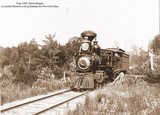
The Montfort Colonization Railway first steam train would have arrived at this village in 1894; the route was starting at the "Montfort Junction", then north of Shawbridge. It was a narrow-gauge (3 ft) railway known as «chemin de fer économique». The attached photo, dated 1895, should reflect this situation.
The two locomotives dedicated for this service, as well as cars and other specific equipment, possibly came from the Abitibi-Témiscamingue Region where this type of narrow gauge railway had just been replaced by a standard gauge one.
But as soon as the 1897, the Montfort Colonization Railway Company, which would change its name for the Montfort & Gatineau Colonization Railway Company, hoping to reach the latter region via Huberdeau, made the same move and converted the tracks to conform to the standard in use in the East of the country, with a gauge of 4 feet 8 inches and half.
Following this standardization, the Montfort junction moved to southern suburbs of Saint-Jérôme where the railway was able to make the direct connection with the CPR tracks.
Source: The Montfort Story, O.S.A. Lavallée, Canadian Rail, number 135.
http://www.exporail.org/can_rail/Canadian%20Rail_no135_1962.pdf.
More from Canadian Rail: Montréal - Montfort - Huberdeau:http://www.exporail.org/can_rail/Canadian%20Rail_no284_1975.pdf.
The last train
Route 34 : Frenieres - Lac Remi; see in: Quebec& Labrador Railways - SL 150 ; Passenger stations & stops; Canadian National Rly (1-53). route 34. http://www.railwaystationlists.co.uk/pdfcanada/quebecandlabradorrlys.pdf (p. 8)
Abandonment of the route: «This arrangement would be similar to that covering the abandonment two years ago of part of the National's picturesque Montfort Subdivision in Quebec. The adjacent photograph (p.273: close to end of document) shows a passenger train following the shores of Lac St. Francois Xavier between the villages of Montfort and Newaygo.»
http://www.exporail.org/can_rail/Canadian%20Rail_no160_1964.pdf Photo - P.Ganley
Last train (diesel) to Montfort. see picture of the steam train and the account of the last voyage p. 91: 'Farewell ': http://www.exporail.org/can_rail/Canadian%20Rail_no134_1962.pdf
Montfort Leduc
Memories I have collected from Mr. Jean-Louis Levasseur, orphan at the orphanage in the late 40’s and son in law of «Montfort Leduc», first baby boy to be baptized at the village (1883). In «Lake St. François-Xavier Newsletter», Fall 2010 (in French only; translator welcomed).
«The steam train arrived on Fridays. Among luggage, there were reels of film; the broadcasting took place on Fridays evenings for the public of the village and on Saturdays evenings for the orphans. It had repeat broadcast on Sundays when the weather was bad. The train was leaving on Mondays. There was also theatre and concerts. The Alouette quartet3 was welcomed, as was the young prodigy Gérard Barbeau, boy treble famous here and abroad.» Gérard Barbeau sings Tristesse from Chopin (Etude Op 10 No.3); YouTube
up
The origins of Montfort
In the winter 1880-1881, a group of citizens from Montreal expressed their intention to buy some lots somewhere in the Northern Townships. Their project followed the patriotic movement of colonization earlier associated to the famous ‘’Curé Labelle’’ (François-Xavier-Antoine Labelle), St. Jérôme parish priest, and combined the intention of creating an orphanage there.
So, three scouts ventured in the forests of these townships, in search of a favourable place. They arrived in the north portion of Wentworth’s Township, in dense forest, at the foot of the lake dedicated to the apostle of the Indies and Japan (Saint François-Xavier). There, close to where would later be the mill and the orphanage, they estimated to have found a place sufficiently close to Montreal, and especially to Saint-Jérôme. The ground, though rocky, appeared acceptable to them and the forest abounded in trees of good quality, an already precious resource at the time.
In Montreal, in the two months that followed and using an approximate map of the territory, about sixty brave men bought the first lots from the government, lots that the majority of the persons had never yet seen. That would be sufficient to plan for the making, one day, of a parish “which they initially agreed to name «Notre-Dame of the Lakes» considering the many lakes in the vicinity”.
The pioneers then started clearing the land; masons and carpenters bustle about; mills, sawmills and the right wing of the orphanage took shape. It was already the fall of 1881 and, needing a saw and shingles mill, etc, Mr. Joseph Bureau discovered a water concentration point. Dwellings are built there one after the other to shelter these new parishioners.
On August 24, 1883, accompanying a group of orphans, two fathers and six brothers of ‘’La Compagnie de Marie’’ (Monfortains) arrived from France to head the new establishment and to take charge of the agricultural orphanage. It is in honour of the founder of their community that the parish would finally take the name of ‘’Notre-Dame de Montfort’’.
One decade later, the railway, having already reached Saint-Sauveur, would also take the direction of this new village. Two hours and a half would soon be enough to reach the place. Meanwhile, this successful project of colonization would also have generated the creation of an agricultural establishment on the Red River, in the Arundel Township which, established on more fertile grounds, could later accommodate part of the young people trained at the orphanage, thirty miles away from it.
Sources: The major content of this article mainly comes from: «Orphelinats Agricoles de Notre-Dame de Montfort», published in Montreal, in 1883 and can be viewed at the following link:
http://www.archive.org/details/cihm_02187
up
Municipality of Wentworth-Nord
Montfort is one of the three villages of Wentworth-Nord and is located to the northeast of the municipality.