

 English
  Français
Roads and access roads
- Hunter Extension Flow of June 23, 2022
- Hunter, the extension of the problem!
- The Hunter monster
- «Hunter's slide»
- The "Hunter flow"
- After the flow, video
- Hunter's corniche
- Street vs environment
- Extension Hunter St.
- The Lake à la Croix road
- The Mount "Street" (essay)
- The Thurston shortcut
- Thurson Road: call to tender
- Thurson Road?
- Lac-à-la-Croix : path to road?
- Nord-Wentwortois, access road, etc.
Hunter Extension Flow of June 23, 2022
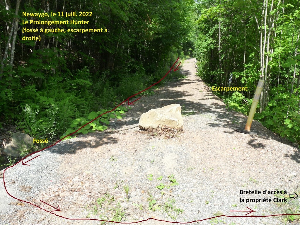
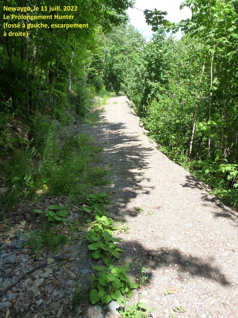
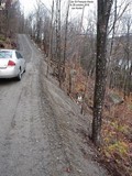
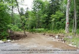
The Hunter Street Extension on the side of Napoleon's Cap is now just a long, steep, abandoned path. But this inconceivable construction, which collects runoff from a hillside and the dirt it carries, is still busy destroying its surroundings.
The spring of 2022 had not brought disaster; but the storm of June 23, which was not the most impressive and yet more devastating than the previous ones, would remind the downstream residents of this Extension that the threat had not been averted. A mini-torrent once again took the ditch of this sloping road and once more, at its foot, deeply gullied the access ramp to the Clark-Dunford estate. Then it made its way through the beautiful gardens of which the mistress of the house was proud. On the call of our couple, Wentworth-Nord quickly dispatched the necessary crew to repair the damage left on the ramp by the flow.
The vidéo shot by Mrs. Eleanor Dunford and posted on Facebook shows how devastating this recurring event always is. Not to mention the fact that some of the material carried by this gully ends up in Lake St. Francois-Xavier, over a ton of debris for sure.
And not only did the flow carry its share of sediment, but it swept into the lake some of what the three previous flows had left on the shoreline. It is well foreseen that, in a still distant geological age and responding to the phenomenon of flattening of the earth's surface, the whole hill will contribute to fill the lake, but nobody here wants to see this phenomenon accelerate in front of the current dead end...
The steps taken with the municipality to definitively solve the problem do not seem to have borne fruit yet, and nothing concrete has transpired about the solution envisaged. Does the fact that legal recourse, probably on both sides, has been initiated explain the apparent inaction on the ground?
The only tangible solution remains that of restoring the morphology of the site to what it was before tractors and plows destroyed the stability that nature had established there. Over the years, storms and runoff would naturally restore the balance broken by the construction of this road if nothing was done before. But the residents and the lake would pay a high price.
Furthermore, the Hunter Extension must have weakened the terrain it follows, which itself threatens to break up and cause an avalanche of rocks and earth perpendicular to the escarpment. If such an event were to occur, it could have a major impact on downstream properties and pose a serious threat to the safety of their inhabitants. In such a case, the sediment supply to the lake would also be major and instantaneous.
It should be noted that the calls for help and action, both to the municipality and to the Lake Association, reiterated by David Clark, a victim of this latest flow and concerned about its environmental impact on the lake, have led to sulphurous exchanges of letters between our resident and the ALSFX. While he accuses the association of not having moved, in the face of a recurring event and second in importance after the Thurston Lake outflow as a threat to the lake environment, he points out, Mr. Raymond Noël, President of the Association and Mr. Stephen Yeats, of the Executive, accuse Mr. Clark, in return, of lacking judgment, of threatening and seeking to intimidate his neighbors, friends and family, for frivolous and vexatious motives towards the organization. Mr. Noël and Mr. Yeats, whose comments about Mr. Clark are considered by many to be slanderous and insulting, demand an apology for Mr. Clark's tone toward them and threaten to publish his e-mail for their members and neighbors to judge. Mr. Clark, however, sees no justification for this.
Based solely on our knowledge of the exchanges we have been informed of, and with all reservations; by Carl Chapdelaine,
Translated with www.DeepL.com/Translator (free version) & Linguee
Hunter, the extension of the problem!
Let's recall that the extension of Hunter Street on the side of Napoléon’s Cap, on a steep slope ending on the shore of Lake Saint-François-Xavier, had as its primary purpose to allow the four secondary residences located on this shore to be equipped with septic tanks in order to comply with the regulations.
At the municipal meeting of July 18, 2018, Mr. André Soucy, former District Councillor, specifically asked if the Municipality would proceed with the required piece of street, on the Hunter and Sunny-Side Roads side, to allow for the upgrading of the installations and the disposal of wastewater from the affected properties. Councillor D. Zgodzinski replied that the cost was disproportionate and that they would look at alternatives. One property owner had already installed a composting toilet, he added.
In the summer of 2019, three of the affected property owners applied to the municipality for a permit to extend Hunter Road to a ledge to be developed as a parking and U-turn point for cars and service vehicles. The fourth property owner refused to join the operation.
On August 15, 2019, having learned of such a project from surveyors walking the trail that would be transformed into a carriage road, Mr. David Clark, wrote to the Municipality, with a copy to the Lake Association, to ask if such a project was planned or not. If so, he wanted to be assured, with a copy of the appropriate studies carried out, that the work would be in conformity with the recommendations of the experts and that the environment would not be threatened. He pointed out the risks, for him obvious, of destabilization of the hillside posed by the degree of the slope and foreshadowed the outcome of a strong sedimentation in the lake. Mr. Clark also explained the threat to the riparian owners of opening this road on such a steep slope. He described the consequences that would indeed result.
Councillor Zgodzinski assured him that, although a project might have been under consideration, it was certainly not on the Municipality's agenda. A few days later, however, Mr. Clark learned that the permits had been issued by the Municipality for the realization of such a project.
On August 29, Mayor Ghali himself responded to the concerns of Mr. Clark and his neighbors. He brushed aside the objections and fears expressed, stating that the project they would authorize would be for the greater good of all. He said that no environmental study was required for such a relatively small project.
He had visited the site with the inspectors and the engineer, and saw no problem with the discharge into the lake from a development that would be more than 150 feet from the nearest shoreline. If special mitigation measures were required to prevent unlikely environmental impacts, the municipality would discuss them with the contractor.
(Didn't we just apply a very costly remedy, subject to regular monitoring, following the monumental error of the creation of the Grande Côte, with the burial of two sediment pits between the foot of this hill and the Montfort Bridge, coupled with the reorganization of the pavement and the ditches? Fortunately, this solution was paid for by the Ministry of Transport, but it did not solve the problem of the discharge of road salts and other contaminants into the lake. Should we have made a similar mistake again?) The mayor also assured that future maintenance costs, both summer and winter, would be upon the shoulders of the owners responsible for the extension.
So the road was built in September 2019, mostly on a strip of municipal land, but not only. The problems announced by Mr. Clark quickly became a reality on October 31, when the Halloween Storm hit part of Quebec (see our article "The Hunter Flow"and following.).
Since no drainage system had been provided for during the construction, all the water coming down the slope of the Chapeau de Napoléon and meeting the new road, ended up crossing the Bonnin's property before reaching the Lake; with the disastrous environmental consequences foreseen from the start by Mr. Clark. Today, about 30 centimeters of silt remains in the lake.
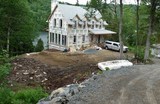
At the beginning of November, once the work had been completed and the first damage noted, Mr. Bonnin and the Valiquette/Fortin family had received a request from the Municipality to authorize the construction of a sedimentation basin on their property bordering the lake. Wishing to know more about the conditions of this development and its consequences on the value of their property, and in the absence of satisfactory answers to their questions, they did not give this authorization.
The Municipality had to send crews to try to repair the damage to Mr. Clark's property caused by the flooding of the shoreline. Mr. Clark and his wife, Mrs. Eleanor Dunford, whose garden had been patiently developed over the years, would spend countless days restoring it to its former glory.
On June 5, 2020, after several exchanges with the Municipality during the winter of 2019-20, but, despite the request, without any meeting or proposal to implement a solution before the arrival of spring, Mrs. Claire Valiquette, on behalf of the aggrieved riparian owners, Clark/Dunford, Fortin/Valiquette and Bonnin, presented the Municipality with a document summarizing their point of view. She noted that attempts to rehabilitate and protect the affected properties, the improvements made to the extension itself, such as the placement of gravel mounds on its edge or the rising and sloping of its surface, which have narrowed its width and made it impassable to traffic, do not offer any permanent solution to the problem. A second consultant, Mr. Viger, was commissioned to work on the project, but his report or any proposed solution was not made known to the stakeholders.
The group saw three options:
1. A complete redesign of the road that would solve the problems and allow, as planned, for the eventual emptying of septic tanks; but how and at what cost?
2. A status quo option, with improvements that would reduce the environmental impacts and their maintenance; (essentially a poultice on a wooden leg...).
3. Finally, the option he advocates: to go back and restore the route to its original state.
He asked for a meeting with the authorities to take stock.
Mayor Ghali responded by indicating, at the outset and to the astonishment of the group, that the file had been referred to him after the fact, since the application for a permit was the responsibility of the administration... He had visited the site, noted the damage and expressed his regret. He plans a meeting to find a satisfactory solution together.
The meeting is held. The mayor rejects any idea of abandoning the road. He then indicated that the group's proposal to build a parking lot at the foot of the extension would be examined. Such a parking lot would make it possible to reach the landlocked properties using a much less steep terrain and with only a little more walking distance.
But nothing will happen during that summer, nor during the winter of 2020-21; except for additional damage and some work on the affected properties... Then comes an email from Mr. Zgodzinski who says himself no longer receives all the Information from the administration or the mayor in relation to the file (as on many others today, one can assume).
The Councillor will however manage to send the group a copy of a report from Mr. Viger as well as Mr. Hébert's plan with the construction of two retention/sedimentation basins. The required ditch redesign alone would cost $129,000 (excluding taxes and contingencies). Mr. Zgodzinski is also holding separate meetings with the two affected riparian groups. To the dismay of the Bonnin, Clark/Dunford, Fortin/Valiquette group, the Councillor ended up not answering any of the questions asked (parking, feasibility of septic systems, layout of the extension, who would get the bill, etc.). He will simply indicate that they are all to be considered at a later date...
At the Council meeting of August 20, 2021, he will invoke the fact that the litigation is now in the hands of the lawyers and will regretfully no longer be able to discuss it. At that same meeting, the mayor will offer to meet with the group, take the matter into his own hands and propose a solution, on the condition that the councillor not be present.
The Lake Association advised the municipality, in a letter to Mayor Ghali, that they had tested the water along the lakefront in the fall, where much of the sediment-laden effluent from the Hunter Road extension had been discharged. Samples taken after a normal rainfall on its behalf by Mr. David Clark showed phosphorus levels ten times higher than elsewhere in the water body. Nitrogen levels were even worse. It wondered what could happen in the event of a heavy rain or spring melt and invited the municipality to take appropriate corrective measures.
Engineer André Philippe Hébert, currently Acting Director of the Roads and Recreation Department, proposed a solution based on his knowledge: two huge basins should be built on half of Mr. Bonnin's land below Hunter Road to collect the sediment-laden water that was being discharged into them from the ditch. (Would sediment pits, buried under the same land, be an alternative?) One, two, three hundred thousand dollars should be enough to do the job... Not to mention the need to collect the contents of these ponds (or pits) ad vitam aeternam. And from which grants would the funds come?
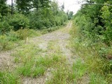
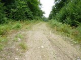
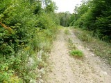
In the meantime, this section of Hunter Street is closed to all traffic. Nature is already visibly trying to reclaim it. Given the ...speed of the file's progress, it may be nature that, over time, will impose the solution already proposed by Mr. Clark to return to the pathway that existed there before!
On the other hand, the property owners who commissioned the project and spent a small fortune to meet the Municipality's requirements, and who have now served it with a formal notice indicating that they care about this road, are making additional, sometimes costly, improvements to access their property from the Hunter Extension. Two have chosen to create a pathway from the foot of the road down to their shoreline properties.
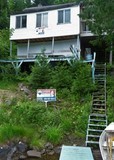
The third chose to build a massive staircase down the steep slope at his cottage from Hunter Extension; each step made of plastic mesh. A construction whose price one dares not estimate and which could present a serious danger of accident when used in wet weather or in winter.
But the more money is invested in this irretrievable project, the less likely it is that the slope will be returned to its original state and that the problem, which has been created here from scratch with unspeakable environmental repercussions, will be resolved.
This return to the original state, the loss of the money invested on all sides, would obviously not solve the problem of bringing the wastewater discharge facilities into compliance. Mr. Clark was banking on emptying any septic tanks by tanker, as was done in the West Basin (Newaygo) of the Lake. However, a ramp would have to be built to allow access to the eastern (Montfort) portion of the Lake. The authorization of composting toilets or other derogation to the current regulations would, in our opinion, also deserve to be considered.
As for the fourth owner, the one who refused to get involved in this adventure, the Municipality would have given him special treatment, ...the prohibition to use his cottage!
By Carl Chapdelaine
The Hunter monster
How do we deal with the huge problem created by this insane plan to extend Hunter Street on the side of one of the highest peaks in the region? All this to allow the installation and emptying of three or four septic tanks for the same number of cottages, or a common one, rather than just an exemption and alternative solutions, such as compost toilets. And we don't see how we could, in any case, pump the contents of these eventual tanks to Hunter's "Corniche", mostly dug out of the rock. The difference in height and slope here is so impressive that it does indeed pose an additional challenge to the purpose of this project.
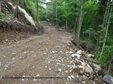
The hasty digging, still in the rock, of the ditch that now borders all this extension upstream has only made the problem worse. The water from the runoff from an entire section of the hill, during storms or thaw, furiously travels through this channel with all the sediment it carries. Supposed to spread out down the long slope on the flatter parts of the shoreline, while its sediment load is held back by an (illusory) barrier, the water has instead extended the ditch to the lake. And the most serious storms that could be seen here would not yet have occurred.
Some of this frightening amount of sediment has accumulated along the shoreline, permanently changing its state. The build-up is clearly visible to anyone who wants to take a look at it and who would know its previous state. We had an event here that reminds us a bit of the demolition of the Thurston Lake dam that led to the class action that we know of, with irremediable environmental consequences and loss for the affected shoreline residents. Worse, a recurring situation was created, as during the construction of the Grande Côte on the Principale. Sand ripped from the Napoléon’s Cap, or from the gullying of the land below, will continue to fill this shallow area of the Lake, as the Big Hill has done for decades. Over time, the current will spread it out far beyond what can be seen today. And even if some of the sediment were to be retained, as with the trench dug at the foot of the Big Hill, the phosphorus and other chemical elements contained in the water will inevitably end up in the lake; as is always the case in the channel spanned by the Montfort Bridge, minus the salt.
The ditch along the extension is not deep enough to channel all the water that can flow over it during storms. In any case, since there is a mid-slope fold in the ditch where water builds up, it is already essential to over-excavate the ditch. It would probably take a few hundred thousand dollars to complete this work in the rock all the way down. And that would only increase the problem of sediment supply to the Lake.
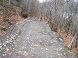
This dirt road consists of a flatbed made up mostly of material torn from the hill. It is gullied with every major runoff, and the accumulation of water mentioned above could undermine it and wash much of it away, sending it down this steepest slope. One need only look at what happened in this regard (rocks falling down the slope) during the construction of this extension.
Who will find a solution other than to deconstruct this road, restore the entire landscape that existed there and allow the runoff from the side of the mountain to spread over the entire forested slope, as nature intended? To spend more money to continue the project, without being able to stop the long-term negative impact on the environment, or to use common sense and go backwards? Where are the protectors of the Lake who will demand that the problem be solved and that such nonsense be stopped in the name of the environment?
Note: Thank you to the shoreline residents who have provided us with observations and explanations on the situation, and who take up this cause, like many others, for the protection of Lake Saint-François-Xavier.
Translated with www.DeepL.com/Translator (free version) & Linguee.
By Carl Chapdelaine
«Hunter's slide»

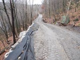
Digging a deep ditch and constructing an embankment along the upstream side of the street extension was the remedy found to channel the flow of water from an entire stretch of hill beyond the intersection on the original Hunter Street section used by that flow on the 2019 "Halloween Storm". Arriving further down in a flat area, the ditch now leads to a culvert that allows the flow to pass under the street and spread out in a wasteland before reaching Lake St. Francois-Xavier.
The enrockment of part of this ditch and the wasteland must slow the speed of the water and the transport of sediment torn from the mountain. The day after the snow melted, however, we can see the traces of a spring runoff left on this wasteland. Furthermore, the condition of the ditch may not be definitive; disturbing bales of hay, rock to be blasted, etc., suggest the need for a finishing touch, and do not give this street extension a very good appearance. This also points to the need for ongoing maintenance of this section and a more appropriate development of the wasteland into a sedimentation basin that should protect the lake from sediment.
Translated with www.DeepL.com/Translator (free version) & Linguee
The "Hunter flow"

On October 10, we saw a tractor completing the earthworks on the extension of Hunter Street, at the top of a rather impressive hill attached to the side of Napoleon's Cap. This enterprise of the municipal authorities proceeded in spite of the opposition of owners to whom, we can understand, the latter imposed a servitude by encroaching on their property. The said owners also warned that the creation of this steep road, with deforestation and exposure of the soil, would lead to erosion whose discharges would reach Lake Saint-François-Xavier below. They could not imagine how right they were.
October 31 was unleashed the Halloween Storm on part of Quebec; the Laurentians were not spared. The runoff on the slope upstream of this road could only pour into it. An impressive stream of water, probably mixed with mud, gravel and other debris, followed it, and then turned into the waterfront properties access ramp from the foot of the extension of Hunter Street. It left behind gullies before flooding the flat land along the shore and reaching the Lake. The Municipality will quickly dispatch the equipment and labor needed to restore the ravaged road.
The elevation profile of this extension of Hunter Street also suggests that, at its summit, overflows of runoff had to cross the downstream side of this street, with its ledge, to descend below the escarpment it borrows. Here, fortunately, no access ramp to the riverside cottages has yet been built and the ground has remained wooded, as it should always remain on such a slope.
Is this sad fact only an episode of the consequences of this hazardous construction? What will happen in Spring on this slope when thunderstorms add to the melting snow? Should not we be witnessing an even more devastating flow? How can we solve the problem in the longer term? Will it be necessary to install a sediment tank, as at the foot of the hill on Principale; since we have obviously not learned the lessons of this monumental mistake that, over the years, almost filled the channel under the bridge of Montfort and the entire section of the Lake downstream? Or create a large retention pond on private property, if there is some flat land at the foot of the Hunter Extension? Should we not rather let this side of the mountain get back its forest cover and forget a crazy project, made to counter a hypothetical pollution by wastewater systems not compliant with Regulation Q-2, r. 22 of four seasonal riverside cottages?
Wentworth-Nord has since hired an engineer to find a solution to the erosion problem caused by this road. And who will pay to fix all this; assuming it is possible? The owners of the cottages to be served were to be charged the cost of its construction; then it would be totally supported by the Municipality, assured Mayor Ghali.
Would the extension of Sunny Side Road to the same place, rather than Hunter Street, have been better? The flow could then have been channeled to the ditch along this street to the sediment tank at the foot of the Grande Côte. At the June 10, 2013 Municipal Council meeting, Mayor A. Genest indicated that the mandate to specify the terms of connection to the "Sunny Side Area" public road was added to the feasibility study on the upgrade of the septic facilities ordered from Laurentides Experts Conseils. That was obviously in connection with the four cottages mentioned above and included in this sector.
Poor Lake; the construction of the Grande Côte, the Thurston Lake flow, the Hunter flow and what after? Since the rise of its water level, more than a century ago, man will not stop accelerating its filling. The Goethe / Dukas Sorcerer's Apprentice, with his buckets of water, would not have done better.
Note: A video, shot on November 1st and posted on Facebook, describes the scene on the Hunter Street Extension this fall: See below.
With Google Translate and Linguee.
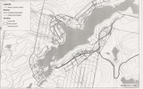
Ps. The Google Earth graphics are for illustrative purposes only.
By Carl Chapdelaine
After the flow, video
Hunter's corniche

Street vs environment
A question about the extension of Hunter Street, attached to Napoleon's Cap, was addressed to the Mayor at the regular meeting of the Municipal Council on October 18th. The resident of Lake Saint-François-Xavier wanted to have explanations about this Municipality undertaking.
Mayor Ghali said at once that this street was a municipal road. As we had deduced, it was a question of joining three or four lakeside seasonal cottages to allow the installation and the service of septic tanks. The mayor added that this would eliminate a source of pollution for the Lake. (Due to the lack of recording of the debates, we could not note the exact terms used by the mayor). The Mayor stressed that this construction was the responsibility of the residents concerned, we understood.
On the occasion of the end of this council, probably the longest of the year to date, time probably did not allowed more elaboration; but our thirst for details remains unfulfilled.
Are these seasonal cottages currently equipped with composting toilets; with limited production of greywater? The arrival of a road will eventually allow an establishment year-round and more than doubled attendance by the owners concerned, their visit and services by road made accessible. If composting toilets were replaced by ordinary toilets, the production of wastewater, then only household, would be increased tenfold and completely converted into that of black water. In any case, the concentrate of these new septic tanks will have to be recovered and it will borrow the Hunter St. to be evacuated; service that the Municipality intends to support.
Can we be shown, using the lake pollution tests that had to be done at the foot of these residences to justify the mayor's assertions, that there was a real need to build a road on the side of the mountain and to maintain it, to fix the problem? Should it not be enough here to invoke the respect of the current regulation on the discharge of wastewater from isolated dwellings and for which we are still waiting for the changes announced under the former government and which, hopefully, will favor the most ecological avenues?
What will be the overall result of this construction, which, with the addition of driveways and parking lots at the edge of the Lake, may produce an additional load of sediment, or even added ice melter for winter maintenance of the latter? Will it really be more positive for the environment of the Lake than the adventure of the Lac-Thurson Road? In the long run, it's unlikely; since sedimentation could be more damaging to a lake's life than a point load of potentially contaminated wastewater.
By the way, should the public authorities in the country not find more valid justifications for the construction of roads, pipelines or other than the preservation of the environment? Should we not give the citizen information scrupulously based on proven facts and that does not risk misleading?
With Google Translate and Linguee
By Carl Chapdelaine
Extension Hunter St.
The Municipality is obviously moving ahead with a project under the old administration, do we understand; that is, the extension of Hunter Street to serve four houses without road access.
It was then a question of allowing the installation and the service of septic tanks for these dwellings.* The extension of this street seems also to borrow certain parcels of private property; without their owner having given permission.
However, we do not know the detail or the last justifications of this project; nor if the cost of construction will be passed on to the owners served. Could the extension of Hunter Street in the direction of Sunny Side Street eventually reach the latter or will both roads remain dead ends?
*Can we speak of a project that is just as environmental ... as could be the Lac-Thurson Road? The latter was, in fact, mainly motivated by the need for the owners of fifteen or so seasonal residences to comply with the regulations on sewage disposal. It also had to divert road access from some properties oriented towards the Aerobic Corridor.
This extension of Hunter Street is on a sheep mountainside and some fear that, although the project is likely to be subject to established standards, it will result in increased sediment input into the Lake below. Hunter Street and the extension undertaken, however, do not seem to conform to the road standard, as is the Chemin du Lac-Thurson. But the undersigned does not know to what standards the construction of roads or streets must conform today; or if there may be an exception to the rule, depending on the impact on the environment or otherwise to be considered.
Without prejudice; by Carl Chapdelaine
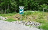
The Lake à la Croix road
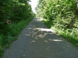
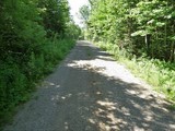
Yesterday's path has become a vehicular road; but for what purpose? Is it to allow the subdivision of new lands around this beautiful wild lake or just to give more direct access to the Orphans’ Trail, as described in the promotion of Lac St-Victor Estates?
Lake à la Croix is at the absolute head of a sub-watershed; it empties into Lake St. Francois-Xavier, from which it is separated by an elongated swamp. In theory, it should not be connected to Lake St. Victor, two steps away; just across the watershed between the Rouge catchment area and the Rivière-du-Nord’s one.
Phase 5 of the development of Lac St-Victor Estates mainly concerns the perimeter of Lake à la Croix and the project is ongoing; but no construction has yet appeared. The Lake seems shallow, according to the appearance of lily pads on part of its surface. http://www.lacstvictor.com/en/available-lots/
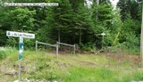
The Lac à la Croix road leads to the Berges-du-Nord road on the north side of Lake Saint Victor, with its prestigious properties. A padlocked barrier prevents entry to vehicles; while, at this time of the season, an immense well trained army of deer flies has already spotted you... The new road is not the only way to access the edge of the lake; some access ramps from chemin des Berges-du-Nord remained at the clearing stage. Of course, no one could stop you from getting parachuted in the Lake, in Lake Saint-Victor or any other one in Quebec, since they belong to all.
It is obvious that a short extension of such a road to the Lake Saint-François-Xavier Newaygo Basin could serve a section of Mount Street to be built. It would open up some of the fifteen or so cottages without road access in the area. However, this new narrow road does not meet the construction standards required for a public road like the Lake-Thurson road. It is also probably not in the views of Lac St-Victor Estates to allow this junction.
By Carl Chapdelaine
Lac-À-La-Croix : Path To Road?
The Mount "Street" (essay)


Prior to the construction of the Lac-Thurson Road, the actual Mount Street, named after an owner who lives there, was only a few hundred meters collected to Rue du Chemin-de-fer, east of the Newaygo bridge. The approximately 50 no-road access cottages bordering more than half of the Newaygo Basin to the south and west were assigned an address on the virtual extension of Mount Street. Several kilometers of this "street" thus encircled this portion of the Lake, according to the chalets which had been built there; or perhaps following the public corridors, parallel to the shore on the cadastre, and located 200 feet from the latter.
The Lac-Thurson road opens perpendicularly onto a stretch along the shore, built as part of the same project and became a real section of Mount Street. However, this stretch, which would eventually join the beginning of the existing street, to the East, does not go as far as estimated in this direction. It should not have allowed access to the Aerobic Corridor; but rather divert traffic that already borrowed it to the new road. Was this reduction in the road's length the result of pressures from recalcitrant residents in front of the attached bill that would be passed on them, or due to exceeding the original budget?
It has now been nearly two years since the vacationers and a few concerned permanent residents of Lake Saint-François-Xavier began using the new Lac-Thurson Road; it was even before its inauguration. What has been the impact on these residents of the opening up of this sector?
We have not yet been able to investigate those who have seasonal cottages; normally closed during the cold season. Those who already had year-round living properties, with a compliant septic installation, may not have known too many major changes. The main one is access by the new road rather than by water or some hazardous path. Today, the proliferation of driveways or private access ramps to this new section of Mount Street is a good example of the transformation. It is also certain that, for their owners, deliveries of materials and others no longer suffer from the previous puzzle.
For all residents of the opened up area, the road has also, for example, brought visitors, not always wanted. Some ask if any property would be for sale on the Lake shore; but can not one fear that it is sometimes to simmer some burglary? When there was no road, as is always the case with the two dozen seasonal residents at the head of the Lake and not reached by it, we never saw a stranger prowling around; but neighbors, relatives and friends.
If the road opened up the area for humans, we knew it would not be the case for wildlife. This rather impressive road was going to enclose a whole triangle of forest, already delimited on two sides by the road of the Montfortains and the Lake; or at least create a sometimes impassable barrier for terrestrial animals. What happens is sometimes even more disturbing. It seems that several species are disoriented; perhaps by the noise generated by the passage of vehicles. A resident has, in any case, observed strange behaviors, including hares running in circles; he attributes them to the presence of the road.
At the municipal property assessment level, the situation did not seem to have changed yet. But the evaluation role is applied over three years and its data, following the market, are from July 2015. The land area was often decisive in the total value of the property (land + building). This value sometimes exceeded that of the building. Renovations to the building, however, may have increased the assessed value.
There did not seem to have been a lot of change of ownership compared to a previous list. On the other hand, as we were already seeing some new prestigious houses emerge along the new road, even before the end of its construction, we are beginning today to witness the same phenomenon along the lake.
The valuation of such houses, main residences or chalets habitable year round, has nothing to do with those of most existing houses. There is no doubt that, over time, the arrival of wealthy owners, in search of a "lakeside", will bring here the phenomenon of gentrification, with a replacement of cottages that would not be worth the trouble to renovate and all new constructions.
The costs of upgrading septic systems could accelerate the trend if current homeowners do not want or cannot invest an amount that sometimes equates to half or almost all of the building's property assessment. This situation would already result in the sale of properties, particularly on the part of the Mount "street" always and for a long time without road access and without the possibility of bringing in heavy machinery. But who will buy such a property today, unless it is for the land? And that is when there is land; some are indeed made up of a tiny rock.
Many of these seasonal properties have composting toilets with low water flow; an inexpensive installation, theoretically non-polluting, which does not require hazardous transport by water, and in the line of sustainable development in our opinion. But the second revision of regulation Q-2, r. 22, which was awaiting authorization under certain conditions, does not seem to be an emergency for the new government in Quebec. While a first revision was not to change anything to the previous situation, the second, promised under the old regime, could have decided differently on the use of this system. At least that's what advocates for this type of compost toilet.
With Google Translate and Linguee
Municipal assesment: MRC: GeoCentralis (Put the address in the search box). Wentworth-Nord: Portail, accès cité
By Carl Chapdelaine
The Thurston shortcut
In date of October 7, 2015, and while no sign tells us the location exact of this shortcut, the work of construction of the Thurston road seems not having yet started on the ground.
Thurson Road: call to tender
Thurson Road?
The original proposal corresponds to the marked out trail. The plan published on the website of the SEAQ * indicates, however, the ability to cut the appendix that forms the trail south of Lake Thurson. The length of the road would be greatly diminished. * May not be reproduced without permission.
Lac-à-la-Croix : path to road?

September 27th, 2013
A path of the same caliber as the Orphans’ one extends the Lac-à-la-Croix road to where it now crosses the multipurpose trail, at the head of Lake Saint-François-Xavier, after going along Lake Lac-à-la-Croix. An all-terrain vehicle could certainly ride it. As the whole Lake it borders, this path is part of the phase 5, under development, of Lac St-Victor Estates. A maximum of eight large border lake lots are for sale. Does one have to be a citizen of the estate to use it? One thing is certain: walking to that lake becomes easy. It takes you behind some of the castles that border the Lake.
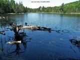
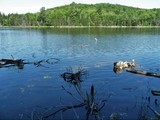
Lac-à-la-Croix is a beautiful small lake tributary of Lake Saint-François-Xavier, apparently still free from any human footprint; but only the elders could tell you more. Even if it has stopped being filtered by an active beaver dam, the water it discharges into our Lake must be impeccable. After the storm, the flow of incoming water is also not negligible.
At its head, Lac-à-la-Croix is directly accessible from Lake Saint-Victor by the Chemin-des-Berges-du-Nord, or from Lake-à-la-Croix road which breaks at a right angle in the latter. And yet, you cross the border between the Rivière-du-Nord and Rivière Rouge watersheds in the few steps that lead you from one lake to the other. Land seems currently cleared.
If Lac-à-la-Croix Sector road project materialises on our Lake, it is this new landscape that its residents will get familiarized with. But, as long as the trees keep their leaves, the Lake will not be directly visible from the current way.
Cottagers’ life at the head of Lake Saint-François-Xavier is perhaps at one turning point in its history. Furthermore, this discovery is just one of the all new and grandiose breakthroughs on our backyard the Orphans’ trail opens to hikers, skiers and especially... mountain bikers!
C. C.
Nord-Wentwortois, access road, etc.
Nord-Wentwortois, road access, exchange of lots, trails
MUNICIPALITÉ DE WENTWORTH-NORD
SÉANCE ORDINAIRE DU 12 AOÛT 2013 Saint-Michel de Wentworth
2013-08-179 PROPOSITION ET DÉNOMINATION D'UN GENTILÉ POUR LES RÉSIDANTS DE WENTWORTH-NORD
Il est proposé par la conseillère Diane Théorêt ET RÉSOLU À L'UNANIMITÉ des conseillers de soumettre le nom de Nord-Wentwortois à la Commission de Toponymie Québec pour approbation.
AVIS DE MOTION DE PLUSIEURS RÈGLEMENTS DÉCRÉTANT LES MODALITÉS DE PRISE EN CHARGE DE L'ENTRETIEN PARTIEL DE CERTAINS CHEMINS PRIVÉS POUR 2013-2014
"Le règlement décrétant les modalités de prise en charge de l'entretien partiel de la rue du Chemin-de-Fer (# 814 au # 1042 inclusivement) par la Municipalité" soit présenté pour adoption lors d'une session subséquente de ce conseil ;
AVIS DE MOTION – RÈGLEMENT D'EMPRUNT # 2013-401 POUR L'AMÉNAGEMENT DE ROUTES DANS LE SECTEUR THURSONDOCMANOV DANS MONTFORT
ATTENDU QUE suite au dépôt du rapport PAPA, concernant le lac Saint-François-Xavier, il a été identifié que plusieurs systèmes septiques ne respectent pas les normes en matière d'évacuation et de traitement des eaux usées applicables pour les résidences isolées;
ATTENDU QUE L'article 3 du Règlement sur le traitement et l'évacuation des eaux usées des résidences isolées Q-2, r.22 stipule que « Nul ne peut rejeter ni permettre le rejet dans l'environnement des eaux provenant du cabinet d'aisances d'une résidence isolée ou des eaux usées ou ménagères d'une résidence isolée. »
ATTENDU QUE tel qu'indiqué à l'article 86 de la Loi sur la qualité de l'environnement « Sans restreindre les pouvoirs du ministre à cet égard, il est du devoir des municipalités d'exécuter et de faire exécuter tout règlement du gouvernement adopté en vertu de la présente loi qui édicte que tel règlement ou certains articles de ce règlement sont appliqués par toutes les municipalités »
ATTENDU QUE l'article 25.1 de la Loi sur les compétences municipales stipule que « Toute municipalité locale peut, aux frais du propriétaire de l'immeuble, installer, entretenir tout système de traitement des eaux usées d'une résidence isolée au sens du Règlement sur l'évacuation et le traitement des eaux usées des résidences isolées (R.R.Q., 1981, chapitre Q-2, r.22) ou le rendre conforme à ce règlement. Elle peut aussi procéder à la vidange des fosses septiques de tout autre immeuble. »
ATTENDU QU'à la lumière des études menées, des estimés et solutions présentées ainsi que de toutes les autres considérations et contraintes dont il faut tenir compte dans une perspective de développement durable de son territoire, la Municipalité considère que la solution la meilleures réside dans la construction d'une route;
Il est proposé par le conseiller André Soucy ET RÉSOLU À L'UNANIMITÉ des conseillers de donner un avis de motion pour la présentation lors d'une séance subséquente de ce conseil, d'un projet de règlement # 2013-401 – Règlement décrétant un emprunt pour l'exécution de travaux de construction de routes dans le secteur Sud-Est du lac Saint-François-Xavier, soit pour les secteurs « Thurson » et « Docmanov » à Montfort, dont le remboursement sera fait par l'imposition d'une taxe annuelle prélevée (montant à déterminer) sur les immeubles imposables des secteurs concernés.
2013-08-195 DEMANDE D'APPUI POUR UNE PROPOSITION D'ÉCHANGE DE TERRAINS DÉPOSÉE PAR LE DOMAINE DU LAC SAINT-VICTOR AUPRÈS DU MINISTÈRE DES RESSOURCES NATURELLES
CONSIDÉRANT QUE Monsieur Gino Ramacieri du Domaine du Lac St-Victor inc est propriétaire de vastes terrains constitués d'une partie du lot 15B et d'une partie des lots 14A, 14B, 13A et 13B du rang 8;
CONSIDÉRANT QUE le ministère des Ressources naturelles du Québec est propriétaire du lot 15A bordant la partie ouest du lac Saint-Pierre;
CONSIDÉRANT QUE Monsieur Gino Ramacieri du Domaine du Lac St-Victor inc a déposé une proposition d'échange de terrain le 18 juin 2012 auprès du ministère des Ressources naturelles du Québec, dont copie est jointe à l'annexe 1 du présent formulaire de recommandation;
CONSIDÉRANT QUE le ministère des Ressources naturelles du Québec a répondu à cette requête le 7 juin 2013 mentionnant que le Ministère ne pouvait donner suite à sa proposition d'échange de terrains;
CONSIDÉRANT QUE Monsieur Ramacieri réitère sa demande auprès du ministère des Ressources naturelles du Québec le 22 juillet 2013 et souhaite à cet effet obtenir un appui de la Municipalité;
CONSIDÉRANT QUE Monsieur Ramacieri estime que la proposition d'échange, une fois réalisée, profiterait à la municipalité de Wentworth-Nord à raison d'un investissement estimé à trois millions de dollars (3 000 000 $);
Pour ces motifs, il est recommandé au conseil municipal d'appuyer Monsieur Ramacieri dans sa demande auprès du ministère des Ressources naturelles du Québec dans le cadre de sa proposition d'échange de terrain.
Il est proposé par le conseiller André Payette ET RÉSOLU À L'UNANIMITÉ des conseillers d'appuyer la demande de Monsieur Gino Ramacieri auprès du ministère des Ressources naturelles du Québec.
2013-08-196 DEMANDE D'APPUI DE LA MRC DANS LE CADRE DE TRAVAUX D'AMÉNAGEMENT DANS LE RÉSEAU LA MONTFORTAINE SITUÉ EN TERRES SOUS C.A.A.F. [(Convention d'approvisionnement et d'aménagement forestier (forêt publique)]
CONSIDÉRANT QUE l'importance du développement récréotouristique sur le territoire de la Municipalité de Wentworth-Nord;
CONSIDÉRANT les récents projets d'aménagement de sentiers non motorisés réalisés par la municipalité dans le secteur Montfort;
CONSIDÉRANT la volonté de la M.R.C. des Pays-d'en-Haut de contribuer à l'offre récréotouristique dans l'ouest du territoire;
CONSIDÉRANT QUE la M.R.C. des Pays-d'en-Haut doit procéder à des travaux d'aménagement dans le réseau La Montfortaine, lequel est situé en terres sous C.A.A.F. et cela dès cet automne;
CONSIDÉRANT QUE les travaux d'aménagement visent à rendre le réseau praticable quatre saisons, car à l'heure actuelle, il est aménagé pour les raquetteurs seulement; CONSIDÉRANT QUE les travaux impliquent de construire des passerelles pour traverser des cours d'eau ou de détourner de courts segments de sentiers afin de contourner les milieux humides;
CONSIDÉRANT QUE ces interventions nécessitent des permis et autorisations de la part du ministère des Ressources naturelles du Québec et que la M.R.C. doit fournir une résolution d'appui de la municipalité de Wentworth-Nord à l'égard du projet;
CONSIDÉRANT QUE le projet présenté par la M.R.C. des Pays-d'en-Haut est conforme à la réglementation municipale en vigueur;
Pour ces motifs, le Service de l'urbanisme recommande au conseil municipal d'appuyer le projet d'amélioration du réseau de sentiers La Montfortaine situé en terres publiques sous C.A.A.F. à Wentworth-Nord.
Il est proposé par le conseiller André Payette ET RÉSOLU À L'UNANIMITÉ des conseillers d'appuyer le projet d'amélioration du réseau La Montfortaine de Wentworth-Nord.
2013-08-197 AUTORISATION D'UNE DÉPENSE – PROJET D'AMÉNAGEMENT DES SENTIERS À MONTFORT
ATTENDU QU'il a été nécessaire, pour respecter les conditions exigées par l'un des propriétaires de terrains sur lequel nous avons obtenu un droit de passage, de modifier le parcours initialement prévu et assurer la réalisation du sentier multifonctionnel;
ATTENDU QUE la modification apportée au parcours proposé à entre autres conséquence de complexifier et de prolonger la réalisation des travaux de construction et le nombre d'heures de location de certains équipements nécessaires;
ATTENDU QUE l'entrepreneur estime qu'un montant additionnel de neuf mille cent dix-sept dollars et cinquante-deux sous (9 117,52$) sera nécessaire pour compléter le travail; Il est proposé par le conseiller Philippe Alary ET RÉSOLU À L'UNANIMITÉ des conseillers d'autoriser le paiement de cette facture.
http://wentworth-nord.ca/images/stories/pdf-conseil/2013/PV-2013-08-12.pdf